Hassocks
- For the floor cushion, see Hassock.
| Hassocks | |
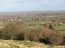
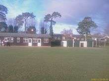
_1.jpg) Looking eastwards towards the centre of the village |
|
 Hassocks |
|
| Area | 10.88 km2 (4.20 sq mi) [1] |
|---|---|
| Population | 7,667 [1] 2011 Census |
| – density | 627/km2 (1,620/sq mi) |
| OS grid reference | TQ299154 |
| – London | 40 miles (64 km) N |
| Civil parish | Hassocks |
| District | Mid Sussex |
| Shire county | West Sussex |
| Region | South East |
| Country | England |
| Sovereign state | United Kingdom |
| Post town | HASSOCKS |
| Postcode district | BN6 |
| Dialling code | 01273 |
| Police | Sussex |
| Fire | West Sussex |
| Ambulance | South East Coast |
| EU Parliament | South East England |
| UK Parliament | Arundel and South Downs |
| Website | http://www.hassockspc.net/ |
|
|
Coordinates: 50°55′24″N 0°09′03″W / 50.923303°N 0.150863°W
Hassocks is a large village and civil parish in the Mid Sussex district of West Sussex, England. Its name is believed to derive from the tufts of grass found in the surrounding fields.[2][3]
Located approximately 7 miles (11 km) north of Brighton, with a population of 7,667,[4] the area now occupied by Hassocks was just a collection of small houses and a coaching house until the 19th century, when work started on the London to Brighton railway. Hassocks until 2000 was just a postal district and prior to that the name of the railway station. The Parishes were Clayton and Keymer, it is believed that when the railway came in 1841 the Parish Councils were given the opportunity of naming the station. But they could not agree and eventually the directors of the London, Brighton & South Coast Railway gave up waiting and named the station Hassocks Gate themselves.
History

Precolonial and colonial times
The area first became a centre of population around 20,000 years ago during the Stone Age. These people were mostly nomadic until approximately 5,000 years ago. Around this time, the first farmers settled on and around the South Downs, a mile to the south of the village. They travelled from the continent, bringing with them various types of farming livestock. Evidence of their existence has been found in the form of tools and dwellings around Stonepound Crossroads and in the Parklands area.
Around 600 B.C. the first metal workers came to the area with the beginning of the Bronze Age, and a good example of an Iron Age fort is to be found on the top of the nearby Wolstonbury Hill on the South Downs.[5]
The area was colonised by the Romans and a Roman cemetery was found by Stonepound Crossroads. Modern Hassocks is thought to have stood at a Roman crossroads on the London to Brighton Way between Londinium Augusta (modern London) to Novus Portus (possibly modern Portslade) (running north-south) and the Greensand Way Roman road from modern Hardham to a north-south road at Barford Mills north of Lewes and possibly further to Pevensey.[6][7] With the demise of the Roman Empire came an influx of Anglo-Saxons and the eventual reintroduction of stone buildings, such as the parish church of St. John the Baptist in the nearby village of Clayton, which is believed to have been built around the 11th Century.
19th and 20th centuries
The opening on 21 September 1841 of Hassocks Gate station (named after the nearby toll gate on the turnpike road to Brighton, but now known simply as Hassocks) on the London to Brighton railway saw the beginning of the village that we know today. South of the village the railway passes beneath the chalk escarpment of the South Downs through Clayton Tunnel, which at 6,777 feet (2,066 m) is the longest of the five tunnels on the railway. The north entrance of the tunnel is distinguished by a castellated portal with a dwelling house between the two towers. The latter might have been built for the use of the man who had to look after the gas lighting in the tunnel (for several years after opening the interior of the tunnel was whitewashed and lit by gas lamps, presumably to allay the fears of early railway travellers).[8] In 1861 a collision between two trains within the tunnel killed 23 people and injured 176 others.
In the 1930s the Grand Avenue residential area, along with several other roads, was developed by George Ferguson on the site of former orchards and the Orchard Pleasure Gardens. A special feature of the Hassocks Homes development ordered by Mr Ferguson was the planting of flowering cherry trees along the main roads.
1939 saw the beginning of World War II, and the closure of the cinema in September of that year (it was still going in the 1950s). Evacuations then began from London bringing an additional 1,250 to the population.
Recent history
.jpg)
Today Hassocks has a variety of independent shops including several cafes, specialist shops like the long established delicatessen, an optician, general hardware store & a couple of restaurants (Indian and Chinese) and a well-used community centre called Adastra Hall. In 2010 well known high street brands started to show an interest in the high street & modernisation of quaint old shops has seen the quirky give way to the corporate.
The former council buildings housing the road maintenance department on London Road have been demolished and have become a number of homes, whilst the land given to the people of Hassocks (via East Sussex County Council) by a benefactor, currently used by a children's charity, is being built upon, the charity having claimed ownership.[9]
Two miles west of Hassocks in the adjoining village of Hurstpierpoint lies Danny House, an Elizabethan manor where David Lloyd George came to draw up terms for the armistice at the end of World War I.
On the downs above Hassocks there are two windmills, named Clayton Windmills but known locally as "Jack and Jill". Jack is a tower mill and was built in 1866. Jill, a post mill, was built in Dyke Road in Brighton in 1821 and was later moved to Clayton in 1852 by a team of oxen. The working life of the mills ended in about 1906, and Jack is now in private ownership; Jill was restored in 1986 and is open to the public. To the North East of the village can be found Oldland Mill.
Landmarks

There is a Site of Special Scientific Interest within the parish. Clayton to Offham Escarpment, which stretches from Hassocks in the west, passing through many parishes including Ditchling, to Lewes in the East. This site is of biological importance due to its rare chalk grassland habitat along with its woodland and scrub.[10]
To the south of Hassocks is a small 7.12 hectares (17.6 acres) ancient woodland known as Butchers Wood. The wood is mainly oak and hazel with a large bluebell ground flora.[11] It was acquired by the Woodland Trust in 1988.
On the north-western edge of the village, on the London Road, is the Friars Oak, formerly a coaching inn, adjoining open meadows known as Friars Oak Fields.
Railway station
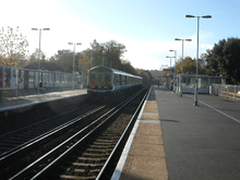
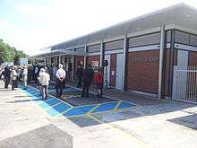
Hassocks railway station serves the village. Thameslink and Southern provide regular train services to Brighton, London and Bedford. The station was rebuilt and redeveloped in 2013, the new main station building was opened on 5 July with the addition of lifts on both platforms completed by December 2013.[12]
Education

Hassocks Infant School is a maintained infant school for pupils aged 4 to 7 and built in 1877 as a Victorian Board School. It currently caters for around 210 pupils. The school is centrally located in the village. It has been considerably enlarged in the recent past with three new classrooms, a large hall and a library area being added to the original Victorian building. The Headteacher is Jeannie Hughes who has a teaching staff of 9 and the Chair of Governors is David Withycombe.[13] Plans for a major new extension to bring the school up to a three form entry infant school were presented to the public on 4 July 2013.[14] [15][16]
Secondary education for the village and surrounding areas is provided by Downlands Community School. Downlands does not have a sixth form and children wishing to do 'A' levels have to travel to a variety of sixth form colleges, including Varndean College, St Paul's Catholic College (Burgess Hill), Brighton Hove & Sussex Sixth Form College and Hurstpierpoint College. Downlands Community School has a sports hall and AstroTurf football pitch funded by the late Chelsea F.C. vice-chairman Matthew Harding's wife.
Sport

In late 2010 the 30-year-old sports pavilion was demolished to make way for a new 'green' building designed by Ecotecture[17] and completed in April 2011. The new building is state of the art and built to very stringent airtight tolerances utilising the latest air source heat pump technologies.[18]
There are several specific football pitches in Adastra Park where both junior and senior games are played and the park is also the home to Keymer & Hassocks Cricket Club the primary users of the sports pavilion. Adastra Park also has a skate park and two playgrounds suitable for children of all ages. A 5 a-side football competition often takes place in August in the park, in which teams from the whole of the south east compete in a day long tournament.
Hassocks F.C. play at the nearby Beacon Ground with the first team playing in SCFL Div One.[19] In addition there are three municipal tennis courts in Adastra Park and the 'Weald Tennis and Squash Club' on South Bank is a significant club in the village.
Hassocks Golf Club is an 18-hole, par 70 golf course (5754 yards, 5260 metres) on the western edge of the village that was opened in 1995 and is the only golf course in the area that is a 'pay and play' club.
Neighbourhood plan
The Parish Council [20] are currently producing the Hassocks Neighbourhood Plan and are currently consulting with stakeholders prior to continuing the process to full publication.[21]
Twin towns
Hassocks's twin towns are:
Notable people
- Martin Dugard, motorcycle racer
- Patrick Hamilton, the playwright and novelist, was born here in 1904.
- Jonathan Pearce the football commentator, known for his work on Match of the Day and Robot Wars, lives in Hassocks.[22]
- Raymond Briggs, English cartoonist, creator of The Snowman, Father Christmas and Fungus the Bogeyman, lives in Hassocks.[23]
- Austen Albu, former British Labour Member of Parliament for Edmonton (UK Parliament constituency), former Minister of State for Economic Affairs, lived in Hassocks with his wife, social psychologist Marie Jahoda.[24]
References
- 1 2 "2001 Census: West Sussex – Population by Parish" (PDF). West Sussex County Council. Archived from the original (PDF) on 8 June 2011. Retrieved 7 April 2009.
- ↑ "Hassocks Parish Council".
- ↑ "Online Anglo-Saxon Dictionary (see entry for "hassuc")".
- ↑ "Hassocks Demographics (Mid Sussex, England)".
- ↑ "Mid Sussex District Official Guide". Localauthoritypublishing.co.uk. Retrieved 2014-02-25.
- ↑ Togodumnus (Kevan White). "Hassocks". Roman-britain.org. Retrieved 2014-02-25.
- ↑ The course of the London to Brighton Roman road south of Burgess Hill by Glen Shields p86 Retrieved 26 October 2008
- ↑ Turner, John Howard (1977). The London Brighton and South Coast Railway 1 Origins and Formation. Batsford. pp. 122, 123, 141–2. ISBN 0-7134-0275-X.
- ↑ "Stafford House trustees release statement".
- ↑ "Natural England - SSSI (Clayton to Offham Escarpment)". English Nature. Retrieved 5 October 2008.
- ↑ "Butcher's Wood - Hassocks". Our woods in focus. Woodland Trust. Retrieved 29 April 2009.
- ↑ "Plans revealed for new station at Hassocks : Southern". Southernrailway.com. 2011-12-06. Retrieved 2014-02-25.
- ↑ about Archived 10 April 2011 at the Wayback Machine.
- ↑ http://www2.westsussex.gov.uk/ds/mis/250712es10.pdf
- ↑ "2003 Ofsted report". Ofsted.gov.uk. Retrieved 2014-02-25.
- ↑ 2007 Ofsted report
- ↑ "Welcome to Ecotecture". Ecotecture.co.uk. 2011-03-25. Retrieved 2014-02-25.
- ↑ News - Hassocks Parish Council Archived 14 August 2010 at the Wayback Machine.
- ↑ "Hassocks Football Club - Official Website of the Robins". Hassocksfc.net. Retrieved 2014-02-25.
- ↑ "Hassocks Parish Council". Hassocks Parish Council.
- ↑ http://hassockspc.net/wp-content/uploads/2014/07/Regulation-14-Consultation-Plan-Final-compressed1.pdf
- ↑ http://www.hassocksfc.net/info.htm
- ↑ Europa Publications (2003). International Who's Who of Authors and Writers 2004. Psychology Press. pp. 3–. ISBN 978-1-85743-179-7.
- ↑ "About Us - Hassocks Amenity Association". Hassocksamenity.org.uk. Retrieved 2016-02-15.
Historical Map and Guide - Roman Britain by the Ordnance Survey (3rd, 4th & 5th eds., 1956, 1994 & 2001); Oxford Dictionary of English Place-Names by A.D. Mills (Oxford 1998).
External links
| Wikimedia Commons has media related to Hassocks. |