List of hills of Cornwall
This is a list of hills in Cornwall based on data compiled in various sources, but particularly the Database of British and Irish Hills, Jackson's More Relative Hills of Britain[1] and the Ordnance Survey 1:25,000 Explorer and 1:50,000 Landranger map series.
Many of these hills are important historic, archaeological and nature conservation sites, as well as popular hiking and tourist destinations in the county of Cornwall in southwest England.
Colour key
| Class | Prominence |
|---|---|
| Marilyns | 150 - 599 m |
| HuMPs | 100 - 149 m |
The table is colour-coded based on the classification or "listing" of the hill. The two types that occur in Cornwall are Marilyns and HuMPs, listings based on topographical prominence. "Prominence" correlates strongly with the subjective significance of a summit. Peaks with low prominences are either subsidiary tops of a higher summit or relatively insignificant independent summits. Peaks with high prominences tend to be the highest points around and likely to have extraordinary views. A Marilyn is a hill with a prominence of at least 150 metres or about 500 feet.[2] A "HuMP" (the acronym comes from "Hundred Metre Prominence) is a hill with a prominence of at least 100 but less than 150 metres.[3] In this table Marilyns are in beige and HuMPs in lilac. The term "sub-Marilyn" or "sub-HuMP" is used, e.g. in the online Database of British and Irish Hills to indicate hills that fall just below the threshold. To qualify for inclusion, hills must either be 200 metres or higher with a prominence of at least 30 metres, below 200 metres with a prominence of at least 90 metres (the threshold for a sub-HuMP) or be in some other way notable. For further information see the Lists of mountains and hills in the British Isles and the individual articles on Marilyns and HuMPs.
| Hill | Height (m) | Prom. (m) | Grid ref. | Class | Parent | Range/Region | Remarks | Image |
|---|---|---|---|---|---|---|---|---|
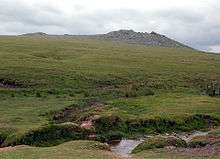
| Brown Willy[1] | 420 | 314 | SX158799 | Marilyn | High Willhays | Bodmin Moor | Cornwall's county top. Highest of Cornwall's 5 Marilyns. |
 |
| Rough Tor[4] | 400 | 87 | ST413011 | TuMP | Brown Willy | Bodmin Moor | Bodmin Moor's second highest summit. Site of tor cairn and historic settlements and monuments. |
 |
| Kilmar Tor[1] | 396 | 118 | SX252748 | HuMP | Brown Willy | Bodmin Moor | Tor 50m SW of summit trig point |  |
| Stowe's Hill[4] | 381 | 78 | SX257724 | TuMP | Bodmin Moor | Massive tor enclosure (Stowe's Pound) and site of the Cheesewring |
 | |
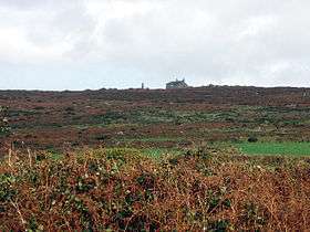
| Caradon Hill[4] | 371 | 69 | SX272707 | TuMP | Bodmin Moor | Caradon Hill transmitting station, former mining area |  | |
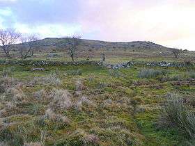
| Brown Gelly[4] | 342 | 74 | SX196727 | TuMP | Brown Willy | Bodmin Moor | Tor, hut circles, barrows and cairns. |  |
| Kit Hill[1] | 334 | 171 | SX374713 | Marilyn | Brown Willy | Cornish Killas | One of Cornwall's five Marilyns Highest point in Cornwall outside Bodmin Moor |
 |
| Garrow Tor[4] | 330 | 57 | SX374713 | TuMP | Bodmin Moor | Several tors and extensive Bronze Age and Medieval settlements, hut circles, etc. |
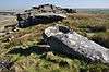 | |
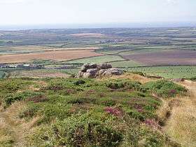
| Hawk's Tor[4] | 329 | 36 | SX253763 | TuMP | Bodmin Moor | Site of Stripple stones, stone circle, Hawkstor Pit SSSI |  | |
| Hensbarrow Beacon[1] | 312 | 193 | SW996575 | Marilyn | Brown Willy | Hensbarrow | One of Cornwall's five Marilyns Summit dominated by spoil heaps of china clay mine |
|
| Condolden Barrow[4] |
308 | 50 | SX090872 | TuMP | Cornish Killas | Summit trig point, Bronze Age barrows Second highest point in Cornwall outside Bodmin Moor |
||
| Alex Tor[4] | 291 | 30 | SX118787 | TuMP | Bodmin Moor | Summit tor cairn |  | |
| Carnmenellis[1] | 252 | 165 | SW695364 | Marilyn | Hensbarrow Beacon | Carnmenellis | One of Cornwall's five Marilyns Summit trig point |
 |
| Watch Croft[1] | 252 | 225 | SW420357 | Marilyn | Brown Willy | West Penwith | One of Cornwall's five Marilyns Trig point nr summit |
 |
| Carn Marth[4] | 235 | 60 | SW715408 | TuMP | Carnmenellis | Site of former granite quarry |  | |
| Carn Brea[4] | 228 | 47 | SW683407 | TuMP | Carnmenellis | Neolithic and Iron Age settlement |  | |
| Castle Downs[5] | 216 | 67 | SW945623 | TuMP | Cornish Killas | Site of major Iron Age fort: Castle an Dinas |  | |
| Helman Tor[4] | 210 | 37 | SX062615 | TuMP | Hensbarrow | Tor, nature reserve, logan stone, prehistoric hillfort and stone hut circle |
 | |
| Bin Down[1] | 203 | 101 | SX276578 | HuMP | Kilmar Tor | Cornish Killas | Tall man-made mound on summit On Looe Golf Course by 7th tee. |
|
| Chapel Carn Brea[5][6] | 198 | 30 | SW386280 | HuMP | West Penwith | Hercynian granite outcrop; Westernmost hill in Britain Site of old chapel, beacon |
 | |
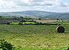
| Tregonning Hill[1] | 194 | 102 | SW599300 | HuMP | Carnmenellis | Cornish Killas | Summit trig point | 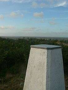 |
| Brea Hill[4] | 62 | 41 | SW928771 | TuMP | Cornish Killas | Bronze Age tumuli at summit |  |
See also
References and footnotes
- 1 2 3 4 5 6 7 8 9 Name, height, prominence, grid, class and parent data from: Jackson, Mark (2009). More Relative Hills of Britain, Marilyn News Centre, UK, p. 168. E-book.
- ↑ Dawson, Alan (1992). The Relative Hills of Britain. Milnthorpe: Cicerone Press. ISBN 1-85284-068-4.
- ↑ Jackson, Mark. "More Relative Hills of Britain" (PDF). Relative Hills of Britain. Retrieved 31 March 2013.
- 1 2 3 4 5 6 7 8 9 10 11 12 Name, height, prominence, grid and class data from Database of British and Irish Hills - Dorset. Accessed on 01 Sep 2013.
- 1 2 Tumps, P30 Appendix v2.1 to the Database of British and Irish Hills at www.hills-database.co.uk. Accessed on 4 Sep 2013
- ↑ Bond, Chris (2007). An Index to the Historical Place Names of Cornwall: Vol 1 - A to K. East Sussex: The Cornovia Press. ISBN 978-0952206446. Retrieved 4 January 2015.
Lists of hills of Southern England | ||
|---|---|---|
 | ||