Geography of Cornwall
| Geography of Cornwall | |
 | |
| Continent | Europe |
| Island | Great Britain |
| Coordinates | 50°18′N 4°54′W / 50.3°N 4.9°W |
| Area | Ranked 9th out of 82 counties 3,563 km² (1,376 mi²) |
| Coastline | 697 km (422 mi) |
| Highest point | Brown Willy 420 m (1,378 ft) |
| Lowest point | Sea level |
| Longest river | River Tamar (border) 94 km (58 mi) River Camel (within Cornwall) 50 km (31 mi) |
| Largest lake | The Loe |
| Look up Cornwall in Wiktionary, the free dictionary. |
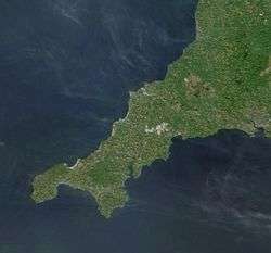
The geography of Cornwall describes the extreme southwestern peninsula of England west of the River Tamar. The population of Cornwall is greater in the less extensive west of the county than the east due to Bodmin Moor's location; however the larger part of the population live in rural areas. It is the only county in England bordered by only one other county, Devon, and is the 9th largest county by area, encompassing 3,563 km² (1,376 mi²). The length of the coast is large in proportion to the area of the county. Cornwall is exposed to the full force of the prevailing south-westerly winds that blow in from the Atlantic Ocean. To the north is the Celtic Sea, and to the south the English Channel.
Cornwall is the location of Great Britain's most southerly point, The Lizard, and the southern mainland's most westerly point, Land's End. A few miles further west are the Isles of Scilly.
Physical geography
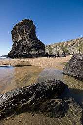
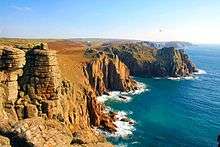
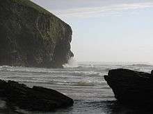
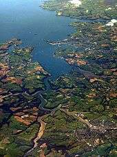
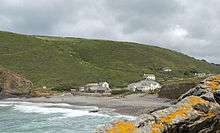
Cornwall is located at 50°30′N 5°00′W / 50.5°N 5°W. The highest point is Brown Willy at 420 m (1,378 ft), part of the granite Bodmin Moor, of which such intrusions are covered by rough grass, heather and bog flora. Woodland is prevented from growing on the granite uplands because of the poor soil and the height giving them the full force of the wind and climate. The rest of the inland contains pastureland and arable farmland. The coastline, at 697 km (422 mi),[1] is mostly occupied by high cliffs, but also featuring islets, stacks, coves and bays. Lowland stretches are also to be found, particularly along the south coast, sometimes backed by large expanses of towans or dunes such as near Par. The Isles of Scilly are the largest archipelago in the British Isles outside Scotland. The largest other islands are off the south coast: Looe Island and St Michael's Mount.
Cornwall has varied habitats including terrestrial and marine ecosystems. One of the lower plant forms in decline locally is the Reindeer lichen, which has been made a priority for protection under the national UK Biodiversity Action Plan.
National character areas
The national character areas recognised by Natural England that lie wholly or partially on Cornish soil are:
|
|
|
Geology
Cornwall was one of the most important mining areas in Europe until the 20th century, due to its intrusions of granite into surrounding sedimentary rocks which resulted in metamorphism and mineralisation. Bodmin Moor and Carn Brea are examples of such granite intrusion. The Lizard peninsula is an example of an ophiolite.
The north coast is more exposed to the prevailing winds from the Atlantic Ocean than the south coast and is more rugged, with many sheer cliffs and steep valleys. The south coast is more sheltered and is interrupted by several rias which provide deep water harbours such as Carrick Roads.
Human geography
From 1889 to March 2009 Cornwall was administered by Cornwall County Council; the second level of local government included municipal boroughs, urban districts and rural districts, and within each of these were a number of civil parishes. Cornwall consisted from April 1974 to March 2009 of six districts, which are, from west to east: Penwith, Kerrier, Carrick, Restormel, North Cornwall, and Caradon. While traditionally administered as part of Cornwall, the Isles of Scilly are now a separate unitary authority though they are included in the ceremonial county. Natural resources include: granite, slate, tin, copper and kaolinite. Agricultural land: 73.64%; Woodland cover: 7.5%; Other types: 18.86%. The deposits of tin, copper and kaolinite were heavily exploited during the 19th and 20th centuries. Some species of fish are abundant in the coastal waters; the pilchard fishery was of great importance from the late 18th to the early 20th century.
Climate
Cornwall has a temperate Oceanic climate (Köppen climate classification: Cfb) and has the mildest and sunniest climate in the United Kingdom, as a result of its southerly latitude and the influence of the Gulf Stream.[2] The average annual temperature in Cornwall ranges from 11.6 °C (53 °F) on the Isles of Scilly to 9.8 °C (52 °F) in the central uplands. Winters are amongst the warmest in the country due to the southerly latitude and moderating effects of the warm ocean currents, and frost and snow are very rare at the coast and are also rare in the central upland areas. Summers are however not as warm as those of other areas in southern England. The surrounding sea and its southwesterly position mean that Cornwall's weather is relatively changeable.
Cornwall is one of the sunniest areas in the UK, with over 1541 hours of sunshine per year, with the highest average of 7.6 hours of sunshine per day in July.[3] The moist, mild air coming from the south west brings higher amounts of rainfall than in eastern Great Britain, at 1051 to 1290 mm (41.4 to 50.8 in) per year, however not as much as in more northern areas of the west coast.[4] The Gulf Stream, bringing warm air from the Caribbean north-east toward Europe, makes Cornwall's weather distinctly milder than other places in the world at the same latitude, such as Newfoundland. Also due to the Gulf Stream, Cornwall has the UK's only area of sub-tropical climate, at the extreme south-west of Cornwall and the Isles of Scilly. Palm trees are a common sight in these areas. The sub-tropical nature has resulted in a number of botanical gardens, such as Trebah and the Lost Gardens of Heligan.
The Isles of Scilly, for example is the warmest place in the whole of Great Britain with an average temperature of 11.6 °C, where there are on average less than 2 days of air frost per year, are in the USDA Hardiness zone 10, is the only area in the UK that is in this zone. In Scilly there is on average less than 1 day of air temperature exceeding 30 °C per year and it is in the AHS Heat Zone 1. Pendennis Point in Falmouth is the warmest place on mainland Great Britain, with an average temperature of 11.4 °C (52.5 °F).[5]
Extreme temperatures in Cornwall are particularly rare, however extreme weather in the form of storms and floods is common. The Shipping Forecast areas bordering on Cornwall are Lundy (north coast) and Plymouth (south coast).
Temperature tables
| Climate data for Bude | |||||||||||||
|---|---|---|---|---|---|---|---|---|---|---|---|---|---|
| Month | Jan | Feb | Mar | Apr | May | Jun | Jul | Aug | Sep | Oct | Nov | Dec | Year |
| Average high °C (°F) | 9 (48) |
9 (48) |
10 (50) |
12 (54) |
15 (59) |
17 (63) |
19 (66) |
19 (66) |
18 (64) |
15 (59) |
12 (54) |
10 (50) |
14 (57) |
| Average low °C (°F) | 4 (39) |
3 (37) |
4 (39) |
5 (41) |
8 (46) |
10 (50) |
13 (55) |
13 (55) |
11 (52) |
9 (48) |
6 (43) |
5 (41) |
8 (46) |
| Source: Weather Channel[6] | |||||||||||||
| Climate data for Helston | |||||||||||||
|---|---|---|---|---|---|---|---|---|---|---|---|---|---|
| Month | Jan | Feb | Mar | Apr | May | Jun | Jul | Aug | Sep | Oct | Nov | Dec | Year |
| Average high °C (°F) | 8 (46) |
8 (46) |
10 (50) |
12 (54) |
14 (57) |
17 (63) |
19 (66) |
19 (66) |
17 (63) |
14 (57) |
11 (52) |
9 (48) |
13 (55) |
| Average low °C (°F) | 4 (39) |
4 (39) |
5 (41) |
6 (43) |
8 (46) |
11 (52) |
13 (55) |
13 (55) |
11 (52) |
9 (48) |
6 (43) |
5 (41) |
8 (46) |
| Source: Weather Channel[7] | |||||||||||||
| Climate data for Isles of Scilly, Cornwall | |||||||||||||
|---|---|---|---|---|---|---|---|---|---|---|---|---|---|
| Month | Jan | Feb | Mar | Apr | May | Jun | Jul | Aug | Sep | Oct | Nov | Dec | Year |
| Average high °C (°F) | 9 (48) |
9 (48) |
11 (52) |
12 (54) |
14 (57) |
17 (63) |
19 (66) |
19 (66) |
18 (64) |
15 (59) |
12 (54) |
10 (50) |
13.8 (56.8) |
| Average low °C (°F) | 6 (43) |
6 (43) |
7 (45) |
7 (45) |
9 (48) |
12 (54) |
13 (55) |
14 (57) |
13 (55) |
11 (52) |
9 (48) |
7 (45) |
9.3 (48.7) |
| Average precipitation mm (inches) | 91 (3.58) |
71 (2.8) |
69 (2.72) |
46 (1.81) |
56 (2.2) |
49 (1.93) |
61 (2.4) |
64 (2.52) |
67 (2.64) |
80 (3.15) |
96 (3.78) |
94 (3.7) |
844 (33.23) |
| Average precipitation days | 22 | 17 | 16 | 13 | 14 | 14 | 16 | 15 | 16 | 17 | 19 | 21 | 200 |
| Mean monthly sunshine hours | 61 | 83 | 135 | 186 | 229 | 229 | 238 | 225 | 164 | 121 | 77 | 57 | 1,805 |
| Source: Climate Data for Isles of Scilly[8] | |||||||||||||
| Climate data for Liskeard | |||||||||||||
|---|---|---|---|---|---|---|---|---|---|---|---|---|---|
| Month | Jan | Feb | Mar | Apr | May | Jun | Jul | Aug | Sep | Oct | Nov | Dec | Year |
| Average high °C (°F) | 8 (46) |
8 (46) |
9 (48) |
12 (54) |
14 (57) |
17 (63) |
19 (66) |
19 (66) |
17 (63) |
14 (57) |
11 (52) |
9 (48) |
13 (55) |
| Average low °C (°F) | 3 (37) |
3 (37) |
4 (39) |
5 (41) |
8 (46) |
11 (52) |
13 (55) |
13 (55) |
11 (52) |
9 (48) |
6 (43) |
4 (39) |
8 (46) |
| Source: Weather Channel[9] | |||||||||||||
| Climate data for Truro, Cornwall | |||||||||||||
|---|---|---|---|---|---|---|---|---|---|---|---|---|---|
| Month | Jan | Feb | Mar | Apr | May | Jun | Jul | Aug | Sep | Oct | Nov | Dec | Year |
| Average high °C (°F) | 8 (46) |
8 (46) |
10 (50) |
12 (54) |
15 (59) |
17 (63) |
19 (66) |
19 (66) |
17 (63) |
14 (57) |
11 (52) |
9 (48) |
13.3 (55.8) |
| Average low °C (°F) | 5 (41) |
4 (39) |
5 (41) |
6 (43) |
8 (46) |
11 (52) |
13 (55) |
14 (57) |
12 (54) |
10 (50) |
7 (45) |
6 (43) |
8.4 (47.2) |
| Average precipitation mm (inches) | 81 (3.19) |
63 (2.48) |
49 (1.93) |
54 (2.13) |
40 (1.57) |
47 (1.85) |
48 (1.89) |
51 (2.01) |
57 (2.24) |
87 (3.43) |
87 (3.43) |
78 (3.07) |
742 (29.22) |
| Source: Foreca[10] | |||||||||||||
Natural hazards
Cornwall is not known for being prone to natural hazards, although they do happen. The county experiences droughts and heat waves with the rest of Europe as they happen, but its location close to the ocean dampens their severity. Also, European windstorms in the winter usually make landfall on the west coast of Europe, including Cornwall, resulting in severe gales and flooding. Cornwall's large amount of valleys also make it prone to rapid flooding when an unusually heavy amount of rainfall occurs, as seen in the Boscastle flood of 2004.
Although not lying on any plate boundary, Britain occasionally experiences intraplate tremors as a result of the Eurasian Plate's motion, reactivating weak points in the rock. The west coast is more prone to these tremors than the east.[11] The strongest tremor so far recorded in Cornwall was in 1815, measuring 4.4 on the Richter scale with its epicentre near Penzance.[12]
The 1755 Earthquake in Lisbon, Portugal which measured 9.0 on the Richter scale sent a tsunami towards the south coast of Cornwall. Historical accounts describe the waves of 3 metres (10 feet) in height and significant loss of life and property.[13]
Names for Cornwall in languages other than English
Cornwall's unique history has distinguished it enough for other languages to form their own name for it. While other counties have transliterations of their names or Celtic-language names, Cornwall is unique in the number of European languages that have given it their own name; in the United Kingdom only countries such as England, Scotland and Wales usually have this.
| Language | Name | Notes | Reference |
| Arabic | كورنوال | ||
| Asturian | Cornualles | ||
| Basque | Kornualles | ||
| Breton | Kernev-Veur | ||
| Bulgarian | Корнуол | ||
| Catalan | Cornualla | ||
| Chinese | 康沃尔 (Simplified) 康沃爾 (Traditional) 歌和老/康和 (Hong Kong) | Mandarin (Pinyin): kāng wò ěr Cantonese (Yale): hong1 yuk1 yi5/ko1 wo4 lou5/hong1 wo4 | |
| Cornish | Kernow | [14] | |
| Dutch | Cornwallis | Archaic; no longer used. | |
| Esperanto | Kornvalo | ||
| French | Cornouailles | [15] | |
| Galician | Cornualles | ||
| Greek | Κορνουάλλη | Romanised: Kornoualli | |
| Hebrew | קורנוול | ||
| Hindi | कॉर्नवल | Transliteration: Kornaval | |
| Icelandic | Kornbretaland | Cornwall is also used. | |
| Ido | Kornwal | ||
| Irish | Corn na Breataine | ||
| Italian | Cornovaglia | [16] | |
| Japanese | コーンウォール | Romaji: kōn'uōru | |
| Korean | 콘월 주 | Romanised: konuuil ju | |
| Latin | Cornubia | ||
| Latvian | Kornvola | ||
| Leonese | Cornualles | ||
| Lithuanian | Kornvalis | ||
| Manx | Yn Chorn | ||
| Occitan | Cornoalha | ||
| Polish | Kornwalia | ||
| Portuguese | Cornualha | ||
| Russian | Корнуолл | Romanised: Kornuoll | |
| Scottish Gaelic | A' Chòrn | ||
| Sicilian | Curnuvagghia | ||
| Upper Sorbian | Korniska | ||
| Spanish | Cornualles | ||
| Turkish | Kernevekeli | ||
| Welsh | Cernyw | ||
See also
.jpg)
- Flora and fauna of Cornwall
- List of hills of Cornwall
- List of Special Areas of Conservation in Cornwall
References
- ↑ Cornwall County Council – Profile of the Cornish Landscape
- ↑ Met Office, 2000. Annual average temperature for the United Kingdom.
- ↑ Met Office, 2000. Annual average sunshine for the United Kingdom.
- ↑ Met Office, 2000. Annual average rainfall for the United Kingdom.
- ↑ Ash, Russell (2006). The Top 10 of Everything 2007. Hamlyn. ISBN 978-0- 600-61532-3.
- ↑ Bude travel information Weather Channel UK Retrieved 4 April 2009
- ↑ Helston travel information Weather Channel UK Retrieved 4 April 2009
- ↑ "Average Weather for Isles of Scilly, ENG — Temperature and Precipitation".
- ↑ Liskeard travel information Weather Channel UK Retrieved 4 April 2009
- ↑ "Weather Averages - Truro, England". Foreca. Retrieved 2008-05-20.
- ↑ Earthquake shakes south west England – BBC News
- ↑ Earthquakes in the South West – South West Observatory
- ↑ First of November, the Earthquake day – Oliver Wendell Holmes
- ↑ Cornwall County Council – Cornwall Centre (Kresenn Kernow) (English)
- ↑ La Cornouailles et le Devon: pourquoi visiter les comtés (French)
- ↑ Cornovaglia, Alloggi Cornovaglia, Vacanze Cornovaglia (Italian)
Further reading
- Gascoyne, Joel A Map of the County of Cornwall, 1699; reprinted in facsimile with an introduction by William L.D. Ravenhill and O.J. Padel (Devon and Cornwall Record Society: new series; vol. 34.); Exeter: Devon and Cornwall Record Society, 1991.
- Henderson, Charles & Coates, Henry (1928) Old Cornish Bridges and Streams. London: published for the University College of the South West by Simpkin Marshall
- Kain, Roger; Ravenhill, William (eds.) (1999) Historical Atlas of South-West England. Exeter: University of Exeter Press
External links
| Wikimedia Commons has media related to Geography of Cornwall. |
Cornwall Portal | |
| Unitary authorities | |
| Major settlements |
|
| Rivers | |
| Topics | |