List of heritage sites in Caledon
This is a list of the heritage sites in Caledon, situated in the Western Cape, as recognized by the South African Heritage Resources Agency.[1]
| SAHRA identifier | Site name | Description | Town | District | NHRA status | Coordinates | Image |
|---|---|---|---|---|---|---|---|
| 9/2/015/0001 | Caledon Hot Springs, Caledon | Caledon | Caledon | 34°13′32″S 19°26′14″E / 34.225450°S 19.437152°E | 
| ||
| 9/2/015/0002 | GENADENDAL, CALEDON DISTRICT, GENERAL | Genadendal | Caledon |
| |||
| 9/2/015/0003 | CALEDON MUNICIPAL AREA, GENERAL | Caledon | Caledon |
| |||
| 9/2/015/0004 | 7 Donkin Street, Caledon | Double storey house with a splay corner and stepped parapets.
Cornice with round and rctangular vents below 6 x 6 sashes and 2 x 2 door with geometric fanlight on the corner.
Very fine plasterwork, including quoins and keystones over openings, with unusu
|
Caledon | Caledon | Provincial Heritage Site | 34°13′59″S 19°25′39″E / 34.233042°S 19.427533°E |  |
| 9/2/015/0005 | 24 Mill Street, Caledon | House with hipped roof, with central covered gable and two projecting gables with bay windows under their own saddle roofs.
The house has been renovated at time of survey.
Gables all have fine fretted barge boards with finials and round vents with plast
|
Caledon | Caledon | Provincial Heritage Site | 34°13′53″S 19°25′52″E / 34.231460°S 19.431129°E |
|
| 9/2/015/0006 | Dagbreek Museum/Restaurant, 13 Graaff Street, Villiersdorp | Type of site: House
|
Villiersdorp | Caledon | Provincial Heritage Site | 33°59′21″S 19°17′23″E / 33.989076°S 19.289636°E |
|
| 9/2/015/0007 | De Villiers Graaff High School, Graaff Street, Villiersdorp, Caledon | Villiersdorp | Caledon | Pending Declaration | 33°59′08″S 19°17′30″E / 33.985459°S 19.291756°E |
| |
| 9/2/015/0008 | D R Vatem Hall, Van Riebeeck Street, Villiersdorp, Caledon | Villiersdorp | Caledon | Pending Register |
| ||
| 9/2/015/0009 | Combrincks Gift, D R Church Parsonage, Main Street, Villiersdorp, | Villiersdorp | Caledon | Pending Register |
| ||
| 9/2/015/0010 | Genadendal Mission Complex, Genadendal | Mission station founded in 1737 by George Schmidt and is the oldest in SA.
Buildings date from 18 and 19th centuries.
|
Genadendal | Caledon | Provincial Heritage Site | 34°02′01″S 19°33′27″E / 34.033743°S 19.557397°E |  |
| 9/2/015/0010-015 | Bell tower, Mission Complex, Genadendal | Genadendal, one of the most picturesque villages in the Overberg, lies in this mountain valley with its spectacular scenery.
The centre of the village is the mission station with its complex of buildings of the greatest historical and cult
|
Genadendal | Caledon | Provincial Heritage Site | 34°02′01″S 19°33′27″E / 34.033602°S 19.557398°E |  |
| 9/2/015/0010/001 | Contents of Mission Museum, Genadendal | Genadendal | Caledon | Heritage Object |  | ||
| 9/2/015/0010/002 | Hallbeck House, Mission Complex, Genadendal | Type of site: House | Genadendal | Caledon | Provincial Heritage Site | 34°02′01″S 19°33′28″E / 34.033617°S 19.557688°E |  |
| 9/2/015/0010/003 | Kuhnel House, Mission Complex, Genadendal | Type of site: House | Genadendal | Caledon | Provincial Heritage Site | 34°02′04″S 19°33′27″E / 34.034358°S 19.557377°E |  |
| 9/2/015/0010/1 | Contents of Mission Museum, Genadendal, Caledon District | Genadendal | Caledon | Cultural Treasure | 34°02′59″S 19°36′26″E / 34.049788°S 19.607207°E |
| |
| 9/2/015/0010/4 | Watermill, Mission Complex, Genadendal, Caledon District | Genadendal | Caledon | National Monument | 34°02′59″S 19°36′26″E / 34.049788°S 19.607207°E |
| |
| 9/2/015/0011 | Old bridge over Rivier Sonderend, Genadendal | Built in 1819-1820 by the Moravian missionary J D Beinbach and members of the congregation.
2 pillars were added in 1823. The road to the Moravian Mission Station, Genadendal, branches northwards from the national road a few kilometres west of Caledon. Type of site: Bridge
|
Genadendal | Caledon | Provincial Heritage Site | 34°03′53″S 19°33′23″E / 34.064734°S 19.556276°E |  |
| 9/2/015/0012 | Court Building, Muller Street, Villiersdorp | Villiersdorp | Caledon | Pending Declaration |
| ||
| 9/2/015/0013 | cnr Worcester & Caledon Street, Grabouw | Grabouw | Caledon |
| |||
| 9/2/015/0014 | Webb House, Palmiet river Camping site, Kleinmond | Kleinmond | Caledon | Pending Declaration |
| ||
| 9/2/015/0015 | W A J Pretorius dwelling, 28 Main Street, Villiersdorp | Villiersdorp | Caledon | Pending Declaration | 33°59′29″S 19°17′27″E / 33.991359°S 19.290897°E |
| |
| 9/2/015/0016 | Pretorius Family Cemetery, Farm Zeekoekraal, Villiersdorp | Villiersdorp | Caledon |
| |||
| 9/2/015/0017 | Venster Rock, Victoria Park, Caledon | Caledon | Caledon | National Monument |
| ||
| 9/2/015/0018 | Bath River Bridge, Mill Street, Caledon | Type of site: Bridge.
|
Caledon | Caledon | Provincial Heritage Site | 34°13′50″S 19°26′13″E / 34.230659°S 19.436972°E | 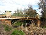 |
| 9/2/015/0019 | 11 Berg Street, Villiersdorp | Villiersdorp | Caledon | 33°59′19″S 19°17′20″E / 33.988644°S 19.288825°E |
| ||
| 9/2/015/0020 | Mill Street Conservation Area, Caledon | Caledon | Caledon | Pending Desig. |
| ||
| 9/2/015/0021 | Van Doorn's House, 13 Station Road, Caledon | Caledon | Caledon | Pending Declaration |
| ||
| 9/2/015/0022 | GREYTON MUNICIPAL AREA, CALEDON DISTRICT, GENERAL | Greyton | Caledon |
| |||
| 9/2/015/0023 | 20 Mill Street, Caledon | Caledon | Caledon | Pending Declaration |
| ||
| 9/2/015/0024 | Hassner's Pyramid Tomb, Town Commonage, Caledon | Caledon | Caledon | Pending Cons Area |
| ||
| 9/2/015/0025 | 3 Caledon Street, Villiersdorp | Villiersdorp | Caledon | 33°59′40″S 19°17′43″E / 33.994421°S 19.295178°E |
| ||
| 9/2/015/0026 | VILLIERSDORP MUNICIPAL AREA, CALEDON DISTRICT, GENERAL | Villiersdorp | Caledon |
| |||
| 9/2/015/0027 | The Post House, Main Road, Greyton | The Post House is one of the earliest buildings in Greyton, being constructed in 1860.
The local Post Office was housed in a part of the building. It now serves as a country hotel. It is a fine example of modest village architecture. |
Greyton | Caledon | Provincial Heritage Site | 34°03′27″S 19°36′56″E / 34.057420°S 19.615460°E |  |
| 9/2/015/0028 | Zeekoekraal, Villiersdorp, Caledon District | Villiersdorp | Caledon |
| |||
| 9/2/015/0029 | Mill Restaurant & Art Gallery, 25 Mill Street, Caledon | Caledon | Caledon |
| |||
| 9/2/015/0030 | GRABOUW MUNICIPAL AREA, GENERAL | Grabouw | Caledon |
| |||
| 9/2/015/0031 | Homestead, Bo-Radyn, Caledon District | The historic Cape Dutch farmhouse, Bo-Radyn, was built in 1777.
The fine pilaster front gable, with its triangular pediment, was however erected about 1836, probably by the owner, Daniel du Toit Sr.
|
Caledon | Provincial Heritage Site | 34°13′53″S 19°25′31″E / 34.231406°S 19.425244°E |
| |
| 9/2/015/0032 | Holy Trinity Church, Prince Alfred Street, Caledon | This church was designed by Sophie Gray.
She was not an architect but the clean lines and simplicity of design make it a most attractive.
building.
She maintained that churches were built for worship and not for beauty and in this church she seemed to hav
|
Caledon | Caledon | Provincial Heritage Site | 34°13′54″S 19°25′39″E / 34.231622°S 19.427479°E |  |
| 9/2/015/0033 | 14 Main Road, Greyton | Previous use: residential.
|
Greyton | Caledon | Provincial Heritage Site | 34°03′06″S 19°36′21″E / 34.051647°S 19.605740°E |  |
| 9/2/015/0034 | Greyton Lodge, 46 Main Road, Greyton, Caledon District | Greyton | Caledon | 34°02′51″S 19°36′40″E / 34.047460°S 19.611192°E |
| ||
| 9/2/015/0035 | Rock Martin Shelter, Kanonberg, Caledon District | Kanonberg | Caledon |
| |||
| 9/2/015/0036 | Blaas 'n Bietjie, Betty's Bay | This property was bought in 1961 by Dr H.F. Verwoerd, the former Prime Minister.
The house was planned by Dr Verwoerd himself in the modern style.
The garage and a milkwood thicket are situated on the same erf.
|
Betty's Bay | Caledon | Provincial Heritage Site | 34°21′10″S 18°55′37″E / 34.352670°S 18.926858°E |
|
| 9/2/015/0037 | KLEINMOND MUNICIPAL AREA, CALEDON DISTRICT, GENERAL | Kleinmond | Caledon |
| |||
| 9/2/015/0038 | Town Hall, Plein Street, Caledon | Fine double storey building with tiled roof and facades in Church Street and Main Road.
The Town Hall, facing Church Street, has an ornate ventilating turret in the centre of the roof, and two projecting gables.
The gables have corner quoins and a
|
Caledon | Caledon | Provincial Heritage Site | 34°13′55″S 19°25′44″E / 34.231981°S 19.428820°E |  |
| 9/2/015/0039 | 1 Caledon Street, Villiersdorp, Caledon District | Caledon | Caledon | 33°59′40″S 19°17′42″E / 33.994478°S 19.294884°E |
| ||
| 9/2/015/0040 | CALEDON MAGISTERIAL DISTRICT, GENERAL | Caledon | Caledon |
| |||
| 9/2/015/0041 | Wolwekloof, Caledon District | Caledon | Caledon | Pending Declaration |
| ||
| 9/2/015/0042 | Radyn, Caledon District | Caledon | Caledon | Pending Declaration |
| ||
| 9/2/015/0043 | BETTY'S BAY MUNICIPAL AREA, CALEDON DISTRICT, GENERAL | Betty's Bay | Caledon |
| |||
| 9/2/015/0044 | Caledon Museum, 11 constitution Street, Caledon | Caledon | Caledon | 34°13′47″S 19°25′47″E / 34.229769°S 19.429820°E |
| ||
| 9/2/015/0045 | "Sterhuis", Ou Werf, Caledon District | Caledon | Caledon |
| |||
| 9/2/015/0046 | Scandinavian Timber House, Elgin, Caledon District | Elgin | Caledon |
| |||
| 9/2/015/0047 | RIVIERSONDEREND MUNICIPAL AREA, GENERAL | Riviersonderend | Caledon |
| |||
| 9/2/015/0048 | Compagnes Drift, Bot River, Caledon District | Bot River | Caledon | 34°13′36″S 19°12′22″E / 34.226701°S 19.206099°E |
| ||
| 9/2/015/0049 | The Oaks, Farm 145, Caledon District | Caledon | Caledon | 34°05′43″S 19°41′43″E / 34.095355°S 19.695410°E |
| ||
| 9/2/015/0050 | MYDDLETON LOCAL AREA, GENERAL | Myddleton | Caledon |
| |||
| 9/2/015/0051 | Stony Point, Betty’s Bay, Caledon District | Betty's Bay | Caledon | 34°22′17″S 18°53′35″E / 34.371444°S 18.892971°E |
| ||
| 9/2/015/0052 | Drayton, Caledon District | Caledon | Caledon | 34°13′33″S 19°31′57″E / 34.225834°S 19.532521°E |
| ||
| 9/2/015/0053 | Teslaarsdal, Caledon District | Caledon | Caledon |
| |||
| 9/2/015/0054 | 5 Max Harris Street, Grabouw | Grabouw | Caledon | Register | 34°09′08″S 19°01′22″E / 34.152155°S 19.022707°E |  |
References
- ↑ "Western Cape Provincial Heritage Sites (previously National Monuments)" (PDF). 19 September 2002. Retrieved 2013-01-28.
| Wikimedia Commons has media related to Cultural heritage monuments in Caledon, Western Cape. |
Lists of South African Heritage Resources | ||||||||||||||||||||||||||||||||||||
|---|---|---|---|---|---|---|---|---|---|---|---|---|---|---|---|---|---|---|---|---|---|---|---|---|---|---|---|---|---|---|---|---|---|---|---|---|
| SAHRA Heritage sites |
| |||||||||||||||||||||||||||||||||||
| World heritage sites | ||||||||||||||||||||||||||||||||||||