Richtersveld
| Richtersveld Cultural and Botanical Landscape | |
|---|---|
| Name as inscribed on the World Heritage List | |
 Richtersveld-Nationalpark, Northern Cape | |
| Type | Cultural |
| Criteria | iv, v |
| Reference | 1265 |
| UNESCO region | Africa |
| Inscription history | |
| Inscription | 2007 (31st Session) |
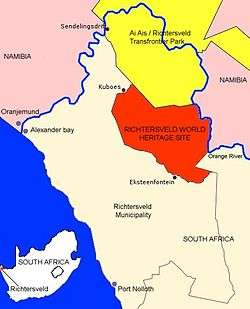
The Richtersveld is a mountainous desert landscape characterised by rugged kloofs and high mountains, situated in the north-western corner of South Africa’s Northern Cape province. It is full of changing scenery from flat, sandy, coastal plains, to craggy sharp mountains of volcanic rock and the lushness of the Orange River, which forms the border with neighbouring Namibia. The area ranges in altitude from sea level, to 1,377 m (4,518 ft) at Cornellberg.
Located in South Africa's northern Namaqualand, this arid area represents a harsh landscape where water is a great scarcity and only the hardiest of lifeforms survive. Despite this, the Richtersveld is regarded as the only Arid Biodiversity Hotspot on Earth, with an astonishing variety of plant, bird and animal life (much of which is endemic).
Part of the area is inscribed on UNESCO's World Heritage List due to its cultural values, but remains a favourite amongst nature travellers to South Africa, the landscape is sometimes described as "martian". Though barren and desolate at first glance, closer examination reveals the area to be rich in desert lifeforms, with an array of unique species specially adapted for survival.
Temperatures are extreme, and in summer can reach over 50 °C (122 °F). Rain is a very rare event.
The northern part of the area was proclaimed as a National Park in 1991 after 18 years of negotiation with the local community, who continue to live and graze their livestock in the area. It has an area of 1,624.45 square kilometres (627.20 sq mi).
In June 2007, the "Richtersveld Cultural and Botanical Landscape", just to the south of the National Park and an area of equivalent size and beauty, was named a UNESCO World Heritage Site. Unlike the National Park, the Richtersveld Community Conservancy , which forms the core zone of the World Heritage Site, is not subject to diamond mining and is as a result the more pristine of the two areas.
Climate
The climate here is harsh with temperatures of up to 53 °C (127 °F) having been recorded in mid-summer. Nights are cool and bring with them heavy dew. This unique climate is what has fostered such a unique ecosystem.
"Malmokkies"
With water so scarce, life in the Richtersveld depends on moisture from the early morning fog. Locals call it 'Ihuries' or 'Malmokkies' and it makes survival possible for a range of small reptiles, birds and mammals.
Wildlife
The park boasts excellent bird watching opportunities, as well as a diverse range of animals including grey rhebok, duiker, steenbok, klipspringer, kudu, Hartmann's mountain zebra, baboon, vervet monkey, caracal and leopard. The threatened Richtersveld katydid is endemic to the area.
Plant life
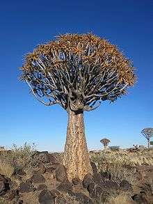
Home to c. 650 plant species, this park boasts the world’s largest diversity of succulents and represents an example of one of the most interesting mega-ecosystems in the world, the Karoo.
Odd vegetation

The area is home to a number of rather unusual plants, many of which are found nowhere else on earth. Chief among these is the "Halfmensboom" (Pachypodium namaquanum Welw.). Literally translated, this means "half-person tree" and the name comes from the tree's resemblance to the human form; its top consists of a grouping of thick, crinkled leaves, generally leaning northwards, which can make it look almost like a human head.
These trees are revered by the indigenous Nama people as the embodiment of their ancestors, half human, half plant, mourning for their ancient Namibian home.
Also found here are gnarled kokerbooms, other tall aloes, and a variety of other unusual succulents, such as Aloe pearsonii.
Culture
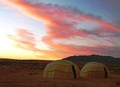
The area is inhabited by Nama and other peoples. The local community, which owns the entire area, manages the National Park in conjunction with South African National Parks and is entirely responsible for management of the World Heritage Site. Both areas are used by traditional nomadic/transhumance herders to practice their ancient lifestyle and culture. It is the last place where the traditional way of life of the KhoiKhoi (of whom the Nama are the largest surviving clan) who once occupied the entire south-western part of Africa, survives to any great extent. The World Heritage Site is declared under the cultural criteria of the World Heritage Convention although it is recognised that the cultural values of the community and their continued existence are intrinsically connected to the environment.[1]
See also
| Wikimedia Commons has media related to Richtersveld-Nationalpark. |
References
- ↑ "Richtersveld Cultural and Botanical Landscape". UNESCO. Retrieved 27 December 2012.
External links
- Richtersveld National Park and the Orange River
- Ai-|Ais/Richtersveld Transfrontier National Park
- The Richtersveld Community Conservancy, core of the World Heritage Site
- A mini travel portal for those considering to visit the Richtersveld
- The Richtersveld Municipality website
For official site names, see each article or the List of World Heritage Sites in South Africa. | ||
| ||
Coordinates: 28°17′24″S 17°08′11″E / 28.29000°S 17.13639°E