List of crossings of the Shannon
This is a list of crossings of the Shannon river, in Ireland (including bridges, tunnels, ferries and fords), from its source in the Shannon Pot to the Shannon Estuary where the river widens before it flows into the Atlantic Ocean. Bridges not primarily intended for public use but which have limited access (generally only in the daytime and only for bicycle and foot traffic) are not included.
- This transport-related list is incomplete; you can help by expanding it.
Crossings
In order, moving downstream:
| Crossing | Date | Coordinates | Heritage status |
Locality | Notes | Image |
|---|---|---|---|---|---|---|
| The source of the River Shannon | 54°14′05″N 7°55′08″W / 54.23475°N 7.919°W | - | Shannon Pot | Included for completeness | .jpg) | |
| Bradán Feasa footbridge[1][2][3] | 54°14′05″N 7°55′10″W / 54.2346°N 7.9195°W | - | Shannon Pot, County Cavan | Footbridge, built by the OPW, which crosses the infant Shannon about 20 meters downstream from the Shannon Pot | ||
| Dowra bridge | 1862[4] | 54°11′23″N 8°00′51″W / 54.1896°N 8.0141°W | - | Dowra, County Cavan | Last crossing above Lough Allen. Carries the R200 between Counties Cavan and Leitrim. | 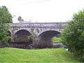 |
| Bellintra bridge[5] | 54°03′40″N 8°03′35″W / 54.0610°N 8.0598°W | - | Derrynadooey, County Roscommon[5] | First crossing below Lough Allen. Carries a local road (L33783 off the R280) between Counties Roscommon and Leitrim. Above sluice gates operated by the ESB Group.[5] | ||
| R280 Bridge | 54°03′18″N 8°04′05″W / 54.0549°N 8.0680°W | - | Aghafin, County Roscommon/Mahanagh, County Leitrim | Carries the R280 between Counties Roscommon and Leitrim. | ||
| Battlebridge | 53°59′47″N 8°04′43″W / 53.9964°N 8.0786°W | - | Battlebridge, County Roscommon/Drumhierny, County Leitrim | Carries the R284 between Counties Roscommon and Leitrim. | ||
| Carrick Bridge | 53°56′35″N 8°05′45″W / 53.943°N 8.0958°W | - | Carrick-on-Shannon, County Leitrim | Carries the M4/N4 from through Carrick-on-Shannon crossing between Roscommon and Leitrim. | ||
| Lough Tap Railway Bridge[6] | 53°54′22″N 7°59′34″W / 53.906°N 7.9928°W | - | Lough Tap, Border of Co. Roscommon & Leitrim | Carries the Dublin–Sligo railway line between Counties Roscommon and Leitrim over Lough Tap. Links Dromod and Carrick-on-Shannon railway stations. | ||
| X X | ||||||
| Jamestown Bridge | 1800s | 53°55′25″N 8°01′47″W / 53.9235°N 8.0298°W | - | East of Jamestown, County Leitrim | First of two bridges carrying the L3656 from Jamestown to Drumsna through the northern tip of County Roscommon | |
| Drumsna Bridge | 1800s | 53°55′29″N 8°00′41″W / 53.9248°N 8.0113°W | - | Southwest of Drumsna, County Leitrim | Second of two bridges carrying the L3656 from Jamestown to Drumsna through the northern tip of County Roscommon[7] | 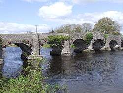 |
| X X | ||||||
| Jamestown Canal Bridge | c.1850 | 53°49′57″N 7°55′07″W / 53.8326°N 7.9187°W | - | Corry, Co. Roscommon | Carries the L1405 from the L3656 Jamestown/Drumsna Road towards Strokestown | |
| Roosky Bridge | 1840-1850 | 53°49′57″N 7°55′07″W / 53.8326°N 7.9187°W | - | Roosky, Co. Roscommon | Carries the R371 between Counties Roscommon and Leitrim through Roosky. | 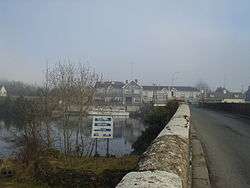 |
| Tarmonbarry Bridge | 53°44′32″N 7°55′03″W / 53.7421°N 7.9176°W | - | East of Tarmonbarry, Co. Roscommon | Carries the N5 between Counties Roscommon and Longford. | ||
| Bord na Móna rail bridge | 53°42′02″N 7°59′05″W / 53.7006°N 7.9848°W | - | c.2 km North of Lough Ree Power Station, Lanesboro | Private. Narrow-gauge rail line, used to transport peat from bog to nearby power station. | ||
| Lanesboro bridge | 1971 | 53°40′27″N 7°59′33″W / 53.6743°N 7.9926°W | - | Lanesboro | Last crossing above Lough Ree. Links the twin towns of Lanesborough, on the County Longford (east) side and Ballyleague, on the County Roscommon (west) side of the river. | |
| N6 New Shannon Bridge - Athlone bypass[8][lower-alpha 1] | 1991[8] | 53°25′56″N 7°57′21″W / 53.4322°N 7.9558°W | - | North of Athlone | First crossing below Lough Ree. Carries the M6/N6 Athlone bypass. | |
| White Bridge[9][10][11] | 1850 [12] | 53°25′38″N 7°56′45″W / 53.4272°N 7.9459°W | - | Athlone | c.200 m west of Athlone railway station. The Dublin–Westport/Galway railway line diverges c.200m west of the bridge | 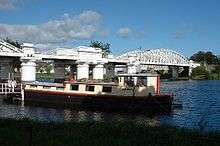 |
| Road Bridge Athlone | 53°25′25″N 7°56′31″W / 53.4237°N 7.9419°W | - | Athlone | Carries Custume Place (the R446, the old N6 Dublin - Galway Road). Links Athlone Castle and St. Peter and Paul's Church to the Eastern/Leinster side of Athlone | ||
| bridge to Long Island (West bank only) | 53°16′47″N 8°03′03″W / 53.2797°N 8.0509°W | - | Long Island, Leamore, County Roscommon | Private local road. Links Long Island to the west bank. | ||
| Shannonbridge | 53°16′47″N 8°03′03″W / 53.2797°N 8.0509°W | - | Shannonbridge, County Offaly | Carries R357 from Shannonbridge to County Roscommon | ||
| Banagher bridge | 1841–1843 (widened 1971) | 53°11′36″N 7°59′33″W / 53.1934°N 7.9926°W | - | Northwest of Banagher | Carries the R356 between Counties Offaly and Galway. | 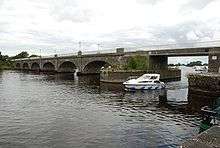 |
| Portumna bridge | 1911 | 53°05′28″N 8°11′38″W / 53.0911°N 8.1938°W | - | East of Portumna | Last crossing above Lough Derg. Carries the N65 between Counties Tipperary and Galway. Connects Lehinch island to both banks. |  |
| Killaloe Bridge | c.1770[13] | 52°48′29″N 8°26′21″W / 52.808115°N 8.439110°W | - | Between Ballina and Killaloe | First crossing below Lough Derg. A single lane road bridge linking Counties Tipperary and Clare |  |
| X X | ||||||
| O'Briensbridge (Shannon) | 1780 - 1810[14] | 52°45′08″N 8°29′55″W / 52.7522°N 8.4985°W | - | East of the village of O'Briensbridge, Co. Clare | Carries the R466 from O'Briensbridge, Co. Clare into Montpelier, County Limerick |  |
| X X | ||||||
| The Living Bridge | 2007 | 52°40′36″N 8°34′13″W / 52.6768°N 8.5702°W | - | University of Limerick main campus | Pedestrian bridge. Links the main campus on the south bank (in County Limerick) to student residences on the north bank (in County Clare). | 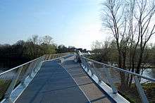 |
| University Bridge | 2004 | 52°40′41″N 8°34′35″W / 52.678°N 8.5763°W | - | University of Limerick main campus | Links the main campus on the south bank (in County Limerick) to student residences on the north bank (in County Clare). | |
| X X | ||||||
| bridge at Coollisteige | 52°43′59″N 8°32′00″W / 52.7331°N 8.5333°W | - | Coollisteige, County Clare | Close to the Ardnacrusha canal (which is (c.100m to the north)). | ||
| bridge at Gillogue | 52°41′09″N 8°34′19″W / 52.6859°N 8.572°W | - | East of Gillogue office park, County Clare | Narrow single lane stone bridge. Unmarked lane. | ||
| Athlunkard Bridge | 1825 - 1830[15] | 52°40′52″N 8°36′36″W / 52.6812°N 8.6099°W | - | Corbally, Co. Limerick | Carries the R463 between Corbally Road on the outskirts of Limerick city and Athlunkard Avenue in Corbally, County Clare. | |
| X X | ||||||
| canal bridge, O'Briensbridge | 52°45′11″N 8°30′24″W / 52.753°N 8.5068°W | - | West of the village of O'Briensbridge, Co. Clare | Carries the R466 from O'Briensbridge into Bridgetown | ||
| Ardnacrusha power plant | 52°42′20″N 8°36′44″W / 52.705594°N 8.612313°W | - | Southwest of Ardnacrusha within County Clare approximately 1.5 miles (2.4 km) from the Limerick border | ESB Group private property. It is Ireland's largest river hydroelectric scheme. | 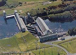 | |
| X X | ||||||
| Sylvester O'Halloran Bridge | 52°39′55″N 8°37′26″W / 52.6653°N 8.6238°W | - | Limerick | Pedestrian Bridge |  | |
| X X | ||||||
| Thomand Bridge | 52°40′13″N 8°37′38″W / 52.670304°N 8.627174°W | - | Limerick | Links Castle Street on King's Island to High Road on the Northwest bank | ||
| Shannon Bridge | 52°39′44″N 8°38′06″W / 52.6623°N 8.6351°W | - | Limerick | R527, last bridge in the city and over the Shannon | ||
| Limerick Tunnel[16] | 52°39′19″N 8°41′12″W / 52.6552°N 8.6868°W | - | Limerick | Carries the N18, Western part of the Limerick Southern Ring Road.[16] | ||
| Shannon Ferry | 1969[17] | 52°36′53″N 9°22′49″W / 52.6147°N 9.3804°W | - | Killimer, County Clare - Tarbert Island, County Kerry | Ro-ro ferry. Part of the N67 |  |
| Greenway Bridge Athlone [lower-alpha 2] | 2017 onwards[12][18] | 53°25′26″N 7°56′35″W / 53.423971°N 7.942938°W[12] | - | Luan Gallery, Athlone | Cycle/Pedestrian Bridge. Will carry the Dublin-Galway Greenway from the Radisson Hotel to the Luan Gallery.[12] | |
References
- ↑ "NB The Puzzler Blog". 6 January 2013. Archived from the original on 22 August 2014. Retrieved 20 August 2014.
- ↑ Biege, Bernd. "The Mighty Shannon's Humble Origins". About.com. Archived from the original on 12 April 2016. Retrieved 12 April 2016.
- ↑ "The Shannon Pot". Castlebar.ie. 15 September 2014. Archived from the original on 12 April 2016.
- ↑ ManorHamilton.ie|Dowra
- 1 2 3 ROSCOMMON COUNTY COUNCIL PLANNING APPLICATIONS
- ↑ "Lough Tap railway bridge". IrishWaterwaysHistory.com. 18 October 2010. Archived from the original on 28 September 2013. Retrieved 8 March 2016.
- ↑ http://www.buildingsofireland.ie/niah/search.jsp?type=record&county=LE®no=30815007
- 1 2 3 "Bypass bridge to be renamed Cumann na mBan Bridge". Athlone Advertiser. 2 April 2015. Retrieved 2 April 2015.
- ↑ "White Bridge improvements welcome - O'Rourke". Westmeath Independent. 19 November 2015. Archived from the original on 11 December 2015. Retrieved 11 December 2015.
- ↑ Kelly, Tom (6 July 2011). "Protester's Athlone railway bridge demonstration is criticised". Westmeath Independent. Archived from the original on 19 November 2015. Retrieved 19 November 2015.
- ↑ Coghlan, Finian (2 August 2013). "White Bridge boat crash driver gets trial date". Athlone Advertiser. Archived from the original on August 6, 2013.
- 1 2 3 4 5 Daly, Maria (9 October 2014). "Council confirm plans for new towncentre bridge as part of cycleway". Athlone Advertiser. Retrieved 9 October 2014.
- ↑ http://www.buildingsofireland.ie/niah/search.jsp?type=record&county=TN®no=22306005
- ↑ http://www.buildingsofireland.ie/niah/search.jsp?type=record&county=LC®no=21900107
- ↑ http://www.buildingsofireland.ie/niah/search.jsp?type=record&county=LI®no=21502002
- 1 2 "Frequently Asked Questions". Limerick Tunnel. 2010. Archived from the original on 7 October 2010.
- ↑ http://www.irishtimes.com/business/sectors/transport-and-tourism/shannon-ferry-group-goes-into-the-red-1.531910
- ↑ Grace, Robert (10 December 2015). "Councillors welcome latest proposed design for Athlone's cycleway bridge". Athlone Advertiser. Archived from the original on 11 December 2015.
This article is issued from Wikipedia - version of the 9/28/2016. The text is available under the Creative Commons Attribution/Share Alike but additional terms may apply for the media files.