List of airports in Bulgaria

Provinces of Bulgaria (click for larger image)

This is a list of airports in Bulgaria. It is a partial list of public active aerodromes (airports and airfields), grouped by type and sorted by location.

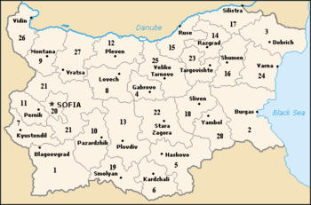
The Republic of Bulgaria is a country in the Balkans in southeastern Europe. It borders five other countries: Romania to the north (mostly along the River Danube), Serbia and the Republic of Macedonia to the west, and Greece and Turkey to the south. The Black Sea defines the extent of the country to the east. The country's capital city is Sofia. Bulgaria is divided into 28 provinces which are subdivided into 260 municipalities.

Passenger statistics

Bulgarian airports with number of passengers served in 2014 & 2015:

Rank Airport City IATA / ICAO 2014 2015 Change
1. Sofia Airport Sofia SOF / LBSF 3,815,158 4,088,943 Increase 7.2%
2. Burgas Airport Burgas BOJ / LBBG 2,522,319 2,360,320 Decrease 6.7%
3. Varna Airport Varna VAR / LBWN 1,387,494 1,398,694 Increase 0.8%
4. Plovdiv Airport Plovdiv PDV / LBPD 103,535 103,300 Decrease 0.2%
5. Gorna Oryahovitsa Airport Gorna Oryahovitsa GOZ / LBGO N/A N/A N/A
TOTAL 7,836,555 7,951,257 Increase 1.4%

Airports

Airport names shown in bold indicate the airport has scheduled service on commercial airlines.

City served Province ICAO IATA DAFIF Airport name Coordinates
ÿ Airports[1] ÿ ÿ ÿ ÿ ÿ ÿ
Burgas / Sarafovo Burgas LBBG BOJ Burgas Airport 42°34′10″N 027°30′54″E / 42.56944°N 27.51500°E / 42.56944; 27.51500 (Burgas Airport)
Gorna Oryahovitsa Veliko Tarnovo LBGO GOZ Gorna Oryahovitsa Airport 43°09′05″N 025°42′46″E / 43.15139°N 25.71278°E / 43.15139; 25.71278 (Gorna Oryahovitsa Airport)
Plovdiv / Krumovo Plovdiv LBPD PDV Plovdiv Airport 42°04′04″N 024°51′03″E / 42.06778°N 24.85083°E / 42.06778; 24.85083 (Plovdiv Airport)
Rousse (Ruse) / Shtraklevo Rousse LBRS ROU Ruse Airport (not operational) 43°41′41″N 026°03′24″E / 43.69472°N 26.05667°E / 43.69472; 26.05667 (Ruse Airport)
Sofia Sofia-oblast LBSF SOF Sofia Airport 42°41′42″N 023°24′22″E / 42.69500°N 23.40611°E / 42.69500; 23.40611 (Sofia Airport)
Stara Zagora Stara Zagora LBSZ SZR Stara Zagora Airport (not operational) 42°22′36″N 025°39′18″E / 42.37667°N 25.65500°E / 42.37667; 25.65500 (Stara Zagora Airport)
Varna / Aksakovo Varna LBWN VAR Varna Airport 43°13′55″N 027°49′30″E / 43.23194°N 27.82500°E / 43.23194; 27.82500 (Varna Airport)
ÿ Certified airfields[2] ÿ ÿ ÿ ÿ ÿ ÿ
Balchik (Balchic) Dobrich LBWB LB25 Balchik Airfield 43°25′28″N 028°10′51″E / 43.42444°N 28.18083°E / 43.42444; 28.18083 (Balchik Airfield)
Bohot Pleven Bohot Airfield 43°18′23″N 024°41′29″E / 43.30639°N 24.69139°E / 43.30639; 24.69139 (Bohot-LM Airfield)
Grivitsa (Grivitza, Grivica) Pleven Grivitza Airfield 43°24′00″N 024°46′00″E / 43.40000°N 24.76667°E / 43.40000; 24.76667 (Grivitza Airfield)
Dolna Banya (Dolna Bania) Sofia LBDB Dolna Bania Airfield 42°18′31″N 023°49′13″E / 42.30861°N 23.82028°E / 42.30861; 23.82028 (Dolna Bania Airfield)
Erden / Bojchinovci Montana LBED Erden Airfield 43°29′57″N 023°18′17″E / 43.49917°N 23.30472°E / 43.49917; 23.30472 (Erden Airfield)
Izgrev / Kalimantsi Varna Izgrev Airfield 43°16′38″N 027°42′07″E / 43.27722°N 27.70194°E / 43.27722; 27.70194 (Izgrev Airfield)
Ihtiman Sofia LBHT Ihtiman Airfield 42°25′19″N 023°46′02″E / 42.42194°N 23.76722°E / 42.42194; 23.76722 (Ihtiman Airfield)
Kaynardzha Silistra Kaynardzha Airfield 43°58′13″N 027°28′10″E / 43.97028°N 27.46944°E / 43.97028; 27.46944 (Kaynardzha Airfield)
Lesnovo / Elin Pelin Sofia LBLS Lesnovo Airfield 42°38′04″N 023°38′47″E / 42.63444°N 23.64639°E / 42.63444; 23.64639 (Lesnovo Airfield)
Polikraishte Veliko Tarnovo Polikraishte Airfield 43°11′57″N 025°38′27″E / 43.19917°N 25.64083°E / 43.19917; 25.64083 (Polikraishte Airfield)
Primorsko Burgas LBPR Primorsko Airfield 42°15′33″N 027°42′11″E / 42.25917°N 27.70306°E / 42.25917; 27.70306 (Primorsko Airfield)
ÿ Other airfields ÿ ÿ ÿ ÿ ÿ ÿ
Kazanlak Stara Zagora LBKA Kalvacha Airport 42°35′41″N 025°25′13″E / 42.59472°N 25.42028°E / 42.59472; 25.42028 (Kalvacha Airport)
Haskovo Haskovo HKV LB26 Malevo Airport 41°52′18″N 025°36′17″E / 41.87167°N 25.60472°E / 41.87167; 25.60472 (Malevo Airport)
ÿ Military airports ÿ ÿ ÿ ÿ ÿ ÿ
Bezmer Yambol LBIA JAM LB44 Bezmer Air Base 42°27′17″N 026°21′08″E / 42.45472°N 26.35222°E / 42.45472; 26.35222 (Bezmer Air Base)
Buhovtsi (Bukhovtsi) Targovishte LBTG TGV Buhovtsi Airfield (Targovishte Airport) 43°18′24″N 026°42′00″E / 43.30667°N 26.70000°E / 43.30667; 26.70000 (Buhovtsi Airfield)
Dobroslavtsi Sofia-oblast LBSD LB20 Dobroslavtsi Air Base (Kumaritsa) 42°48′44″N 023°17′58″E / 42.81222°N 23.29944°E / 42.81222; 23.29944 (Dobroslavtsi Air Base)
Dolna Mitropolia Pleven LBPL PVN LB41 Dolna Mitropolia Air Base 43°27′05″N 024°30′10″E / 43.45139°N 24.50278°E / 43.45139; 24.50278 (Dolna Mitropolia Air Base)
Gabrovnitsa Montana LBMG LB15 Gabrovnitsa Air Base 43°32′39″N 023°16′21″E / 43.54417°N 23.27250°E / 43.54417; 23.27250 (Gabrovnitsa Air Base)
Graf Ignatievo Plovdiv LBPG LB21 Graf Ignatievo Air Base 42°17′25″N 024°42′50″E / 42.29028°N 24.71389°E / 42.29028; 24.71389 (Graf Ignatievo Air Base)
Ravnets (Ravnetz) Burgas LBBR Ravnets Air Base 42°31′37″N 027°16′05″E / 42.52694°N 27.26806°E / 42.52694; 27.26806 (Ravnets Air Base)
Silistra Silistra LBSS SLS LB12 Silistra Airfield (Polkovnik Lambrinovo) 44°03′18″N 027°10′43″E / 44.05500°N 27.17861°E / 44.05500; 27.17861 (Silistra Airfield)
Sliven Sliven LBSL LB17 Sliven Airfield 42°38′46″N 026°21′33″E / 42.64611°N 26.35917°E / 42.64611; 26.35917 (Sliven Airfield)
Haskovo Haskovo LBHS LB14 Uzundzhovo Air Base 41°58′34″N 025°35′23″E / 41.97611°N 25.58972°E / 41.97611; 25.58972 (Uzundzhovo Air Base)
Vidin Vidin LBVD VID LB40 Vidin Airfield 44°01′20″N 022°48′58″E / 44.02222°N 22.81611°E / 44.02222; 22.81611 (Vidin Airfield)

See also

References

and Herzegovina Airport records for Bosnia and Herzegovina at Landings.com. Retrieved 2013-09-03

Footnotes

  1. "Airports". Bulgarian Civil Aviation Administration. Retrieved 12 June 2009.
  2. "Certified Airfields". Bulgarian Civil Aviation Administration. Retrieved 12 June 2009.


This article is issued from Wikipedia - version of the 5/30/2016. The text is available under the Creative Commons Attribution/Share Alike but additional terms may apply for the media files.