List of Alamannic pagi
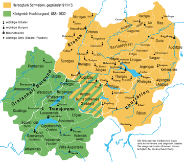
Map of Alamannia and Upper Burgundy in the 10th to 11th centuries.
The following is a list of pagi (the Latin term glossing Old High German gowe, corresponding to English shire) of early medieval Alamannia under Frankish suzerainty. Each pagus was ruled by a count (Gaugraf) who in turn responded to the duke of Alamannia. Many of the names of these territories survive in modern toponymy.
- Alba (Albuch)
- Albegowe (Allgäu)
- Alpegowe (modern Albgau)
- Argungowe (at the Argen River)
- Augestigowe (surrounding Augsburg)
- Augestigowe (the territory surrounding Augst)
- Brisigowe (modern Breisgau)
- Britgewe
- Duria (Duriagau)
- Filiwigawe (Filsgau, named for the Fils River)
- Folcholtespara (Folcholtsbaar)
- Hegowe (Hegau)
- Illargowe (named for the Iller)
- Keltinstein (between Geltnach and Wertach, tributaries of the Lech)
- Linzgowe (Linzgau)
- Mortunova, the later Ortenau
- Nekargowe (named for the Neckar)
- Nordgowe (Nordgau, Alsace)
- Perahtoltaspara (Berchtoldsbaar)
- Rammegowe (Rammachgau)
- Trachgowe (Drachgau, near Schwäbisch Gmünd)
- Turgowe (modern Thurgau, named for the Thur River)
- Rezia (Ries, ultimately from the name of the Roman province of Raetia)
- Suntgowe (Sundgau, Alsace)
- Swiggerstal (the modern Ermstal)
The territory between Alamannia and Upper Burgundy was known as Argowe (modern Aargau, named for the Aare river). The pertinence of this territory to either Alamannia or Upper Burgundy was disputed.
The county of Raetia was absorbed into Alamannia in the early 10th century. It comprised the Ringowe (Rheingau, named for the Rhine) and Retia proper.
Counties of the kingdom of Upper Burgundy:
- Burgundy (Franche-Comté)
- Portuensis (Portois)
- Amosensis
- Scudinga
- Warascum or Varesco, Warasgow
- Alsgowe (Elsgau)
- Transjurania
- Sorengowe (Sornegau)
- Bargensis (Bargengau)
- Wisliaeensis (the territory surrounding Avenches, German Wiflisburg)
- Lausonensis (Lausanne)
- Equestricus (Nyon, lat. Colonia Iulia Equestris)
- Genevensis (Geneva)
- Albanensis (Albanais)
- Falcinensis (Faucigny)
- Caputlacensis (Chablais)
- Vallensis (Valais)
- Ausicensis (upper Saane valley)
- Ufegowe (Ufgau in what is now the Lake Thun region of the Bernese Oberland, not to be confused with Ufgau (Baden))
References
- G. Droysen: Allgemeiner Historischer Handatlas. Bielefeld / Leipzig, 1886, 22f.
This article is issued from Wikipedia - version of the 8/28/2016. The text is available under the Creative Commons Attribution/Share Alike but additional terms may apply for the media files.