Linden, Tennessee
| Linden, Tennessee | |
|---|---|
| Town | |
|
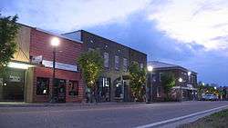
Linden courthouse square | |
 Linden, Tennessee  Linden, Tennessee Location within the state of Tennessee | |
| Coordinates: 35°36′44″N 87°50′30″W / 35.61222°N 87.84167°WCoordinates: 35°36′44″N 87°50′30″W / 35.61222°N 87.84167°W | |
| Country | United States |
| State | Tennessee |
| County | Perry |
| Incorporated | 1850[1] |
| Named for | "Hohenlinden", poem by Thomas Campbell[2] |
| Area | |
| • Total | 1.0 sq mi (2.5 km2) |
| • Land | 1.0 sq mi (2.5 km2) |
| • Water | 0.0 sq mi (0.0 km2) |
| Elevation | 568 ft (173 m) |
| Population (2010) | |
| • Total | 908 |
| • Density | 1,040.9/sq mi (401.9/km2) |
| Time zone | Central (CST) (UTC−6) |
| • Summer (DST) | CDT (UTC−5) |
| ZIP code | 37096 |
| Area code | 931 |
| FIPS code | 47-42720[3] |
| GNIS feature ID | 1291316[4] |
| Website | lindentn.org |
Linden is a town in and the county seat of Perry County, Tennessee, United States.[5] The population was 1,015 at the 2000 census and 908 at the 2010 showing a loss of 107. Linden was officially incorporated in 1850.[6]
Linden is served by Perry County Airport, located 3.5 miles to the southwest.
Geography
Linden is located at 35°36′44″N 87°50′30″W / 35.61222°N 87.84167°W (35.612168, -87.841601).[7]
According to the United States Census Bureau, the town has a total area of 1.0 square mile (2.6 km2), all of it land.
Demographics
| Historical population | |||
|---|---|---|---|
| Census | Pop. | %± | |
| 1870 | 149 | — | |
| 1880 | 189 | 26.8% | |
| 1890 | 330 | 74.6% | |
| 1930 | 539 | — | |
| 1940 | 641 | 18.9% | |
| 1950 | 854 | 33.2% | |
| 1960 | 1,086 | 27.2% | |
| 1970 | 1,062 | −2.2% | |
| 1980 | 1,087 | 2.4% | |
| 1990 | 1,099 | 1.1% | |
| 2000 | 1,015 | −7.6% | |
| 2010 | 908 | −10.5% | |
| Est. 2015 | 908 | [8] | 0.0% |
| Sources:[9][10] | |||
As of the census[3] of 2000, there were 1,015 people, 400 households, and 233 families residing in the town. The population density was 1,040.9 people per square mile (399.9/km²). There were 461 housing units at an average density of 472.8 per square mile (181.6/km²). The racial makeup of the town was 93.0%White, 5.52% African American, 0.49% Native American, 0.20% Asian, and 0.49% from two or more races. Hispanic or Latino of any race were 0.39% of the population.
There were 400 households out of which 26.3% had children under the age of 18 living with them, 44.0% were married couples living together, 12.3% had a female householder with no husband present, and 41.8% were non-families. 37.5% of all households were made up of individuals and 24.0% had someone living alone who was 65 years of age or older. The average household size was 2.25 and the average family size was 2.97.
In the town the age distribution of the population shows 22.6% under the age of 18, 6.6% from 18 to 24, 21.3% from 25 to 44, 19.6% from 45 to 64, and 30.0% who were 65 years of age or older. The median age was 45 years. For every 100 females there were 76.2 males. For every 100 females age 18 and over, there were 69.8 males.
The median income for a household in the town was $25,134, and the median income for a family was $31,000. Males had a median income of $24,500 versus $21,063 for females. The per capita income for the town was $19,410. About 16.8% of families and 23.9% of the population were below the poverty line, including 27.5% of those under age 18 and 23.1% of those age 65 or over.

Notable people
- Bob Harris (basketball) – Fort Wayne Pistons and Boston Celtics.
- Clyde Milan – An outfielder with the Washington Senators from 1907 to 1922.
- Horace Milan – a Washington Senators baseball player who played outfielder from 1915 to 1917.
References
- ↑ Tennessee Blue Book, 2005–2006, pp. 618-625.
- ↑ Larry Miller, Tennessee Place Names (Indiana University Press, 2001), p. 123.
- 1 2 "American FactFinder". United States Census Bureau. Retrieved 2008-01-31.
- ↑ "US Board on Geographic Names". United States Geological Survey. 2007-10-25. Retrieved 2008-01-31.
- ↑ "Find a County". National Association of Counties. Retrieved 2011-06-07.
- ↑ "Incorporated Municipalities" in Tennessee Blue Book, 2005–2006 edition, pages 618-625.
- ↑ "US Gazetteer files: 2010, 2000, and 1990". United States Census Bureau. 2011-02-12. Retrieved 2011-04-23.
- ↑ "Annual Estimates of the Resident Population for Incorporated Places: April 1, 2010 to July 1, 2015". Retrieved July 2, 2016.
- ↑ "Census of Population and Housing: Decennial Censuses". United States Census Bureau. Retrieved 2012-03-04.
- ↑ "Incorporated Places and Minor Civil Divisions Datasets: Subcounty Resident Population Estimates: April 1, 2010 to July 1, 2012". Population Estimates. U.S. Census Bureau. Retrieved 11 December 2013.
External links
- Town of Linden
- Town charter
- Perry County Chamber of Commerce
- US election 2016 Did 'socialism' save this US town? - BBC News
Municipalities and communities of Perry County, Tennessee, United States | ||
|---|---|---|
| City | ||
| Town | ||
| Unincorporated communities | ||