Levanto, Liguria
| Levanto | ||
|---|---|---|
| Comune | ||
| Comune di Levanto | ||
 | ||
| ||
 Levanto Location of Levanto in Italy | ||
| Coordinates: 44°10′N 9°37′E / 44.167°N 9.617°E | ||
| Country | Italy | |
| Region | Liguria | |
| Province / Metropolitan city | La Spezia (SP) | |
| Frazioni | Lizza, Lavaggiorosso, Dosso, Groppo, Montale, Vignana, Lerici, Pastine, Chiesanuova, Fontona, Legnaro, Fossato, Ridarolo | |
| Government | ||
| • Mayor | Maurizio Moggia | |
| Area | ||
| • Total | 38.0 km2 (14.7 sq mi) | |
| Elevation | 3 m (10 ft) | |
| Population (31 December 2008) | ||
| • Total | 5,597 | |
| • Density | 150/km2 (380/sq mi) | |
| Demonym(s) | Levantesi | |
| Time zone | CET (UTC+1) | |
| • Summer (DST) | CEST (UTC+2) | |
| Postal code | 19015 | |
| Dialing code | 0187 | |
| Website | Official website | |

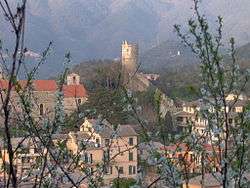
Levanto is a comune (municipality) in the province of La Spezia in the Italian region Liguria, located about 60 kilometres (37 mi) southeast of Genoa and about 20 kilometres (12 mi) northwest of La Spezia. The town is on the coast at the end of a valley, thickly wooded with olive and pine trees. The ridges on either side of the valley thrust out into the sea as the headlands of Mesco and Levanto. The municipality forms part of the coastal district known as the Comunità Montana della Riviera Spezzina, and part of its territory is included in the Cinque Terre National Park.
History
In Roman times there was already a small settlement by the name of Ceula on the hills. This constituted an important nodal point due to its location. At the beginning of the 9th century, the bell tower of the present church, the Chiesa di San Siro, served as a watchtower and as a defence against dangers from the sea. From the 13th century, however, the importance of the area began to decline – this to the advantage of Levanto itself, which was expanding by the sea.
Levanto first became the feudal stronghold of the Malaspina, before passing to the Da Passano and then, in 1229, to the Republic of Genoa. In the Middle Ages, the village became a centre of commercial activity, benefiting from maritime and overland communications, the most important of the latter being the via Francigena. In the post-Medieval period, the village saw major development with the construction of the Borgo Nuovo or Stagno on the plain of the Ghiararo. This survives today and is characterised by interesting 17th and 18th century buildings. A further phase of urban development took place at the turn of the 19th and 20th centuries with the opening of two thoroughfares, the present Corso Italia and Corso Roma. From 1950, the village experienced further growth culminating during the 1970s in the present townscape.
Main sights
- Medieval castle, built to defend the village and still in a state of perfect conservation.
- church of Sant'Andrea (Church of Saint Andrew). An example of 13th century Ligurian Gothic style with its façade decorated in black and white bands, and a magnificent rose window surmounting the main door. The chalice of emperor Henry VII is one of its treasures, and displayed only on special occasions such as the festival of the patron saint.
- Church of Santa Maria della Costa' (Church of Saint Mary of the Coast)
- Villa Agnelli. Its gardens were landscaped at the beginning of the 20th century.
- Piazza della Loggia, characterized by a 13th-century loggia, which in 2007 received from UNESCO the title of "monument being evidence of culture and peace".
- Piazza Cavour, in earlier times the inner courtyard of the Monastero delle Ordine di Santa Chiara (Monastery of the Order of St Claire). The town hall, the public library and other municipal offices are accommodated under its portico.
Culture
- Permanent exhibition of cultural artifacts
Festivals
- Festival Massimo Amfiteatrof, classical and chamber music festival dedicated to Russian born cellist Massimo Amfiteatrof. June/July - September.[1]
- Festa di San Giacomo (Feast of St James) and Festa del Mare (Festival of the Sea). 24–25 July.
- Festa di Nostra Signora della Guardia Traditional band concert. 29 August.
- Sagra del Gattafin (fried pastry stuffed with beets, onions, egg and grated cheese) in June.
- Festa Madonna del Soccorso 1–2 July in Fontona (a little village near Levanto)

References
External links
| Wikimedia Commons has media related to Levanto. |