Lesser Caucasus
| Lesser Caucasus | |
|---|---|
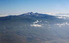 Aragats mount in Armenia | |
| Highest point | |
| Peak | Aragats [1] |
| Elevation | 4,090 m (13,420 ft) |
| Dimensions | |
| Length | 600 km (370 mi) NW-SE |
| Geography | |
 Satellite image, the snowy mountains to the south are the Lesser Caucasus | |
| Countries | |
| Range coordinates | 41°N 44°E / 41°N 44°ECoordinates: 41°N 44°E / 41°N 44°E |
| Parent range | Caucasus Mountains |
| Borders on | Greater Caucasus |
Lesser Caucasus (Armenian: Փոքր Կովկաս Pʿokʿr Kovkas, Azerbaijani: Kiçik Qafqaz Dağları, Georgian: მცირე კავკასიონი, Russian: Малый Кавказ, Turkish: Küçük Kafkasya, sometimes translated as "Caucasus Minor") is second of the two main mountain ranges of Caucasus mountains, of length about 600 km (370 mi). The western portion of the Lesser Caucasus overlaps and converges with the high plateau of Eastern Anatolia, in the far northeast of Turkey.
It runs parallel to the Greater Caucasus, at a distance averaging about 100 km (62 mi) south from Likhi Range (Georgia) and limits the Armenian Highland from the North and North-East.
It is connected to the Greater Caucasus by the Likhi Range (Georgia) and separated from it by the Kolkhida Lowland (Georgia) in the West and Kura-Aras Lowland (Azerbaijan) (by Kura River) in the East.
The highest peak is Aragats, 4,090 m (13,420 ft).[1]
The borders between Georgia, Turkey, Armenia, and Azerbaijan run through the range, although its crest does not usually define the border.
References
- 1 2 "Mount Aragats | mountain, Armenia". Encyclopedia Britannica. Archived from the original on 2016-03-08. Retrieved 2016-05-07.