Geography of Georgia (country)
| ||
| Continent | Europe / Asia | |
| Subregion | Southwest Asia / Eastern Europe | |
| Geographic coordinates | 42°00′N 43°30′E / 42.000°N 43.500°E | |
| Area | 69,875 km2 (26,979 sq mi) | |
| Coastline | 310 km | |
| Land boundaries | 1,814 km | |
| Countries bordered | Russia 894 km, Turkey 273 km, Armenia 219 km, Azerbaijan 428 km | |
| Maritime claims | 200 nmi (370.4 km; 230.2 mi) | |
| Highest point | Mount Shkhara, 5,201 m | |
| Lowest point | Bogs between Poti and Kulevi, (-1.5-2.3 m)[1] | |
| Longest river | Kura River, 1,364 km | |
| Land Use - Arable land - Permanent crops - Other | 5.76% 1.80% 92.44% (2012) | |
| Climate: | Temperate to Subtropical, warm and pleasant, Mediterranean-like on Black Sea coast | |
| Terrain: | plains, mountains, valleys | |
| Natural resources | timber, hydropower, manganese deposits, iron ore, copper, minor coal and petroleum deposits; coastal climate and soils allow for important tea and citrus growth | |
| Natural hazards | earthquakes | |
| Environmental issues | air and water pollution, soil pollution from toxic chemicals | |

The geography of Georgia describes the geographic features of Georgia, a country in the Caucasus region. Situated at the juncture of Western Asia and Eastern Europe,[2] it is bounded to the west by the Black Sea, to the north by Russia, to the south by Turkey and Armenia, and to the east by Azerbaijan. Georgia covers an area of 69,875 square kilometres (26,979 sq mi).
Location
Georgia is located in the mountainous South Caucasus region of Eurasia, straddling Western Asia and Eastern Europe[2] between the Black Sea and the Caspian Sea. Georgia's northern border with Russia roughly runs along the crest of the Greater Caucasus mountain range – a commonly reckoned boundary between Europe and Asia. In Philip Johan von Strahlenberg's 1730 definition of Europe, which was used by the Russian Tsars and which first set the Urals as the eastern border of the continent, the continental border was drawn from the Kuma-Manych Depression to the Caspian Sea, thereby including all of Georgia (and the whole of the Caucasus) in Asia.
Georgia's proximity to the bulk of Europe, combined with various cultural and political factors, has led increasingly to the inclusion of Georgia in Europe. Some sources place the country in that region;[2] as well, Georgia has joined European organizations such as the Council of Europe, and is seeking membership in NATO and accession to the European Union. Georgia is on the same parallel as Naples, Madrid, Istanbul, New York, Chicago, London, Toronto (Canada), Omaha (USA), Eureka (USA), Odate (Japan), Shenyang (China) and Tirana.
Topography

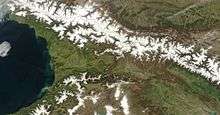
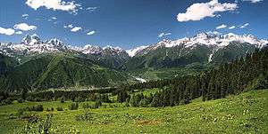
Despite its small area, Georgia has one of the most varied topographies of the former Soviet republics. Georgia lies mostly in the Caucasus Mountains, and its northern boundary is partly defined by the Greater Caucasus range. The Lesser Caucasus range, which runs parallel to the Turkish and Armenian borders, and the Surami and Imereti ranges, which connect the Greater Caucasus and the Lesser Caucasus, create natural barriers that are partly responsible for cultural and linguistic differences among regions. Because of their elevation and a poorly developed transportation infrastructure, many mountain villages are virtually isolated from the outside world during the winter. Earthquakes and landslides in mountainous areas present a significant threat to life and property. Among the most recent natural disasters were massive rock- and mudslides in Ajaria in 1989 that displaced thousands in southwestern Georgia, and two earthquakes in 1991 that destroyed several villages in northcentral Georgia and South Ossetia.
Georgia has about 25,000 rivers, many of which power small hydroelectric stations. Drainage is into the Black Sea to the west and through Azerbaijan to the Caspian Sea to the east. The largest river is the Kura River, which flows 1,364 km from northeast Turkey across the plains of eastern Georgia, through the capital, Tbilisi, and into the Caspian Sea. The Rioni River, the largest river in western Georgia, rises in the Greater Caucasus and empties into the Black Sea at the port of Poti. Soviet engineers turned the river lowlands along the Black Sea coast into prime subtropical agricultural land, embanked and straightened many stretches of river, and built an extensive system of canals. Deep mountain gorges form topographical belts within the Greater Caucasus.
Coastline
%2C_with_skyline_of_Batumi_on_the_horizon.jpg)
The coastline of Georgia is 310 km long. Out of the Georgian coastline, 57 km is the coastline of Ajaria (Ajara),[3] and 200 km is the coastline of Abkhazia.[4] The Encyclopedia of the Nations lists the total length of the coastline as 315 km long.[5]
Climate

Georgia's climate is affected by subtropical influences from the west and continental influences from the east. The Greater Caucasus range moderates local climate by serving as a barrier against cold air from the north. Warm, moist air from the Black Sea moves easily into the coastal lowlands from the west. Climatic zones are determined by distance from the Black Sea and by altitude. Along the Black Sea coast, from Abkhazia to the Turkish border, and in the region known as the Kolkhida Lowlands inland from the coast, the dominant subtropical climate features high humidity and heavy precipitation (1,000 to 2,000 mm or 39.4 to 78.7 in per year; the Black Sea port of Batumi receives 2,500 mm or 98.4 in per year). Several varieties of palm trees grow in these regions, where the midwinter average temperature is 5 °C (41 °F) and the midsummer average is 22 °C (71.6 °F).
The plains of eastern Georgia are shielded from the influence of the Black Sea by mountains that provide a more continental climate. Summer temperatures average 20 °C (68 °F) to 24 °C (75.2 °F), winter temperatures 2 °C (35.6 °F) to 4 °C (39.2 °F). Humidity is lower, and rainfall averages 500 to 800 mm (19.7 to 31.5 in) per year. Alpine and highland regions in the east and west, as well as a semi-arid region on the Iori Plateau to the southeast, have distinct microclimates.
At higher elevations, precipitation is sometimes twice as heavy as in the eastern plains. In the west, the climate is subtropical to about 650 m (2,133 ft); above that altitude (and to the north and east) is a band of moist and moderately warm weather, then a band of cool and wet conditions. Alpine conditions begin at about 2,100 m (6,890 ft), and above 3,600 m (11,811 ft) snow and ice are present year-round.
Environmental issues
Beginning in the 1980s, Black Sea pollution has greatly harmed Georgia's tourist industry. Inadequate sewage treatment is the main cause of that condition. In Batumi, for example, only 18 percent of wastewater is treated before release into the sea. An estimated 70 percent of surface water contains health-endangering bacteria to which Georgia's high rate of intestinal disease is attributed.
The war in Abkhazia did substantial damage to the ecological habitats unique to that region. In other respects, experts considered Georgia's environmental problems less serious than those of more industrialized former Soviet republics. Solving Georgia's environmental problems was not a high priority of the national government in the post-Soviet years, however; in 1993 the minister for protection of the environment resigned to protest this inactivity. In January 1994, the Cabinet of Ministers announced a new, interdepartmental environmental monitoring system to centralize separate programs under the direction of the Ministry of Protection of the Environment. The system would include a central environmental and information and research agency. The Green Party used its small contingent in the parliament to press environmental issues in 1993.
Georgia participates in a number of international environmental agreements. It is a party to: Air Pollution, Biodiversity, Climate Change, Climate Change-Kyoto Protocol, Desertification, Endangered Species, Hazardous Wastes, Law of the Sea, Ozone Layer Protection, Ship Pollution, and Wetlands.
See also
References
- ↑ Geography of Georgia - 9th grade book; G. Chanturia, D. Kereselidze; p. 43
- 1 2 3 Georgia may be considered to be in Asia and/or Europe. The UN classification of world regions places Georgia in Western Asia; the CIA World Factbook , National Geographic, and Encyclopædia Britannica also place Georgia in Asia. Conversely, numerous sources place Georgia in Europe such as the BBC , Oxford Reference Online , Merriam-Webster's Collegiate Dictionary, and www.worldatlas.com.
- ↑ goBatumi.com. "Geography". Website of the Department of Tourism and Resorts of Ajara Autonomous Republic. Retrieved 2 October 2012.
The Ajara coastline is 57 km long.
- ↑ Aleksey Danko (November 2008). "The Class Roots and Sources of the Aggressive Actions of Georgia Against South Ossetia and Abkhazia and the Aggravation of the Situation in the Caucasus". Proletarskaya Gazeta #30. Retrieved 2 October 2012.
Moreover, the Abkhazian coast stretches 200 kilometres, which has the potential to significantly increase the influence of either Russia or Georgia on the Black sea, including their military presence.
- ↑ Group of editors. "Georgia". Encyclopedia of the Nations. Retrieved 2 October 2012.
The country has a coastline of 315 kilometers (196 miles).
External links
- "General Map of Georgia. Showing Postal and Major Roads, Stations and the Distance in Versts Between Them: According to the Latest Verified Data in St. Petersburg in 1823" is a historical map from 1827
 This article incorporates public domain material from the Library of Congress Country Studies website http://lcweb2.loc.gov/frd/cs/.
- This article incorporates public domain material from the CIA World Factbook website https://www.cia.gov/library/publications/the-world-factbook/index.html.