Leon, Iloilo
| Leon | |
|---|---|
| Municipality | |
|
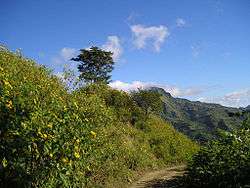
Bucari, Leon | |
 Map of Iloilo with Leon highlighted | |
.svg.png) Leon Location within the Philippines | |
| Coordinates: 10°47′N 122°23′E / 10.783°N 122.383°ECoordinates: 10°47′N 122°23′E / 10.783°N 122.383°E | |
| Country | Philippines |
| Region | Western Visayas (Region VI) |
| Province | Iloilo |
| Legislative district | 2nd district of Iloilo |
| Barangays | 85 |
| Government[1] | |
| • Mayor | Rolito C. Cajilig |
| Area[2] | |
| • Total | 140.20 km2 (54.13 sq mi) |
| Population (2010)[3] | |
| • Total | 47,522 |
| • Density | 340/km2 (880/sq mi) |
| Time zone | PST (UTC+8) |
| ZIP code | 5026 |
| Dialing code | 33 |
| Website |
www |
Leon is a second class municipality in the province of Iloilo, Philippines. Located in the southwestern part of Iloilo Province, it is 28 kilometres (17 mi) from Iloilo City. According to the 2010 census, it has a population of 47,522 people.[3]
It has a total land area of 14,020 hectares (34,600 acres) of which 276.16 hectares is classified as an urban area and 13,728.84 hectares as rural land. It is bounded by the municipalities of Alimodian in the north, San Miguel in the east, Tigbauan and Tubungan in the south, and San Remegio, Antique, in the west.
It is known as the "Vegetable Basket of Iloilo Province" due to its supply of asparagus, cabbages, baguio beans, sayote, eggplants, carrots and other vegetables.
A popular tourist attraction in the municipality is the Bucari Mountain Range, which is known as the Summer Capital of Iloilo and Vegetable Garden of Iloilo.
Barangays
Leon is politically subdivided into 85 barangays.[2]
- Agboy Norte
- Agboy Sur
- Agta
- Ambulong
- Anonang
- Apian
- Avanzada
- Awis
- Ayabang
- Ayubo
- Bacolod
- Baje
- Banagan
- Barangbang
- Barasan
- Bayag Norte
- Bayag Sur
- Binolbog
- Biri Norte
- Biri Sur
- Bobon
- Bucari
- Buenavista
- Buga
- Bulad
- Bulwang
- Cabolo-an
- Cabunga-an
- Cabutongan
- Cagay
- Camandag
- Camando
- Cananaman
- Capt. Fernando
- Carara-an
- Carolina
- Cawilihan
- Coyugan Norte
- Coyugan Sur
- Danao
- Dorog
- Dusacan
- Gines
- Gumboc
- Igcadios
- Ingay
- Isian Norte
- Isian Victoria
- Jamog Gines
- Lanag
- Lang-og
- Ligtos
- Lonoc
- Lampaya
- Magcapay
- Maliao
- Malublub
- Manampunay
- Marirong
- Mina
- Mocol
- Nagbangi
- Nalbang
- Odong-odong
- Oluangan
- Omambong
- Paoy
- Pandan
- Panginman
- Pepe
- Poblacion
- Paga
- Salngan
- Samlague
- Siol Norte
- Siol Sur
- Tacuyong Norte
- Tacuyong Sur
- Tagsing
- Talacuan
- Ticuan
- Tina-an Norte
- Tina-an Sur
- Tunguan
- Tu-og
Demographics
| Population census of Leon | ||
|---|---|---|
| Year | Pop. | ±% p.a. |
| 1990 | 36,948 | — |
| 1995 | 41,043 | +1.99% |
| 2000 | 43,729 | +1.37% |
| 2007 | 45,647 | +0.59% |
| 2010 | 47,522 | +1.48% |
| Source: National Statistics Office[3] | ||
References
- ↑ "Municipalities". Quezon City, Philippines: Department of the Interior and Local Government. Retrieved 26 February 2013.
- 1 2 "Province: Iloilo". PSGC Interactive. Makati City, Philippines: National Statistical Coordination Board. Retrieved 26 February 2013.
- 1 2 3 "Total Population by Province, City, Municipality and Barangay: as of May 1, 2010" (PDF). 2010 Census of Population and Housing. National Statistics Office. Retrieved 20 February 2013.
External links
- Municipal Government Website
- Philippine Standard Geographic Code
- Philippine Census Information
- Local Governance Performance Management System
 |
Alimodian | | ||
| San Remigio, Antique | |
Alimodian San Miguel | ||
| ||||
| | ||||
| Tubungan | Tigbauan |
Iloilo (capital) | |
| Municipalities |
|
| Component city | |
| Highly urbanized city |
|