Lake Overholser
| Lake Overholser | |
|---|---|
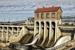 Overholser Dam in 2013 | |
| Location |
Oklahoma City, Oklahoma, United States |
| Coordinates | 35°29′52″N 97°40′47″W / 35.4977°N 97.6796°WCoordinates: 35°29′52″N 97°40′47″W / 35.4977°N 97.6796°W |
| Basin countries | United States |
| Surface area | 1,500 acres (610 ha) |
| Average depth | 6 feet |
| Max. depth | 13 feet |
| Water volume | 17,100 acre-feet |
| Shore length1 | 7 miles |
| Surface elevation | 1,242 feet |
| Settlements | Oklahoma City, Bethany |
| 1 Shore length is not a well-defined measure. | |
Lake Overholser is a reservoir within the city limits of Oklahoma City, Oklahoma. The lake straddles the line separating Oklahoma and Canadian counties. Lake Overholser is formed by Overholser Dam on the North Canadian River in Oklahoma County, Oklahoma.[lower-alpha 1] The lake is 2.9 miles (4.7 km) west of Bethany.[1] Lake Overholser is named after Ed Overholser who was the 16th Mayor of the City of Oklahoma City.[2]
The lake was originally intended to assure an adequate supply of municipal water, since the city depended primarily on the North Canadian River as a source, supplemented by private wells. The need for flood control capability became obvious when the river flooded in 1923, it breached the Lake Overholser Dam, and inundated much of the city.[3]
Description
Lake
The lake covers approximately 1,500 acres (6 km²) and was constructed in 1919 to provide water to a treatment plant. According to USGS, its capacity is 17,100 acre feet (21,100,000 m3)[4] The average depth is 6 feet (1.8 m) and the maximum depth is only 13 feet (4.0 m).[2]
U.S. Route 66, "The Mother Road", was situated along the North shore of Lake Overholser from 1926 to 1958. A 1958 Route 66 improvement project created a new alignment for the highway that relocated the roadbed about 1/4 mile North of the lake. The original 1926 section of Route 66 still exists and was renamed North Overholser Drive. It runs south of the Stonebridge Lake Estates and Ramsey Lake and is considered one of the most scenic sections of the original Route 66.
Dam
| Lake Overholser Dam | |
|---|---|
| Country | United States |
| Location | Oklahoma City, Oklahoma |
| Purpose | City water, recreation |
| Status | Complete |
| Construction began | 1917 |
| Opening date | 1918 |
| Owner(s) | City of Oklahoma City |
| Dam and spillways | |
| Type of dam | Poured concrete buttress |
| Impounds | North Canadian River (Oklahoma River) |
| Height | 68 feet |
| Length | 1650 feet |
The Lake Overholser Dam, designed by Niels Ambursen and built by the Ambursen Construction Company of New York, is 68 feet (21 m) high and 1,258 feet (383 m)long. Oklahoma City residents voted a $1.5 million bond issue in 1916 to pay for the project.[5] The dam is built of reinforced poured concrete.[6]
The dam has four distinct sections of buttressed spillways and a solid spilway. A concrete walkway extends across the dam over the buttreaaes until it comes to the larger spillway, where it is carried by a Pratt through truss.[6]
A concrete wing wall anchors the dam into the eastern river bank. The first span of the dam, between the eastern wing wall and the pump house, is wide. The brick-walled pump house has a gabled tile roof, a small chimney, and two round ventilators. It sits above four arched sluiceway openings.[6]
Recreational facilities
Lake Overholser is a popular fishing area for local residents. A covered fishing pier is on the southwest side of the lake.[2] Species of fish include: white bass, bream, bluegill, striped bass, flathead catfish, crappie, carp, catfish and largemouth bass.[1]
Boating is allowed on the lake, but swimming is prohibited.[2]
Notes
- ↑ A portion of the North Canadian River that flows through Oklahoma City was renamed the Oklahoma River in 2004.
External links
- City website, source of this information
- Hefner to Overholser Bike Trails
- Oklahoma Digital Maps: Digital Collections of Oklahoma and Indian Territory
References
- 1 2 "Lake Overholser Fishing." Accessed August 29, 2015.
- 1 2 3 4 "Adam Knapp. "Oklahoma City's Lake Overholser". Accessed August 29, 2015.
- ↑ ""Overview of Water and Related Resources Part 2." Oklahoma Water Resources Board. Accessed August 30, 2015.
- ↑ "USGS 07240500 Lake Overholser near Oklahoma City, OK." U.S. Geological Survey (USGS). August 29. 2015. Accessed August 29, 2015.
- ↑ "Lake Overholser Dam." City of Oklahoma City. Accessed August 30, 2015.
- 1 2 3 "National Register of Historic Places Registration Form: Lake Overholser Dam."