Lac-Delage, Quebec
| Lac-Delage | |
|---|---|
| City | |
 | |
 Location within La Jacques-Cartier RCM. | |
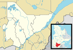 Lac-Delage Location in central Quebec. | |
| Coordinates: 46°58′N 71°24′W / 46.967°N 71.400°WCoordinates: 46°58′N 71°24′W / 46.967°N 71.400°W[1] | |
| Country |
|
| Province |
|
| Region | Capitale-Nationale |
| RCM | La Jacques-Cartier |
| Constituted | February 11, 1959 |
| Government[2] | |
| • Mayor | Marc Boiteau |
| • Federal riding | Portneuf—Jacques-Cartier |
| • Prov. riding | Chauveau |
| Area[2][3] | |
| • Total | 2.10 km2 (0.81 sq mi) |
| • Land | 1.52 km2 (0.59 sq mi) |
| Population (2011)[3] | |
| • Total | 598 |
| • Density | 393.9/km2 (1,020/sq mi) |
| • Pop 2006-2011 |
|
| • Dwellings | 243 |
| Time zone | EST (UTC−5) |
| • Summer (DST) | EDT (UTC−4) |
| Postal code(s) | G3C 5A4 |
| Area code(s) | 418 and 581 |
| Highways | No major routes |
| Website |
www |
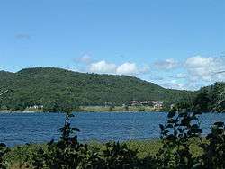
Lac-Delage is a town in the Capitale-Nationale region of Quebec, Canada, located on the eponymous Lake Delage.
Demographics
Population
| Historical Census Data - Lac-Delage, Quebec[4] | ||||||||||||||||||||||||||
|---|---|---|---|---|---|---|---|---|---|---|---|---|---|---|---|---|---|---|---|---|---|---|---|---|---|---|
|
|
| ||||||||||||||||||||||||
Private dwellings occupied by usual residents: 228 (total dwellings: 243)
Language
Mother tongue:
- English as first language: 0%
- French as first language: 100%
- English and French as first language: 0%
- Other as first language: 0%

Lake Delage
See also
References
- ↑ Reference number 33030 of the Commission de toponymie du Québec (French)
- 1 2 Ministère des Affaires municipales, des Régions et de l'Occupation du territoire - Répertoire des municipalités: Lac-Delage
- 1 2 Statistics Canada 2011 Census - Lac-Delage census profile
- ↑ Statistics Canada: 1996, 2001, 2006, 2011 census
 |
Stoneham-et-Tewkesbury | | ||
| Quebec City | |
Stoneham-et-Tewkesbury | ||
| ||||
| | ||||
| Quebec City |
| Cities & towns | |
|---|---|
| Municipalities | |
| United Townships | |
| Unorganized territories | |
| |
This article is issued from Wikipedia - version of the 3/2/2014. The text is available under the Creative Commons Attribution/Share Alike but additional terms may apply for the media files.