Koudekerke
| Koudekerke | ||
|---|---|---|
| Town | ||
|
Koudekerke Protestant church: Michaëlskerk | ||
| ||
 | ||
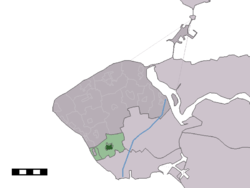 The town centre (dark green) and the statistical district (light green) of Koudekerke in the municipality of Veere. | ||
| Coordinates: 51°29′51″N 3°33′10″E / 51.49750°N 3.55278°ECoordinates: 51°29′51″N 3°33′10″E / 51.49750°N 3.55278°E | ||
| Country | Netherlands | |
| Province | Zeeland | |
| Municipality | Veere | |
| Population (1 January 2010) | ||
| • Total | 3,495 | |
| Time zone | CET (UTC+1) | |
| • Summer (DST) | CEST (UTC+2) | |


Koudekerke is a town in the Dutch province of Zeeland. It is a part of the municipality of Veere, and lies about 3 km northwest of Vlissingen.
In 2001, the town of Koudekerke had 2687 inhabitants. The built-up area of the town was 0.55 km², and contained 1133 residences.[1] The statistical area "Koudekerke", which also can include the surrounding countryside, has a population of around 3300.[2]
Koudekerke was formerly a junction on Stoomtram Walcheren between the main line (Vlissingen to Domburg) and the branch to Middelburg. The depot and works were in the town; the station building and workers' houses survive.
Gallery
-

Windmill "De Lelie" at dusk
-
Het Hof Van Krien Van Floor
-

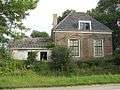
Huis Moesbosch
-

Bunker in Koudedkerke

See also
References
- ↑ Statistics Netherlands (CBS), Bevolkingskernen in Nederland 2001 . (Statistics are for the continuous built-up area).
- ↑ Statistics Netherlands (CBS), Statline: Kerncijfers wijken en buurten 2003-2005 "Archived copy". Archived from the original on July 24, 2006. Retrieved July 24, 2006.. As of 1 January 2005.
External links
![]() Media related to Koudekerke at Wikimedia Commons
Media related to Koudekerke at Wikimedia Commons