Veere
| Veere | |||
|---|---|---|---|
| Municipality and city | |||
|
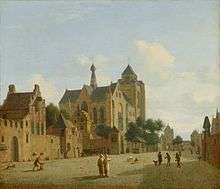
The city of Veere in 2007 | |||
| |||
.svg.png) Location in Zeeland | |||
| Coordinates: 51°34′N 3°30′E / 51.567°N 3.500°ECoordinates: 51°34′N 3°30′E / 51.567°N 3.500°E | |||
| Country | Netherlands | ||
| Province | Zeeland | ||
| Government[1] | |||
| • Body | Municipal council | ||
| • Mayor | Rob van der Zwaag (CDA) | ||
| Area[2] | |||
| • Total | 206.63 km2 (79.78 sq mi) | ||
| • Land | 133.13 km2 (51.40 sq mi) | ||
| • Water | 73.50 km2 (28.38 sq mi) | ||
| Elevation[3] | 0 m (0 ft) | ||
| Population (May 2014)[4] | |||
| • Total | 21,953 | ||
| • Density | 165/km2 (430/sq mi) | ||
| Time zone | CET (UTC+1) | ||
| • Summer (DST) | CEST (UTC+2) | ||
| Postcode | 4350–4379 | ||
| Area code | 0118 | ||
| Website |
www | ||


Veere (Dutch pronunciation: [ˈveːrə]; Zeelandic: Ter Veere) is a municipality with a population of 22,000 and a city with a population of 1,500 in the southwestern Netherlands, on Walcheren island in the province of Zeeland.
History
The name Veere means "ferry": Wolfert Van Borsselen established a ferry there in 1281.[5] Veere received city rights in 1355.
The "Admiraliteit van Veere" (Admiralty of Veere) was set up as a result of the Ordinance on the Admiralty of 8 January 1488 in an attempt to create a central naval administration in the Burgundian Netherlands. To this was subordinated the Vice-Admiralty of Flanders in Dunkirk. In 1560 under admiral Philip de Montmorency, Count of Hoorn, this admiralty relocated near Ghent and in 1561 the Habsburg naval forces were also moved to Veere.
Veere functioned as the staple port for Scotland[6] between 1541 and 1799.
Flemish architects Antonis Keldermans and Evert Spoorwater designed the Grote Kerk, the fortifications, the Cisterne and the town hall. During this period of prosperity, the cultural centre was located at Sandenburgh castle, the residence of the noble Van Borsele and Van Bourgondië families. Court painter Jan Gossaert van Mabuse worked here.[7] The poet Adrianus Valerius lived and worked in the city from 1591. In the 17th and 18th centuries, Veere was a prosperous trading city, with about 750 houses inside the city walls then, compared to about 300 as of 2013.
At the start of the Second World War, there was a Royal Netherlands Navy seaplane base at Veere, with six Fokker C XIV-W aircraft. On 12 May 1940 the base was bombed by He-111 bombers causing some casualties.[8] On 14 May, the seaplanes were ordered to evacuate to France and then England, eventually arriving in the Dutch East Indies where they would be destroyed in action with the Japanese in 1941 and 1942.[9] On 17 May, German infantry of SS Regiment Deutschland of the 2nd SS Panzer Division crossed onto Walcheren via the Sloedam and by 18:00 that evening, the Dutch forces on the island, including the garrison at Veere, were ordered to surrender.[10] Veere was finally liberated on 7 November 1944 by Scottish troops of the British 52nd (Lowland) Infantry Division during Operation Infatuate, the Allied assault on Walcheren. As part of the preparations for the operation, the island's sea dykes were bombed resulting in the inundation of much of the area. Unlike many other towns on the island, Veere was virtually undamaged in the fighting.[11]
As a result of the damming of the Veerse Gat inlet in 1961, the fishing fleet of Veere moved to a new home port at Colijnsplaat on Noord-Beveland.[12] As of 2013 the main business of the town is tourism.
Veere municipality reached its current expanded shape in 1997, after the addition of several neighboring towns. During the course of nearly two centuries seventeen historical municipalities have merged to become present-day Veere. Its original full name was 'Veere-de-Stad en Zanddijk-Binnen'.
Geography

The city of Veere stands on the Veerse Meer lagoon on the island of Walcheren in the province of Zeeland in the Netherlands.
The area of the municipality of Veere is 13,496 hectares, with a coastline of 34 kilometres and a population of about 22,000. The population centres in the municipality are:
- Aagtekerke (population as of 2003: 1,479)
- Biggekerke (895)
- Domburg (1,481)
- Gapinge (522)
- Grijpskerke (1,377)
- Joossesweg (20)
- Koudekerke (3,620)
- Meliskerke (1,477)
- Oostkapelle (2,451)
- Serooskerke (1,833)
- Veere (1,520)
- Vrouwenpolder (1,125)
- Westkapelle (2,672)
- Zoutelande (1,593)
Tourism
The area is visited by 4 million tourists annually. The main attractions are the beaches and marinas. The Storm Surge Barrier on the Oosterschelde is the most popular visitor attraction in Zeeland.[13] The Scoutcentrum Zeeland on the coast of the Veerse Meer attracts Scout visitors from around the world[14]
In fiction
The town of Veere forms the setting for "Van Loon's Lives", a book of contemporary fantasy written by Hendrik Willem Van Loon in 1942, in which the protagonists are able to magically summon the great men and women of history for weekend dinner parties, leading to often humorous incidents. The book was written at the time when Veere, like the rest of the Netherlands, lay under Nazi occupation, and despite its light-hearted tone clearly indicates the longing of the writer - living in the US - for his homeland whose liberation he was doomed never to see.
Gallery
 Harbour of Veere
 Windmill: The "de Koe" corn windmill
 Koudekerk, church: Michaëlskerk
 Westkapelle, light house
 Gapinge, church
 Domburg, castle/youth hostel
 Serooskerke, windmill
 Zoutelande, church
References
- ↑ "Burgemeester" [Mayor] (in Dutch). Gemeente Veere. Retrieved 18 December 2013.
- ↑ "Kerncijfers wijken en buurten" [Key figures for neighbourhoods]. CBS Statline (in Dutch). CBS. 2 July 2013. Retrieved 12 March 2014.
- ↑ "Postcodetool for 4357ET". Actueel Hoogtebestand Nederland (in Dutch). Het Waterschapshuis. Retrieved 18 December 2013.
- ↑ "Bevolkingsontwikkeling; regio per maand" [Population growth; regions per month]. CBS Statline (in Dutch). CBS. 26 June 2014. Retrieved 24 July 2014.
- ↑ http://www.veerhuis.org/genealogy/NethBook/NetherlandsBook.html
- ↑ AT HOME ABROAD: ETHNICITY AND ENCLAVE IN THE WORLD OF SCOTS TRADERS IN NORTHERN EUROPE, c. 1600-1800* by DOUGLAS CATTERALL (page 4)
- ↑ http://www.veere.nl/index.php?simaction=content&mediumid=1&pagid=258&stukid=534
- ↑ "War over Holland - Zeeland - The airforce and navy air fleet bases". www.waroverholland.nl. Retrieved 13 April 2015.
- ↑ "War over Holland - Zeeland - The AFB's". www.waroverholland.nl. Retrieved 13 April 2015.
- ↑ "War over Holland - Zeeland - Capitulation of Walcheren and Zuid-Beveland". www.waroverholland.nl. Retrieved 13 April 2015.
- ↑ "NL06 - Operation Infatuate". www.scottishdiasporatapestry.org. Retrieved 13 April 2015.
- ↑ http://islas.ruudbijlsma.nl/wcr_en.htm
- ↑ http://www.veere.nl/index.php?simaction=content&mediumid=1&pagid=258&stukid=533
- ↑ http://scoutcentrumzeeland.scouting.nl/index.php/welcome
External links
| Wikimedia Commons has media related to Veere. |
- Official website
- Veere in the picture, Beautiful photos of Veere.
- Website about the historic city of Veere
 |
Veerse Meer / Noord-Beveland | | ||
| North Sea | |
Middelburg | ||
| ||||
| | ||||
| Vlissingen |
Municipalities of Zeeland | ||
|---|---|---|
 | ||
| ||