Kopachi
| Kopachi Копачі | |
|---|---|
| Village | |
|
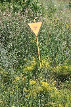
The site of one of the buried houses of Kopachi | |
 Kopachi Location of Kopachi in Ukraine | |
| Coordinates: 51°21′3.6″N 30°7′55.2″E / 51.351000°N 30.132000°ECoordinates: 51°21′3.6″N 30°7′55.2″E / 51.351000°N 30.132000°E | |
| Country |
|
| Oblast |
|
| Raion |
Chernobyl (1923–1988) Ivankiv (since 1988) |
| Elevation | 123 m (404 ft) |
| Population (1986) | |
| • Total | 0 |
| Area code(s) | +380 4493 |
Kopachi (Ukrainian: Копачі, Russian: Копачи) was a village near Chernobyl, Ukraine, just south-west of the Pripyat River Basin. After the Chernobyl disaster in 1986 the village was contaminated by fallout and subsequently evacuated and is now within the Chernobyl Exclusion Zone; and thus has been abandoned since 1986.
History
After Kopachi village was evacuated by the authorities, all the houses were torn down and buried, as an experiment. This village was the only village suffering this fate as a result of the Chernobyl disaster.[1]
The only traces left of the village today is a series of mounds and a small number of surviving trees which are not part of the local native flora. Each mound contains the remains of one house and is topped by a sign with the international radiation symbol.[2] The Chernobyl disaster highly contaminated Kopachi with high-level radioactive fallout.[3] A kindergarten and one other brick building are the only architectural structures that remain standing, all other buildings were bulldozed. The government did not recognize the fact that these highly-contaminated buildings and houses would seep radioactive isotopes into the water table. Burying the buildings drove radio-toxins deeper into the environment. The soil and water surrounding the former village remain contaminated with radioactive materials including plutonium, strontium-90, and caesium-137. Other villages in the exclusion zone faced a similar fate, thus polluting the aquifer. [4][5]
Geography
The village, located few km south of the Chernobyl Plant and close to its cooling pond, lies on the road between Pripyat and Chernobyl. Other near settlements are the villages of Leliv and Yaniv.[6]
Gallery
|

.jpg)
See also
References
- ↑ "Chernobyl 25 years on: a poisoned landscape", Robin McKie, The Guardian, accessed 2011-03-27
- ↑ Fincher, Lindsay. "Dispatches from Chernobyl, Part II: Liquidators Memorial / Kopachi / Catfish / Reactor 4". At Home in the Wasteland.
- ↑ Burlakova, E.B.; Naidich, Valeria I. (2006). 20 Years After the Chernobyl Accident: Past, Present and Future. NOVA Science Publishing Inc. pp. 299 – 301. ISBN 978-1600212499. Retrieved 6 February 2015.
- ↑ Resnicoff, Mark. "Kopachi Village". Chernobyl and Eastern Europe. Retrieved 5 February 2015.
- ↑ "Kopachi Village". Pripyat.com.
- ↑ 278461985 Kopachi on OpenStreetMap
External links
![]() Media related to Kopachi at Wikimedia Commons
Media related to Kopachi at Wikimedia Commons