Kolmanskop
Kolmanskop (Afrikaans for Coleman's hill, German: Kolmannskuppe) is a ghost town in the Namib desert in southern Namibia, 10 kilometres inland from the port town of Lüderitz. It was named after a transport driver named Johnny Coleman who, during a sand storm, abandoned his ox wagon on a small incline opposite the settlement.[1] Once a small but very rich mining village, it is now a popular tourist destination run by the joint firm NamDeb (Namibia-De Beers).
In 1908 the worker Zacharias Lewala found a diamond while working in this area and showed it to his supervisor, the German railway inspector August Stauch. Realizing the area was rich in diamonds, German miners began settlement, and soon after the German government declared a large area as a "Sperrgebiet", starting to exploit the diamond field.[2]
Driven by the enormous wealth of the first diamond miners, the residents built the village in the architectural style of a German town, with amenities and institutions including a hospital, ballroom, power station, school, skittle-alley, theatre and sport-hall, casino, ice factory and the first x-ray-station in the southern hemisphere, as well as the first tram in Africa. It had a railway link to Lüderitz.
The town declined after World War I when the diamond-field slowly exhausted and was ultimately abandoned in 1954. The geological forces of the desert mean that tourists now walk through houses knee-deep in sand. Kolmanskop is popular with photographers for its settings of the desert sands' reclaiming this once-thriving town. Due to its location within the restricted area (Sperrgebiet) of the Namib desert, tourists need a permit to enter the town. Permits can be bought at the gate into the town and tours run daily at 9:30am and 11am local time(GMT+2), 10am on a Sunday.
In popular culture
- Kolmanskop was used as the location for the South African TV series The Mantis Project (1985). Directed by Manie van Rensburg, produced by Paul Kemp, written by John Cundill, and starred Marius Weyers and Sandra Prinsloo.
- The town was used as one of the locations in the 1993 film Dust Devil.
- The 2000 film The King Is Alive was filmed in Kolmanskop, with the town used as the film's main setting.[3]
- The town was featured in a 2010 episode of Life After People. The episode focused on the effects of wind and sand upon the various run-down buildings and displayed rooms that were filled with sand.
- The town was used as one of the locations in the 1994 film Lunarcop.
- The town was used in the first episode of the BBC series Wonders of the Universe to help explain entropy and its effect on time.
- The television series Destination Truth in one of its episodes investigated Kolmanskop, rumored to be haunted.
- Tim Walker photographed Agyness Deyn in Kolmanskop, Namibia for Vogue UK in May 2011.
- The 2011 non-narrative film Samsara features shots filmed in Kolmanskop.[4]
- Featured in 2011 on Season 1, Episode 2 Namibia/Bodie of the television show "Forgotten Planet"
Literature
- Noli, Gino: Desert Diamonds. Gino Noli, Plettenberg Bay 2010, ISBN 978-0-620-40680-2.
Gallery
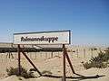 The town sign of Kolmannskuppe
 Abandoned houses in Kolmanskop
 Abandoned houses.
 After the depopulation, sand invaded the houses.
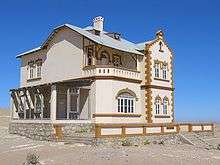 House of the former mine manager
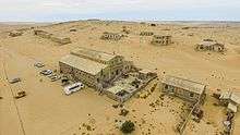
.jpg) Main view of Kolmannskuppe.
Main view of Kolmannskuppe.
See also
| Wikimedia Commons has media related to Kolmanskop. |
References
- ↑ "Kolmanskop". Namibia Travel Companion 2013. Namibia Travel Companion. Retrieved 11 November 2013.
- ↑ Schneider, G. (2008). Treasures of the Diamond Coast. Windhoek: MacMillan Education. ISBN 978-99916-0-968-3.
- ↑ The King Is Alive, IMDB
- ↑ SAMSARA LOCATION LIST, Cincinnati World Cinema
External links
- "Kolmanskop Ghost Town Tour". The Cardboard Box Travel Shop (website). Retrieved 11 November 2013.
- Martin, Grant (3 Sep 2013). "New Photos from Kolmanskop, Namibia's Abandoned Diamond Ghost Town". Forbes. Retrieved 11 November 2013.
- "A Ghost Town Devoured by the Namibian Desert". Environmental Graffiti (2010). Retrieved 11 November 2013.
Coordinates: 26°42′15″S 15°13′57″E / 26.70406°S 15.232365°E