Kollayil (village)
| Kollayil | |
|---|---|
| village | |
 Kollayil  Kollayil Location in Kerala, India | |
| Coordinates: 8°23′21″N 77°08′05″E / 8.3892°N 77.1348°ECoordinates: 8°23′21″N 77°08′05″E / 8.3892°N 77.1348°E | |
| Country |
|
| State | Kerala |
| District | Thiruvananthapuram |
| Talukas | Neyyattinkara |
| Government | |
| • Body | Gram panchayat |
| Population (2001) | |
| • Total | 25,148 |
| Languages | |
| • Official | Malayalam, English |
| Time zone | IST (UTC+5:30) |
| PIN | 6XXXXX |
| Vehicle registration | KL- |
Kollayil is a village in Thiruvananthapuram district in the state of Kerala, India.Kollayil Post Office PIN code is 691541, There are 3 schools in Kollayil area.
Schools in Kollayil
- Kollayil LPS - This is an Upper Primary School established in 1962. This school situates at Kollayil near the Thiruvananthapuram-Schencotta road. There are about 700 students and 22 teachers at this school.
- Jawahar LPS Kurakkodu - This is a Lower Primary School established in 1976.
- Sree Narayana Upper Primary School KOLLAYIL
Demographics
As of 2001 India census, Kollayil had a population of 25148 with 12324 males and 12824 females.[1]
District HQ: Thiruvananthapuram | |||||||||||
| History | 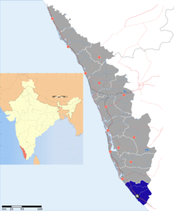 | ||||||||||
| Geography | |||||||||||
| Cities and Taluks |
| ||||||||||
| Transport | |||||||||||
| Education |
| ||||||||||
| Buildings | |||||||||||
| Culture | |||||||||||
| Lok Sabha constituencies | |||||||||||
| Sports | |||||||||||
| Museums | |||||||||||
References
- 1 2 "Census of India : Villages with population 5000 & above". Archived from the original on December 8, 2008. Retrieved 2008-12-10.
|first1=missing|last1=in Authors list (help) - ↑ "Yahoo Maps India : Kollayil". Retrieved 2008-12-18.
This article is issued from Wikipedia - version of the 10/20/2016. The text is available under the Creative Commons Attribution/Share Alike but additional terms may apply for the media files.