Nedumangad (tehsil)
| Nedumangad taluk | |
|---|---|
| taluk | |
 Nedumangad taluk  Nedumangad taluk Location in Kerala, India | |
| Coordinates: 8°36′12″N 77°00′10″E / 8.60333°N 77.00278°ECoordinates: 8°36′12″N 77°00′10″E / 8.60333°N 77.00278°E | |
| Country |
|
| State | Kerala |
| District | Thiruvananthapuram |
| Headquarters | Nedumangad |
| Languages | |
| • Official | Malayalam, English |
| Time zone | IST (UTC+5:30) |
| Vehicle registration | KL-21 |
Nedumangad Taluk is a Taluk (tehsil) in Thiruvananthapuram district in the Indian state of Kerala.[1] It situated in the eastern part of the Thiruvananthapuram district. It comprises 28 villages and one municipality.
It is bounded on the west by Trivandrum Taluk, on the east by the State of Tamil Nadu, on the south by Neyyattinkara Taluk and on the north by Kollam District.
Settlements
There are 28 villages and one Municipality in this taluk.[2]
Villages
Anad, Aruvikkara, Aryanad, Kallara, Karakulam, Koliyakode, Kurupuzha, Manikkal, Mannoorkara, Nedumangad, Nellanad, Palode, Panavoor, Pangode, Peringamala, Perumkulam, Pullampara, Theakada, Thennoor, Tholicode, Uzhamalackal, Vamanapuram, Vattappara, Veeranakavu, Vellanad, Vembayam, Vithura.
Municipalities
There is only one municipality, Nedumangad, which is also the headquarters of the taluk.
References
- ↑ Nedumangad taluk
- ↑ "Nedumangad Taluk". About nedumangad. National Informatics Centre Thiruvananthapuram. Retrieved 26 June 2010.
District HQ: Thiruvananthapuram | |||||||||||
| History | 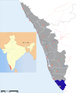 | ||||||||||
| Geography | |||||||||||
| Cities and Taluks |
| ||||||||||
| Transport | |||||||||||
| Education |
| ||||||||||
| Buildings | |||||||||||
| Culture | |||||||||||
| Lok Sabha constituencies | |||||||||||
| Sports | |||||||||||
| Museums | |||||||||||