Klondike, Oregon
| Klondike, Oregon | |
|---|---|
| Unincorporated community | |
 Klondike, Oregon  Klondike, Oregon | |
| Coordinates: 45°34′59″N 120°36′50″W / 45.583°N 120.614°WCoordinates: 45°34′59″N 120°36′50″W / 45.583°N 120.614°W | |
| Country | United States |
| State | Oregon |
| County | Sherman |
| Elevation | 1,558 ft (475 m) |
| Time zone | Pacific (PST) (UTC-8) |
| • Summer (DST) | PDT (UTC-7) |
| ZIP code | 97065 |
| Area code(s) | 458 and 541 |
Klondike is an unincorporated community in Sherman County, Oregon, United States.[1] It is near the Wasco, Oregon site of the Klondike III Wind Project, Oregon's largest wind energy farm with 176 turbines for wind energy.[2]
A.B. Potter was first postmaster of its post office, which was established on January 11, 1899. The office closed on November 30, 1951.[3]
References
- ↑ "Klondike". Geographic Names Information System. United States Geological Survey. November 28, 1980. Retrieved December 24, 2010.
- ↑ "Energy facility siting: Klondike III Wind Project". Oregon.Gov. Retrieved December 24, 2010.
- ↑ McArthur, Lewis A.; McArthur, Lewis L. (2003) [1928]. Oregon Geographic Names (7th ed.). Portland, Oregon: Oregon Historical Society Press. ISBN 978-0875952772.
Municipalities and communities of Sherman County, Oregon, United States | ||
|---|---|---|
| Cities | 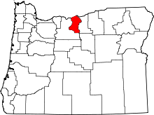 | |
| CDP | ||
| Other communities | ||
This article is issued from Wikipedia - version of the 7/31/2016. The text is available under the Creative Commons Attribution/Share Alike but additional terms may apply for the media files.