Kiryat Ata
Kiryat Ata
| ||
|---|---|---|
| Hebrew transcription(s) | ||
| • ISO 259 | Qiryat ʔataˀ | |
| • Also spelled |
Qiryat Ata (official) Kiryat Ata (unofficial) | |
 | ||
| ||
 Kiryat Ata | ||
| Coordinates: 32°48′N 35°06′E / 32.800°N 35.100°ECoordinates: 32°48′N 35°06′E / 32.800°N 35.100°E | ||
| Grid position | 160/244 PAL | |
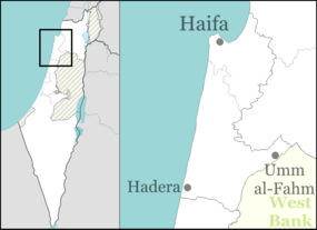
| District | Haifa | |
| Government | ||
| • Type | City (from 1969) | |
| • Mayor | Yaakov Peretz | |
| Area | ||
| • Total | 16,706 dunams (16.706 km2 or 6.450 sq mi) | |
| Population (2015)[1] | ||
| • Total | 55,464 | |

Kiryat Ata (Hebrew: קִרְיַת אָתָא; also Qiryat Ata, Arabic: كريات آتا, Kiryāt ʾĀtā) is a city in the Haifa District of Israel. Also still known by its former name of Kfar Ata (Hebrew: כְּפַר עָטָּה), in 2015 it had a population of 55,464.
History
Archeological surveys at Khirbet Sharta in the northeast part of the city revealed traces of habitation dating to the Bronze, Iron, Hellenistic, Roman, Byzantine, and Mamluk eras.
In 1283 it was mentioned as part of the domain of the Crusaders, according to the hudna between the Crusaders and the Mamluk sultan Qalawun. At the time it was called Kafrata.[2]
Ottoman era
Incorporated into the Ottoman Empire in 1517, Kufrata appeared in the census of 1596, located in the Nahiya of Acca of the Liwa of Safad. The population was 15 households, all Muslim. They paid taxes on wheat, barley, fruit trees, cotton, occasional revenues, goats and beehives; a total of 1508 Akçe.[3][4] The village appeared under the name of Koufour Tai on the map that Pierre Jacotin compiled during Napoleon's invasion of 1799.[5]
In 1859 the population was estimated to be 100, and the cultivation was 16 feddans.[6] In 1875 Victor Guérin visited, and found the village to have 50 houses.[7] In 1881 the Palestine Exploration Fund's Survey of Western Palestine described Kefr Etta[8] as "a small adobe village, on the plain, with a well on the north and olives on the east."[6]
British Mandate era
In the 1922 census of Palestine conducted by the British Mandate authorities, Kufritta showed a population of 400; 7 Christians and 393 Muslims,[9] where all the Christians were of the Orthodox faith.[10]
In 1925 a Zionist organisation purchased 10,000 dunums in Kefr Etta from Alexander Sursock, of the Sursock family of Beirut. At the time, there were 75 families living there.[11]
In the 1931 census Kufritta had a population of 4 Muslims and 29 Jews, in a total of 13 occupied houses.[12]
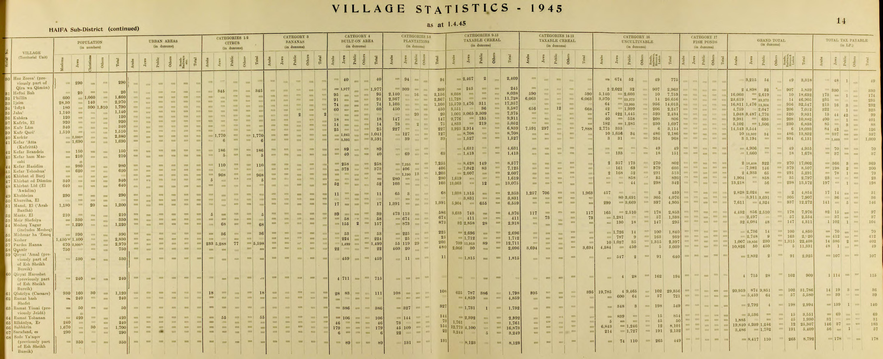
In 1945 the population of Kefar Atta (Kufritta) consisted of 1,690 Jews and the land area was 6,131 dunams, according to an official land and population survey.[13][14] Of this, 6 dunams were designated for citrus and bananas, 39 dunams for plantations and irrigable land, 1,527 for cereals,[15] while 3,591 dunams were built-up areas.[16]
Kiryat Ata

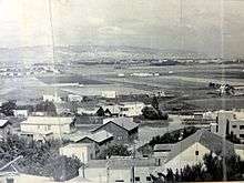
In the early 20th century, the lands of the Arab village of Kefr Etta were purchased by a Warsaw religious foundation named "Avodat Israel" through intermediaries in the American Zion Commonwealth. Avodat Israel founded Kfar Ata in 1925. During the 1929 Arab riots the town was attacked and abandoned. A year later the residents returned and rebuilt the community. It was renamed Kiryat Ata in 1965 when the village was merged with adjacent Kiryat Binyamin.
Climate
Kiryat Ata has a Mediterranean climate with hot, dry summers and cool and rainy winters. The hottest month is July and the coldest is February. Snowfall is rare, but snow was recorded three times in the 20th century: in 1950, 1992 and 1999. Annual precipitation is approximately 524 millimeters (21 in).
Demographics
According to CBS, in 2001 the ethnic makeup of the city was 99.8% Jewish and other non-Arab, without significant Arab population. See Population groups in Israel. According to CBS, in 2001 there were 23,700 males and 24,900 females. The population of the city was spread out with 31.4% 19 years of age or younger, 15.7% between 20 and 29, 18.5% between 30 and 44, 18.3% from 45 to 59, 4.1% from 60 to 64, and 11.9% 65 years of age or older. The population growth rate in 2001 was 0.8%.
Income
In 2000, there were 17,236 salaried workers and 1,226 self-employed. The mean monthly wage was ILS 5,157. Salaried males had a mean monthly wage of ILS 6,759 (a real change of 4.6%) versus ILS 3,456 for females (a real change of 2.7%). The mean income for the self-employed was 6,470. There were 1,092 people who received unemployment benefits and 4,153 people who received an income guarantee.

Education

In 2000, there were 20 schools and 8,762 students in the city: 14 elementary schools with 4,899 students, and 11 high schools with 3,863 students. 52.0% of 12th graders were entitled to a matriculation certificate in 2001.
Sports
The city's main football club, Maccabi Ironi Kiryat Ata, plays in Liga Leumit, the second tier of Israeli football. The local basketball club, Elitzur Kiryat Ata, are in Ligat HaAl, the top division.
Notable persons
- Erich Moller (1895-1996), Industrialist, founder of ATA textile industries
- Tal Friedman (born 1963), comedian, actor and musician
- Yaniv Katan, association football player
- Alon Abutbul, Israeli actor
- Hovi Star, Israeli singer
- Yuval Noah Harari, an Israeli author and historian, was born in Kiryat Ata
References
- ↑ "List of localities, in Alphabetical order" (PDF). Israel Central Bureau of Statistics. Retrieved 16 October 2016.
- ↑ al-Qalqashandi version of the hudna, referred in Barag, 1979, p. 207, no. 59
- ↑ Hütteroth and Abdulfattah, 1977, p. 193
- ↑ Note that Rhode, 1979, p. 6 writes that the Safad register that Hütteroth and Abdulfattah studied was not from 1595/6, but from 1548/9
- ↑ Karmon, 1960, p. 162
- 1 2 Conder and Kitchener, 1881, SWP I, p. 285
- ↑ Guérin, 1880, p. 409
- ↑ meaning "Village of Etta", where Etta is a personal name, according to Palmer, 1881, p. 110
- ↑ Barron, 1923, Table XI, Sub-district of Haifa, p. 33
- ↑ Barron, 1923, Table XVI, p. 49
- ↑ List of villages sold by Sursocks and their partners to the Zionists since British occupation of Palestine, evidence to the Shaw Commission, 1930
- ↑ Mills, 1932, p. 94
- ↑ Department of Statistics, 1945, p. 14
- ↑ Government of Palestine, Department of Statistics. Village Statistics, April, 1945. Quoted in Hadawi, 1970, p. 48
- ↑ Government of Palestine, Department of Statistics. Village Statistics, April, 1945. Quoted in Hadawi, 1970, p. 90
- ↑ Government of Palestine, Department of Statistics. Village Statistics, April, 1945. Quoted in Hadawi, 1970, p. 140
Bibliography
| Wikimedia Commons has media related to Kiryat Ata. |
- Barag, Dan (1979). "A new source concerning the ultimate borders of the Latin Kingdom of Jerusalem". Israel Exploration Journal. 29: 197–217.
- Barron, J. B., ed. (1923). Palestine: Report and General Abstracts of the Census of 1922. Government of Palestine.
- Conder, Claude Reignier; Kitchener, H. H. (1881). The Survey of Western Palestine: Memoirs of the Topography, Orography, Hydrography, and Archaeology. 1. London: Committee of the Palestine Exploration Fund.
- Department of Statistics (1945). Village Statistics, April, 1945. Government of Palestine.
- Guérin, Victor (1880). Description Géographique Historique et Archéologique de la Palestine (in French). 3: Galilee, pt. 1. Paris: L'Imprimerie Nationale.
- Hadawi, Sami (1970). Village Statistics of 1945: A Classification of Land and Area ownership in Palestine. Palestine Liberation Organization Research Center.
- Hütteroth, Wolf-Dieter; Abdulfattah, Kamal (1977). Historical Geography of Palestine, Transjordan and Southern Syria in the Late 16th Century. Erlanger Geographische Arbeiten, Sonderband 5. Erlangen, Germany: Vorstand der Fränkischen Geographischen Gesellschaft. ISBN 3-920405-41-2.
- Karmon, Y. (1960). "An Analysis of Jacotin's Map of Palestine" (PDF). Israel Exploration Journal. 10 (3,4): 155–173; 244–253.
- Mills, E., ed. (1932). Census of Palestine 1931. Population of Villages, Towns and Administrative Areas. Jerusalem: Government of Palestine.
- Palmer, E. H. (1881). The Survey of Western Palestine: Arabic and English Name Lists Collected During the Survey by Lieutenants Conder and Kitchener, R. E. Transliterated and Explained by E.H. Palmer. Committee of the Palestine Exploration Fund.
- Rhode, Harold (1979). Administration and Population of the Sancak of Safed in the Sixteenth Century. Columbia University.
External links
- CBS population estimates for 2005/2006
- (Hebrew) Municipality website
- (Hebrew) Beit Fischer City Museum
- Survey of Western Palestine, Map 5: IAA, Wikimedia commons