Kino Springs, Arizona
| Kino Springs, Arizona | |
|---|---|
| Census-designated place | |
 Kino Springs, Arizona | |
| Coordinates: 31°21′48″N 110°48′36″W / 31.36333°N 110.81000°WCoordinates: 31°21′48″N 110°48′36″W / 31.36333°N 110.81000°W | |
| Country | United States |
| State | Arizona |
| County | Santa Cruz |
| Area | |
| • Total | 0.3 sq mi (0.7 km2) |
| • Land | 0.3 sq mi (0.7 km2) |
| • Water | 0 sq mi (0 km2) |
| Elevation | 4,000 ft (1,000 m) |
| Population (2010) | |
| • Total | 136 |
| • Density | 500/sq mi (190/km2) |
| Time zone | MST (no daylight saving time) (UTC-7) |
| Area code(s) | 520 |
| FIPS code | 04-37935 |
| GNIS feature ID | 0036683 |
Kino Springs is a census-designated place (CDP) in Santa Cruz County, Arizona, United States. The population was 136 at the 2010 census.[1]
Geography
Kino Springs is located at 31°21′48″N 110°48′36″W / 31.36333°N 110.81000°W,[2] 5 miles (8 km) east of Beyerville and 9 miles (14 km) east of Nogales. Kino Springs Country Club, with a par-72 golf course, is located along Kino Springs Drive halfway between Beyerville and Kino Springs.
According to the United States Census Bureau, the CDP has a total area of 0.27 square miles (0.7 km2), all of it land.[1]
References
- 1 2 "Geographic Identifiers: 2010 Demographic Profile Data (G001): Kino Springs CDP, Arizona". U.S. Census Bureau, American Factfinder. Retrieved December 4, 2012.
- ↑ "US Gazetteer files: 2010, 2000, and 1990". United States Census Bureau. 2011-02-12. Retrieved 2011-04-23.
Municipalities and communities of Santa Cruz County, Arizona, United States | ||
|---|---|---|
| City | 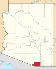 | |
| Town | ||
| CDPs | ||
| Unincorporated communities | ||
| Ghost towns | ||
This article is issued from Wikipedia - version of the 7/29/2014. The text is available under the Creative Commons Attribution/Share Alike but additional terms may apply for the media files.