Kern Valley Airport
| Kern Valley Airport | |||||||||||
|---|---|---|---|---|---|---|---|---|---|---|---|
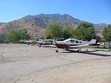 Mt SAC Flying Team annual practice at L05 | |||||||||||
| IATA: none – ICAO: none – FAA LID: L05 | |||||||||||
| Summary | |||||||||||
| Airport type | Public | ||||||||||
| Operator | County of Kern | ||||||||||
| Location | Kernville, California | ||||||||||
| Elevation AMSL | 2,614 ft / 796.7 m | ||||||||||
| Coordinates | 35°43′42″N 118°25′11″W / 35.72833°N 118.41972°WCoordinates: 35°43′42″N 118°25′11″W / 35.72833°N 118.41972°W | ||||||||||
| Runways | |||||||||||
| |||||||||||
Kern Valley Airport (FAA LID: L05) is a public airport located in the Kern River Valley, 3 miles (4.8 km) south of Kernville in Kern County, California. It serves the Lake Isabella area in the Southern Sierra Nevada.
The airport is mostly used for general aviation.
Facilities
Kern Valley Airport covers 270 acres (109 ha) and has one runway:
- Runway 17/35: 3,500 x 50 ft. (1,067 x 15 m), Surface: Asphalt
Use
Average of 28 operations per day.
| Commercial | Air Taxi | GA Local | GA Transient | Military |
|---|---|---|---|---|
| 0 | 0 | 14 | 14 | 0 |
20 aircraft based at airport
| Single Engine | Multi Engine | Jet | Helicopter | Glider/ Ultralight | Military |
|---|---|---|---|---|---|
| 20 | 0 | 0 | 0 | 0 | 0 |
See also
References
External links
- Resources for this airport:
- FAA airport information for L05
- AirNav airport information for L05
- FlightAware airport information and live flight tracker
- SkyVector aeronautical chart for L05
This article is issued from Wikipedia - version of the 9/23/2015. The text is available under the Creative Commons Attribution/Share Alike but additional terms may apply for the media files.