Kasota, Minnesota
| Kasota, Minnesota | |
|---|---|
| City | |
 Location of Kasota, Minnesota | |
| Coordinates: 44°17′26″N 93°57′51″W / 44.29056°N 93.96417°W | |
| Country | United States |
| State | Minnesota |
| County | Le Sueur |
| Government | |
| • Type | Mayor - Council |
| • Mayor | Bridget Klein |
| Area[1] | |
| • Total | 1.00 sq mi (2.59 km2) |
| • Land | 1.00 sq mi (2.59 km2) |
| • Water | 0 sq mi (0 km2) |
| Elevation | 807 ft (246 m) |
| Population (2010)[2] | |
| • Total | 675 |
| • Estimate (2012[3]) | 669 |
| • Density | 675.0/sq mi (260.6/km2) |
| Time zone | Central (CST) (UTC-6) |
| • Summer (DST) | CDT (UTC-5) |
| ZIP code | 56050 |
| Area code(s) | 507 |
| FIPS code | 27-32462[4] |
| GNIS feature ID | 0646046[5] |
| Website | http://www.kasotamn.govoffice2.com/ |
Kasota is a city within the larger Kasota Township, Le Sueur County, Minnesota, United States. The population was 675 at the 2010 census.[6]
Geography
Kasota is about halfway between the cities of Mankato and St. Peter on the eastern side of the Minnesota River. According to the United States Census Bureau, the city has a total area of 1.00 square mile (2.59 km2), all of it land.[1] The city center is about two miles north of the Kasota Prairie, designated as a Scientific and Natural Area by the state Department of Natural Resources.
Minnesota State Highway 22 serves as a main route in the community. U.S. Route 169 is nearby, on the western side of the Minnesota River.
History
Kasota was platted in 1855. Kasota is a name derived from the Dakota language meaning "cleared off".[7]
On July 1, 1892, the Sontag Brothers, John Sontag and George Contant, and their partner in crime, Chris Evans, tried to rob a train between St. Peter and Kasota along the Minnesota River. The bandits acquired nothing of value during this holdup, but their activities came under the review of Pinkerton detectives and both were apprehended in June 1893. year.[8]
The stone industry

Babcock also was the first to begin quarrying Kasota limestone in and around the city of Kasota. The Babcock Company was the chief stone company throughout the early history of the city, and according to the Kasota Historical Society the relationship between the stone company and the city was less than spectacular. At one point the Babcock Company decided to blast within the city limits. This led to the creation of the park on County Road 21 in the town center, after the company was forced to fill in the quarry near the homes of city residents.
During the 1880s, the stone industry experienced an unexpected boom. It was during this time that C.W. Babcock took over the business from his father. He began applying modern quarrying methods, and in 1889 he formed a partnership with Tyrrell Swan Willcox, an immigrant from Rugby, England, who was instrumental in promoting the use of polished Kasota Stone for interior and exterior residential use. Much of the industry's boom was caused by the expansion of the railroads westward, requiring large quantities of stone for trestles and culverts.[9]
In the early 1980s, the Babcock Company went bankrupt. The Vetter Stone Company subsequently bought the Babcock quarries, further expanding the business, which currently operates just outside the Mankato city limits. The Vetters were former employees of the Babcock Company who left to start their own company in the 1950s. The former location of the Babcock Company plant in Kasota is now occupied by Door Engineering, a company manufacturing industrial doors. Currently much of the former Kasota quarry is occupied by Unimin Corporation, who mine silica sand for hydraulic fracturing ("fracking").
Kasota stone was selected as the primary stone in the building of the National Museum of the American Indian in Washington, DC.[10] as well as the Eiteljorg Museum of American Indians and Western Art in Indianapolis, IN [11]
Namesakes
Kasota (Dakota for "a cleared place")[12] was the name of a wooden Great Lakes iron ore steamer, built in 1884.[13] The Kasota sank after colliding with the passenger steamer The City of Detroit on the Detroit River on July 18, 1890.[14] The Kasota was salvaged and rebuilt in 1892[14] but sank again after springing a leak during a storm off Grand Marais, Michigan, on September 19, 1903.[13]
The USS Kasota was a naval tugboat, launched in 1944 and struck from the Navy list in 1961. It is believed that the Kasota (also known as the "Mighty Deuces") was the last wooden hull tug in the Navy at the time.[15]
Demographics
| Historical population | |||
|---|---|---|---|
| Census | Pop. | %± | |
| 1880 | 156 | — | |
| 1890 | 655 | 319.9% | |
| 1900 | 764 | 16.6% | |
| 1910 | 700 | −8.4% | |
| 1920 | 686 | −2.0% | |
| 1930 | 593 | −13.6% | |
| 1940 | 604 | 1.9% | |
| 1950 | 600 | −0.7% | |
| 1960 | 649 | 8.2% | |
| 1970 | 732 | 12.8% | |
| 1980 | 739 | 1.0% | |
| 1990 | 655 | −11.4% | |
| 2000 | 680 | 3.8% | |
| 2010 | 675 | −0.7% | |
| Est. 2015 | 660 | [16] | −2.2% |
2010 census
As of the census[2] of 2010, there were 675 people, 293 households, and 175 families residing in the city. The population density was 675.0 inhabitants per square mile (260.6/km2). There were 305 housing units at an average density of 305.0 per square mile (117.8/km2). The racial makeup of the city was 94.7% White, 1.2% African American, 0.6% Native American, 0.7% Asian, 0.9% from other races, and 1.9% from two or more races. Hispanic or Latino of any race were 2.2% of the population.
There were 293 households of which 29.0% had children under the age of 18 living with them, 43.0% were married couples living together, 10.6% had a female householder with no husband present, 6.1% had a male householder with no wife present, and 40.3% were non-families. 31.7% of all households were made up of individuals and 7.2% had someone living alone who was 65 years of age or older. The average household size was 2.30 and the average family size was 2.84.
The median age in the city was 36.9 years. 21.8% of residents were under the age of 18; 7.9% were between the ages of 18 and 24; 29% were from 25 to 44; 30.6% were from 45 to 64; and 10.8% were 65 years of age or older. The gender makeup of the city was 49.2% male and 50.8% female.
2000 census
As of the census[4] of 2000, there were 680 people, 275 households, and 196 families residing in the city. The population density was 673.4 people per square mile (260.0/km²). There were 279 housing units at an average density of 276.3 per square mile (106.7/km²). The racial makeup of the city was 95.59% White, 0.74% African American, 2.06% Native American, 0.15% Asian, 0.15% from other races, and 1.32% from two or more races. Hispanic or Latino of any race were 0.88% of the population.
There were 275 households out of which 34.2% had children under the age of 18 living with them, 49.5% were married couples living together, 15.3% had a female householder with no husband present, and 28.4% were non-families. 21.1% of all households were made up of individuals and 8.4% had someone living alone who was 65 years of age or older. The average household size was 2.46 and the average family size was 2.81.
In the city the population was spread out with 26.2% under the age of 18, 9.0% from 18 to 24, 27.9% from 25 to 44, 27.4% from 45 to 64, and 9.6% who were 65 years of age or older. The median age was 36 years. For every 100 females there were 101.8 males. For every 100 females age 18 and over, there were 94.6 males.
The median income for a household in the city was $39,097, and the median income for a family was $43,750. Males had a median income of $30,300 versus $21,711 for females. The per capita income for the city was $17,503. About 6.6% of families and 7.8% of the population were below the poverty line, including 10.6% of those under age 18 and 16.9% of those age 65 or over.
References
- 1 2 "US Gazetteer files 2010". United States Census Bureau. Archived from the original on January 24, 2012. Retrieved 2012-11-13.
- 1 2 "American FactFinder". United States Census Bureau. Retrieved 2012-11-13.
- ↑ "Population Estimates". United States Census Bureau. Archived from the original on June 17, 2013. Retrieved 2013-05-28.
- 1 2 "American FactFinder". United States Census Bureau. Retrieved 2008-01-31.
- ↑ "US Board on Geographic Names". United States Geological Survey. 2007-10-25. Retrieved 2008-01-31.
- ↑ "2010 Census Redistricting Data (Public Law 94-171) Summary File". American FactFinder. United States Census Bureau. Archived from the original on July 21, 2011. Retrieved 27 April 2011.
- ↑ Upham, Warren (1920). Minnesota Geographic Names: Their Origin and Historic Significance. Minnesota Historical Society. p. 301.
- ↑ "The Sontag Brothers: Southern Minnesota's Own Train Robbers". mnriv.com. Retrieved November 28, 2012.
- ↑ Don Pauley et al. Kasota, a Historical Perspective. Mankato, MN: Mankato State University Urban and Regional Studies Institute, 1976.
- ↑ "Fossils in the Architecture of Washington, DC: A Guide to Washington's Accidental Museum of Paleontology". Dcfossils.org. 2004-09-21. Retrieved 2011-11-10.
- ↑ "The Eiteljorg Museum Building" (PDF).
- ↑ Minnesota geographic names: their ... - Warren Upham - Google Books. Books.google.com. Retrieved 2011-11-10.
- 1 2 "The Great Lakes Shipwreck File Vessel Names That Begin With P". Boatnerd.com. 1904-03-06. Retrieved 2011-11-10.
- 1 2 "Kasota (Propeller), sunk by collision, 17 Jul 1890: Maritime History of the Great Lakes". Images.maritimehistoryofthegreatlakes.ca. 2009-01-01. Retrieved 2011-11-10.
- ↑ "Kasota". Nafts.net. Retrieved 2011-11-10.
- ↑ "Annual Estimates of the Resident Population for Incorporated Places: April 1, 2010 to July 1, 2015". Retrieved July 2, 2016.
- ↑ "Census of Population and Housing". Census.gov. Archived from the original on May 11, 2015. Retrieved June 4, 2015.
Municipalities and communities of Le Sueur County, Minnesota, United States | ||
|---|---|---|
| Cities | 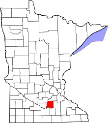 | |
| Townships | ||
| Unincorporated communities | ||
| Footnotes | ‡This populated place also has portions in an adjacent county or counties | |
Coordinates: 44°17′33″N 93°57′54″W / 44.29250°N 93.96500°W