Kangiqsualujjuaq
| Kangiqsualujjuaq ᑲᖏᖅᓱᐊᓗᔾᔪᐊᖅ | |
|---|---|
| Northern village municipality | |
 | |
 Kangiqsualujjuaq | |
| Coordinates: 58°41′N 65°57′W / 58.683°N 65.950°WCoordinates: 58°41′N 65°57′W / 58.683°N 65.950°W[1] | |
| Country |
|
| Province |
|
| Region | Nord-du-Québec |
| TE | Kativik |
| Constituted | February 2, 1980 |
| Government[2] | |
| • Mayor | Hilda Snowball |
| • Federal riding | Abitibi—Baie-James—Nunavik—Eeyou |
| • Prov. riding | Ungava |
| Area[2][3] | |
| • Total | 35.50 km2 (13.71 sq mi) |
| • Land | 35.05 km2 (13.53 sq mi) |
| Population (2011)[3] | |
| • Total | 874 |
| • Density | 24.9/km2 (64/sq mi) |
| • Change (2006–11) |
|
| • Dwellings | 191 |
| Time zone | EST (UTC−5) |
| • Summer (DST) | EDT (UTC−4) |
| Postal code(s) | J0M 1N0 |
| Area code(s) | 819 |
| Website |
www |
Kangiqsualujjuaq (Inuktitut: ᑲᖏᖅᓱᐊᓗᔾᔪᐊᖅ; also Kangirsualujjuaq ᑲᖏᕐᓱᐊᓗᔾᔪᐊᖅ) is an Inuit village located on the east coast of Ungava Bay at the mouth of the George River, in Nunavik, Quebec, Canada. Its population in the Canada 2011 Census was 874.
The community has also been known as Fort Severight, Fort George River, George River, and Port-Nouveau-Québec. The name "Kangiqsualujjuaq" means "the very large bay" in Inuktitut.
Industries in Kangiqsualujjuaq include hunting of caribou, seal and beluga whale, Arctic char fishing, and the production of Inuit art.
The town is also the main terminus of the George River canoeing expeditions (e.g. one of Chewonki Foundation's canoe trips).
It is served by the small Kangiqsualujjuaq Airport.
Description of the township

.jpg)
Kangiqsualujjuaq is located 1,688 km (1,049 mi) to the northeast of Montreal. Access to the township is by plane, although Kangiqsualujjuamiut occasionally travel to Kuujjuaq in winter by snowmobile and in summer by boat, a journey of approximately 160 km (99 mi) to the southwest. Journeys across the Torngat Mountains by snowmobile to the Labrador settlements Nain and Nachvak are rarely embarked upon these days, but were commonplace when dog teams were used. Cargo ships from Montreal deliver cumbersome supplies and equipment to the community every summer.
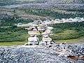
Enveloped by mountains, the township is framed by picturesque surroundings and its elevated position affords unobstructed views of the George River. The town itself is laid out on a grid pattern over levelled-ground, with two unsealed roads leading a few kilometres beyond the mountain ridges at either end of the village.
Amidst rocky outcrops and stone way-finding markers (Inukshuk), the village landscape is dotted with stands of stunted trees and prostrate groundcovers that cling perilously to the rugged granite terrain. In low-lying areas, the ground is covered by thick carpets of moss and lichen.
History
The Hudson's Bay Company operated a post south of today's village (at 58:31:43.03 N 65:53:34.58 W, marked as Illutaliviniq on topographic maps) during the periods of 1838-42, 1876-1915 and 1923-32. But the Inuit of the area never settled around the post, preferring to live along the coast in summer and setting their camps about 50 km (31 mi) km inland in winter. In 1959, local Inuit established, on their own initiative, the first co-operative in Northern Quebec for the purpose of marketing Arctic char. Construction of the village began in 1962 and from then on Inuit began to settle permanently there. In 1963 a school, a co-operative store, and government buildings were built. In 1980, Kangiqsualujjuaq was legally established as a municipality.
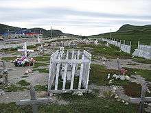
The community was stricken by an avalanche in the early morning of January 1, 1999, which destroyed the Satuumavik School gymnasium during New Year celebrations, killing nine.[4] Another 25 people were injured, 12 of them seriously enough to have to be airlifted 1,500 km to Montreal for treatment. Some speculated that it may have been triggered by lively dancing at the party.[5] The school was rebuilt on the new, safer location and renamed to Ulluriaq School.
Notable and historical people
Inuit Elders
- Noah Angnatuk
- George Annanack
- Johnny Sam Annanack
- Maggie Annanack (Elsie Imaq)
- Sarah Annanack
- Willie Emudluk
- Benjamin Jararuse
- Tivi Etok
- Willie Etok
Explorers and Missionaries
Non-Inuit residents
Images
| Wikimedia Commons has media related to Kangiqsualujjuaq. |
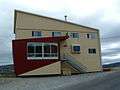 Kangiqsualujjuaq Hotel
.jpg) Streets of Kangiqsualujjuaq
Streets of Kangiqsualujjuaq Kangiqsualujjuaq at night
 Kangiqsualujjuaq
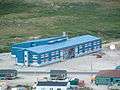 Ulluriaq School
 Kangiqsualujjuaq hockey rink
References
- ↑ Reference number 97009 of the Commission de toponymie du Québec (French)
- 1 2 Geographic code 99090 in the official Répertoire des municipalités (French)
- 1 2 "(Code 2499090) Census Profile". 2011 census. Statistics Canada. 2012.
- ↑ "Avalanche!". CBC. Retrieved 2010-02-10.
- ↑ "Avalanche in Quebec". The Canadian Encyclopedia. Retrieved 2010-02-10.
External links
- Kativik Regional Government
- Nunavik tourism - Kangiqsualujjuaq website
- Kangiqsualujjuaq, Quebec Statistics Canada
- Ulluriaq School, Kangiqsualujjuaq
- Inuit Knowledge and Perceptions of the Land-Water Interface, a comprehensive study of the Kangiqsualujjuaq people and their knowledge and perceptions of their homelands by Scott Heyes (2007)
- Schooling the North