Nunavik
| Nunavik ᓄᓇᕕᒃ | ||
|---|---|---|
| Proposed autonomous area | ||
|
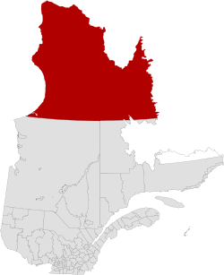
Nunavik's located in Quebec, Canada. | ||
| ||
| Country | Canada | |
| Province | Quebec | |
| Capital | Kuujjuaq | |
| Government | ||
| • MNA | Jean Boucher (since 2014) | |
| • MP | Roméo Saganash (since 2011) | |
| Population (2011) | ||
| • Total | 12,090 | |
| Time zone | EST (UTC-05) | |
| Federal riding | Abitibi—Baie-James—Nunavik—Eeyou | |
| Provincial riding | Ungava (electoral district) | |

Nunavik (Inuktitut: ᓄᓇᕕᒃ) comprises the northern third of the province of Quebec, Canada in Kativik, part of the Nord-du-Québec region. Covering a land area of 443,684.71 km2 (171,307.62 sq mi) north of the 55th parallel, it is the homeland of the Inuit of Quebec. Almost all of the 12,090 inhabitants (2011 census) of the region, of whom 90% are Inuit,[1] live in fourteen northern villages on the coast of Nunavik and in the Cree reserved land (TC) of Whapmagoostui, near the northern village of Kuujjuarapik.
Nunavik means "great land" in the local dialect of Inuktitut and the Inuit inhabitants of the region call themselves Nunavimmiut. Until 1912, the region was part of the District of Ungava of the Northwest Territories.
Negotiations for regional autonomy and resolution of outstanding land claims took place in the 2000s.[2][3] The seat of government would be Kuujjuaq.[4] Negotiations on better empowering Inuit political rights in their land are still ongoing.[5]
A flag for Nunavik was proposed by Nunavik's own artist and graphic designer Thomassie Mangiok during an April 2013 Plan Nunavik consultation in Ivujivik. The proposal was announced in the meeting and then through Nunatsiaq News,[6] the explanation of design was also made available on YouTube.
Geography
.jpg)
Nunavik is a vast territory, larger than the U.S. state of California, located in the northernmost part of Quebec. It lies in both the Arctic and subarctic climate zones. All together, about 12,000 people live in Nunavik's communities, and this number has been growing.
Nunavik is separated from the territory of Nunavut by Hudson Bay to the west and Hudson Strait and Ungava Bay to the north. Nunavik shares a border with the Côte-Nord region of Quebec and the Labrador region of the province of Newfoundland and Labrador. The Ungava Peninsula forms the northern two-thirds of the region.
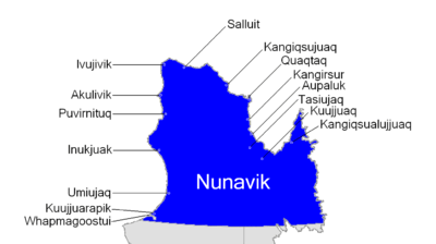
Nunavik has fourteen villages, populated by an Inuit majority. The principal village and administrative centre in Nunavik is Kuujjuaq, on the southern shore of Ungava Bay; the other villages are Inukjuak (where the film Nanook of the North was shot), Salluit, Puvirnituq, Ivujivik, Kangiqsujuaq, Kangiqsualujjuaq, Kangirsuk, Tasiujaq, Aupaluk, Akulivik, Quaqtaq, Kuujjuarapik and Umiujaq. The village population (census 2011) ranges from 2,375 (Kuujjuaq) to 195 (Aupaluk).
There are no road links between Nunavik and southern Quebec, although the Trans-Taiga Road of the Jamésie region ends near the 55th parallel on the Caniapiscau Reservoir, several hundred kilometers south of Kuujjuaq. There is a year-round air link to all villages and seasonal shipping in the summer and autumn. Parts of the interior of southern Nunavik can be reached using several trails which head north from Schefferville.
There are three meteor craters in Nunavik: Pingualuit crater, Couture crater, and La Moinerie crater.
The climate of Nunavik is a severe one dominated by the long and bitterly cold winters as the sea both to the west, east and north freezes over, eliminating maritime moderation. Since this moderation exists in summer when the surrounding sea thaws, even those temperatures are subdued. Inukjuak for example has summer highs averaging just 13 °C (55 °F) with January highs of −21 °C (−6 °F).[7] This is exceptionally cold for a sea-level settlement more than 1/3 from the North Pole en route to the Equator. Annual temperatures are up to 15 °C colder than marine areas of Northern Europe on similar parallels. Areas less affected by summertime marine moderation have somewhat warmer temperatures and unlike the west coast, features marginal taiga due to summers being warmer than 10 °C (50 °F) in mean temperatures.
History
Federal government geopolitical manoeuvrings forced several Inuit families to leave Nunavik in the 1950s. They were transported much further north, to barren hamlets at Grise Fiord and Resolute in what is now Nunavut in an effort to assert sovereignty in the High Arctic by increasing its population during the Cold War. Eight Inuit families from Inukjuak (on the Ungava Peninsula) were relocated after being promised homes and game to hunt, but the relocated people discovered no buildings and very little familiar wildlife.[8] They were told that they would be returned home to Nunavik after a year if they wished, but this offer was later withdrawn as it would damage Canada's claims to sovereignty in the High Arctic area and the Inuit were forced to stay. Eventually, the Inuit learned the local beluga whale migration routes and were able to survive in the area, hunting over a range of 18,000 km2 (6,900 sq mi) each year.[9]
In 1993, the Canadian government held hearings to investigate the relocation program. The Royal Commission on Aboriginal Peoples issued a report the following year entitled The High Arctic Relocation: A Report on the 1953-55 Relocation.[10] The government paid $10 million CAD to the survivors and their families, and finally apologized in 2010.[11]
The whole story is told in Melanie McGrath's The Long Exile: A Tale of Inuit Betrayal and Survival in the High Arctic.[12]
Government
Nunavik, along with the James Bay region (or Jamésie), is part of the administrative region of Nord-du-Québec.
The James Bay and Northern Quebec Agreement of 1978 led to greater political autonomy for most of the Nunavik region with the founding of the Kativik Regional Government. All inhabitants of the 14 northern villages, both Inuit and non-Inuit, vote in regional elections. The Kativik Regional Government is financed by the Government of Quebec (50%), the Government of Canada (25%), and local revenues (25%).
The Makivik Corporation, headquartered in Kuujjuaq, represents the Inuit of Northern Quebec in their relations with the governments of Quebec and Canada. They are seeking greater political autonomy for the region and have recently negotiated an agreement defining their traditional rights to use the resources of the offshore islands of Nunavik, all of which are part of Nunavut.
The Cree village of Whapmagoostui, which forms an enclave on the eastern shore of Hudson Bay near the northern village of Kuujjuarapik, is part of the Cree Regional Authority, which itself has been incorporated into the Grand Council of the Crees (Eeyou Istchee). The Naskapi Nation of Kawawachikamach, of the Côte-Nord region to the south of Nunavik, owns an exclusive hunting and trapping area in southern Nunavik and is represented in the Kativik Regional Government.
Regional Government of Nunavik
The governments of Quebec and Canada and Nunavik had negotiated a proposal to establish a Regional Government of Nunavik. While Quebec and Canada would still maintain full jurisdiction over the area, the Nunavik government will have an elected parliamentary-style council and cabinet, and a public service funded by the province and responsible for delivering certain social services such as education and health. The regional government would have also had rights to the region's natural resources, including royalties from the various mines in the region. This proposal was rejected by about 66% of voters in a referendum in 2011. It is expected that negotiations will continue in the future to work to establish a more autonomous government for Nunavik in the future.
The government will be based on territory, not ethnicity, so that all people residing in Nunavik can be full participants.[13] Existing government structures, such as the Kativik Regional Government, Kativik School Board, and Nunavik Regional Board of Health and Social Services, will be folded into the new regional government.
The Quebec government has also expressed a desire to add an additional seat to the National Assembly to represent Nunavik, despite the region's small population. Currently, Nunavik is part of the riding of Ungava, its residents making up just under half of the riding's population. As a riding, Nunavik would be the second least populous in Quebec, slightly more populous than Îles-de-la-Madeleine, which is able to exist as a separate riding under an exception to the laws on population distribution by riding.[14]
Economy
Nunavik is rich in mineral deposits.
Raglan Mine, situated near Salluit, is one of the largest. It is linked by all-weather roads to an airstrip at Kattiniq/Donaldson Airport and to the concentrate, storage and ship-loading facilities at Deception Bay. Production began at the mine in 1997. The current mine life is estimated at more than 30 years.
Because the site is situated in the subarctic permafrost region, it requires unique construction and mining techniques to protect the fragile permafrost and to address other environmental issues. The average annual temperature is −10 °C (14 °F) with an average ambient temperature underground of −15 °C (5 °F).
There are plans to increase production at a new mine in Raglan South. A major investment is planned in the next quarter as many companies are planning to bid.
Communities
- Akulivik (Akulivik (Inuit reserved land))
- Aupaluk (Aupaluk (Inuit reserved land))
- Inukjuak (Inukjuak (Inuit reserved land))
- Ivujivik (Quebec's northernmost settlement)
- Kangiqsualujjuaq (Kangiqsualujjuaq (Inuit reserved land))
- Kangiqsujuaq (Kangiqsujuaq (Inuit reserved land))
- Kangirsuk (Kangirsuk (Inuit reserved land))
- Kuujjuaq (administrative centre, Kuujjuaq (Inuit reserved land))
- Kuujjuarapik/Whapmagoostui (a bicultural community of Inuit and Cree, Kuujjuarapik (Inuit reserved land))
- Puvirnituq
- Quaqtaq (Quaqtaq (Inuit reserved land))
- Salluit (Salluit (Inuit reserved land))
- Tasiujaq (Tasiujaq (Inuit reserved land))
- Umiujaq (Umiujaq (Inuit reserved land))
- Whapmagoostui/Kuujjuarapik (a bicultural community of Inuit and Cree)
See also
- Taqramiut Nipingat
- Tursujuq National Park
- List of proposed provinces and territories of Canada
- Nunatsiavut
Notes
- ↑ "Aboriginal Peoples in Canada in 2006: Inuit, Métis and First Nations, 2006 Census: Inuit: Inuit population: Young and growing". Statistics Canada. Retrieved 2008-04-11.
- ↑ Nunavik Government | The Agreement in Principle and Where It's At
- ↑ Curry, Bill (2007-08-13). "Quebec Inuit to sign historic self-governance agreement". Toronto: The Globe and Mail. Retrieved 2007-08-13.
- ↑ "Inuit poised to gain control of large territory in Quebec". CBC News. 2007-08-13. Archived from the original on March 9, 2008. Retrieved 2007-08-13.
- ↑ "Que. Inuit vote against self-government plan". CBC News.
- ↑ "A Nunavik flag could inspire the region: designer". Nunatsiaq News.
- ↑ "Canadian climate normals 1971-2000 station data". Environment Canada. Retrieved 30 September 2015.
- ↑ Grise Fiord: History
- ↑ McGrath, Melanie. The Long Exile: A Tale of Inuit Betrayal and Survival in the High Arctic. Alfred A. Knopf, 2006 (268 pages) Hardcover: ISBN 0-00-715796-7 Paperback: ISBN 0-00-715797-5
- ↑ The High Arctic Relocation: A Report on the 1953-55 Relocation by René Dussault and George Erasmus, produced by the Royal Commission on Aboriginal Peoples, published by Canadian Government Publishing, 1994 (190 pages)
- ↑ "Inuit receive apology for forced relocation". CBC. 2010-08-18. Archived from the original on August 21, 2010. Retrieved 2010-08-18.
- ↑ Alfred A. Knopf, 2006 (268 pages) Hardcover: ISBN 0-00-715796-7 Paperback: ISBN 0-00-715797-5
- ↑ Makivik Corporation; Government of Quebec; Government of Canada (11 July 2007). "Agreement in Principle Concerning the Amalgamation of Certain Public Institutions and Creation of the Nunavik Regional Government" (PDF) (in French, Inuktitut, and English). The Nunavik Regional Government negotiations website. p. 8. Retrieved 23 September 2009.
The Nunavik Regional Government shall be a public institution for all Nunavik residents, notably regarding the access to services and the eligibility for positions and responsibilities.
- ↑ Chouinard, Tommy. Les Inuits auront leur gouvernement régional. La Presse, 6 December 2007.
Further reading
- Chabot, Marcelle (2004). Consumption and Standards of Living of the Québec Inuit: Cultural Permanence and Discontinuities. Canadian review of sociology and anthropology,41 (2): 147-170.
- Chabot, M. (2003). Economic Changes, Household Strategies and Social Relations of Contemporary Nunavik Inuit. Polar Record 39(208): 19-34.
- Dana, Leo Paul 2010, “Nunavik, Arctic Quebec: Where Co-operatives Supplement Entrepreneurship,” Global Business and Economics Review 12 (1/2), January 2010, pp. 42–71.
- Greene, Deirdre, D. W. Doidge, and Ray Thompson. An Overview of Myticulture with Particular Reference to Its Potential in Nunavik. Kuujjuaq, Quebec: Kuujjuaq Research Centre, Makivik Corp, 1996.
- Hodgins, Stephen. Health and what affects it in Nunavik how is the situation changing? Kuujjuaq, [Quebec]: Nunavik Regional Board of Health and Social Services, 1997. ISBN 2-9803354-2-8
- Reeves, Randall R., and Stanislaw Christopher Olpinski. Walruses of Nunavik = Les morses du Nunavik. [Kuujjuaq, Quebec]: Makivik Corporation, 1995.
- Reeves, Randall R., and Stanislaw Christopher Olpinski. Belugas (white whales) in Nunavik = Les bélugas (baleines blanches) au Nunavik. [Kuujjuaq, Quebec]: Makivik Corporation, 1995.
External links
- Kativik Regional Government website
- Nunavik Marine Region Planning Commission website
- Interactive map of information on Nunavik communities
- Makivik Corporation
- Northern Quebec at DMOZ
| National | |
|---|---|
| Provinces | |
| Territories | |
| See also | |
| |
Arctic topics | |
|---|---|
| History |
|
| Government | |
| Geography |
|
| Regions | |
| Climate | |
| Fauna | |
| Flora | |
| Culture | |
| Economy |
|
| Transport | |
| |
| Regional county municipalities and equivalent territories |
|
|---|---|
| Municipalities | |
| Subdivisions | |
|---|---|
| Communities | |
| Major cities | |
Coordinates: 55°00′N 64°00′W / 55.000°N 64.000°W