Kale, Malatya
| Kale | |
|---|---|
 Kale | |
| Coordinates: 38°24′58″N 38°46′00″E / 38.41611°N 38.76667°ECoordinates: 38°24′58″N 38°46′00″E / 38.41611°N 38.76667°E | |
| Country | Turkey |
| Province | Malatya |
| Government | |
| • Mayor | Cemal Akdemir (AKP) |
| • Kaymakam | Osman Bilgin |
| Area[1] | |
| • District | 193.07 km2 (74.54 sq mi) |
| Population (2012)[2] | |
| • Urban | 1,681 |
| • District | 5,917 |
| • District density | 31/km2 (79/sq mi) |
| Post code | 4437x |
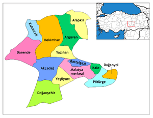
Kale, (Kurdish: Qela or Îzolî), is a district of Malatya Province of Turkey. The mayor is Cemal Akdemir (AKP).
The old name "İzollu" is no longer used, although it is still known locally by that name. Tribal people of the area identify themselves as Izol. The district's population is mostly of Sunni Kurdish origin. Its new name, Kale, which means "castle", came from an old castle in the district. It is the richest and the lushest district of Malatya. Remains of the Karakaya Dam under the tumulus Pirot are shown in the region since ancient times.
Kale's population is about 4,000, dispersed throughout the district. The basic livelihoods of the town are strawberry production and animal husbandry. Districts already connected to the center of a region, while the 1990 has earned the status of the county by law.
References
- ↑ "Area of regions (including lakes), km²". Regional Statistics Database. Turkish Statistical Institute. 2002. Retrieved 2013-03-05.
- ↑ "Population of province/district centers and towns/villages by districts - 2012". Address Based Population Registration System (ABPRS) Database. Turkish Statistical Institute. Retrieved 2013-02-27.