Kalangala
| Kalangala | |
|---|---|
|
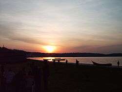
Kalangala beach overlooking the lake at sunset | |
 Kalangala Location in Uganda | |
| Coordinates: 00°19′17″S 32°17′31″E / 0.32139°S 32.29194°E | |
| Country |
|
| Region | Central Uganda |
| District | Kalangala District |
| Elevation | 1,220 m (4,000 ft) |
| Population (2011 Estimate) | |
| • Total | 5,200 |
Kalangala is a town in Kalangala District in the Central Region of Uganda. It is the headquarters of the district.
Location
Kalangala is on the northern shore of Bugala Island, the largest of the Ssese Islands in Lake Victoria. It is approximately 60 kilometres (37 mi), across water, southwest of Entebbe.[1] The coordinates of the town are0°19'17.0"S, 32°17'31.0"E (Latitude:-0.321389; Longitude:32.291944).[2]
Overview
Kalangala is on the northern beach of Bugala Island, which constitutes the bulk (68.5 percent) of the land mass of Kalangala District.
Population
The 2002 national census estimated the population of the town at 2,950. In 2010, the Uganda Bureau of Statistics (UBOS) estimated the population of the town at 4,900. In 2011, UBOS estimated the mid-year population at 5,200.[3]
Points of interest
The following points of interest lie within the town limits or close to the edges of town:
- Kalangala Information Center
- Kalangala central market
- offices of Kalangala Town Council
See also
External links
References
- ↑ "Distance between Entebbe and Kalangala with Map". Globefeed.com. Retrieved 9 May 2014.
- ↑ Google (12 July 2015). "Location of Kalangala Town at Google Maps" (Map). Google Maps. Google. Retrieved 12 July 2015.
- ↑ UBOS (2012). "Estimated Population of Kalangala In 2002, 2010 & 2011" (PDF). Uganda Bureau of Statistics (UBOS). Retrieved 12 July 2015.
Capital: Kalangala | ||
| Counties and sub-counties |  | |
| Towns and villages | ||
| Geography | ||
| Economy |
| |
| Energy | ||
| Notable landmarks | ||
| Notable people | ||
Coordinates: 00°19′17″S 32°17′31″E / 0.32139°S 32.29194°E Central Region, Uganda