Kaiwaka
| Kaiwaka | |
|---|---|
 Kaiwaka | |
| Coordinates: 36°9′40″S 174°26′37″E / 36.16111°S 174.44361°ECoordinates: 36°9′40″S 174°26′37″E / 36.16111°S 174.44361°E | |
| Country | New Zealand |
| Region | Northland Region |
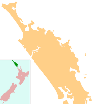
| District | Kaipara District |
| Population (2006) | |
| • Total | 537 |

Kaiwaka "the little town of lights" is a settlement in Northland, New Zealand. The Kaiwaka River runs from the east through the area and joins with the Wairau River to form the Otamatea River, which drains into the Kaipara Harbour. State Highway 1 passes through Kaiwaka. Wellsford is 20 km south, Brynderwyn is 8 km north and Whangarei the closest city, being 60 km (45 minutes drive) north. The Mangawhai Heads are 18 km north east.[1][2]
The population was 537 in the 2006 Census, unchanged from 2001.[3]
History
In February 1825, during the Musket Wars, a major battle between Ngā Puhi and Ngāti Whātua at Te Ika-a-ranga-nui near Kaiwaka resulted in over 170 deaths.[4][5]
Kaiwaka became a trading and commercial point from the late 1850s.[6] As the kauri timber and gum industries declined towards the end of the century, dairy farming became established. The Hakaru Dairy Company was formed to serve Kaiwaka farmers in 1902.[7]
From the 1880s, steamers provided regular service to Kaiwaka from the Otamatea. The Minnie Casey ran a service every Tuesday from 1882. Services continued well into the 20th century.[8]
The Great North Road from Auckland to Whangarei passed through Kaiwaka, but was only a line on a map for much of the 19th century. Attempts were made to improve the road from 1895, and by 1900 the worst places on the road between Kaiwaka and Whangarei were metalled.[9] In 1911, Kaiwaka had a population of 211.[10]
The North Auckland railway line reached Kaiwaka in March 1913, although problems with the terrain, and World War I, meant that it was not extended significantly further north until the early 1920s.[11]
The Lands and Survey Department took over large blocks of unproductive land and developed them in the 1940s, and these were passed to returning soldiers in the early 1950s.[12]
Notable people
- Mary Jane Mander, journalist and novelist, attended school in Kaiwaka.[13]
- Tapihana Paraire Paikea, Member of Parliament for Northern Maori, died at Kaiwaka.
- Peter Panyoczki, visual artist, is a resident of Kaiwaka.
Education
Kaiwaka School is a coeducational contributing primary (years 1-6) school with a decile rating of 4 and a roll of 90.[14] The school opened in September, 1871,[15] and the school celebrated its centennial in 1970.[16]
See also
Notes
- ↑ Peter Dowling (editor) (2004). Reed New Zealand Atlas. Reed Books. pp. map 8. ISBN 0-7900-0952-8.
- ↑ Roger Smith, GeographX (2005). The Geographic Atlas of New Zealand. Robbie Burton. pp. map 31. ISBN 1-877333-20-4.
- ↑ Quickstats about Kaiwaka
- ↑ Byrne, Brian (2002). The Unknown Kaipara. pp. 25–26. ISBN 0-473-08831-2.
- ↑ Stone, Russell (2001). From Tamaki-Makau-Rau to Auckland. pp. 100–101.
- ↑ Ryburn, Wayne (1999). Tall Spars, Steamers & Gum. p. 23. ISBN 0-473-06176-7.
- ↑ Ryburn, p 65
- ↑ Ryburn, pp 75, 79, 80-81, 176
- ↑ Ryburn, pp 16, 91
- ↑ Ryburn, p 162
- ↑ Ryburn, p 184-185
- ↑ Ryburn, p 168
- ↑ "Mander, Mary Jane 1877 - 1949". Dictionary of New Zealand Biography.
- ↑ "Te Kete Ipurangi - Kaiwaka School". Ministry of Education.
- ↑ Ryburn, p 46
- ↑ Littin, Jackson William (1970). The History of Education in the Kaiwaka District: 100 Years of Progress. Kaiwaka School Centennial Committee.