K-60 (Kansas highway)
| ||||
|---|---|---|---|---|
 | ||||
| Route information | ||||
| Maintained by KDOT | ||||
| Length: | 4.284 mi[1] (6.894 km) | |||
| Major junctions | ||||
| South end: |
| |||
| East end: |
| |||
| Highway system | ||||
| ||||

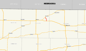
K-60 is a 4.284-mile-long (6.894 km) state highway in the U.S. state of Kansas. It runs from U.S. Route 36 (US 36) north to K-383 near Almena. The route was established around 1930.
Route description
K-60 begins at an intersection with US 36 11 miles east of Norton and 19 miles west of Phillipsburg . The highway heads north, surrounded by a grassland terrain marked with several fields. The road turns northwestward. After an intersection with Main Street, K-60 turns back northward towards Almena.[2] The highway ends at an intersection with K-383 near the Kyle Railroad.[3]
The route is maintained by the Kansas Department of Transportation (KDOT), who is responsible for constructing and maintaining highways in the state. As part of this role, KDOT regularly surveys traffic on their highways. These surveys are most often presented in the form of annual average daily traffic, which is the number of vehicles that use a highway during an average day of the year. In 2010, KDOT calculated that a total of 115 vehicles used the road daily, including 20 trucks.[4] No part of the highway has been listed as part of the National Highway System, a network of roads important to the nation's defence, mobility, and economy.[5]
History
K-60 was built and established between 1927 and 1932 by the Kansas State Highway Commission, who was at the time responsible for maintaining highways in Kansas.[6][7] At this time, the road was surfaced with gravel. The entire route was paved between 1948 and 1950.[8][9] Since then, the road's designation has not been changed.[2]
Major intersections
The entire route is in Almena Township, Norton County.
| mi[1] | km | Destinations | Notes | ||
|---|---|---|---|---|---|
| 0.000 | 0.000 | Southern terminus | |||
| 4.284 | 6.894 | Northern terminus | |||
| 1.000 mi = 1.609 km; 1.000 km = 0.621 mi | |||||
References
- 1 2 Kansas Department of Transportation. "2010 Condition Survey Report for Norton County, Kansas". Retrieved March 31, 2011.
- 1 2 Google (April 6, 2011). "K-60" (Map). Google Maps. Google. Retrieved April 6, 2011.
- ↑ Kansas State Railroad Map (Map). Cartography by Bureau of Transportation Planning. Kansas Department of Transportation. April 1, 2011. Retrieved April 1, 2011.
- ↑ Traffic Flow Map of the Kansas State Highway System (Map). Cartography by Bureau of Transportation Planning. Kansas Department of Transportation. 2011.
- ↑ National Highway System: Kansas (PDF) (Map). Federal Highway Administration. Retrieved March 30, 2011.
- ↑ Junior Auto Road Map of Kansas (Map). Rand McNally. 1927. Retrieved April 1, 2011.
- ↑ Kansas State Highway System (Map). Kansas State Highway Commission. April 1, 1932.
- ↑ Kansas State Highway System (Map). Kansas State Highway Commission. 1948. § B5.
- ↑ Official Kansas Highway Map (Map). Kansas State Highway Commission. 1950–1951. § B5.
External links