John Senex
John Senex (1678, London – died 1740, London) was an English cartographer, engraver and explorer.
He was also an astrologer, geologist, and geographer to Queen Anne of Great Britain,[1] editor and seller of antique maps and most importantly creator of the pocket-size map of the world. He owned a business on Fleet Street, where he sold maps.[1]
Importance
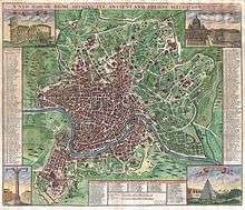
He was one of the principal cartographers of the 18th century. He started his apprenticeship with Robert Clavell, at the Stationers Company, in 1692. Senex is famous for his maps of the world, some of which have added elevations, and which feature minuscule detailed engravings. Many of these maps can be found in museum collections; rarely, copies are available for private sale. Some copies are held in the National Maritime Museum; many of his maps are now in the possession of Trinity College Dublin. Having worked and collaborated with Charles Price, Senex created a series of engravings for the London Almanacs and in 1714 he published together with Maxwell an English Atlas. In 1719 he published a miniature edition of Brittania by Ogilby. He became particularly interested in depicting California as an island instead of part of mainland North America, a trait which makes many of his maps appealing to collectors. In 1721 he published a new general atlas. He used the work of cartographer Guillaume de L’Isle as an influence.[1]
In 1728 Senex was elected into the Fellowship of the Royal Society of London.[1]
See also
| Wikisource has the text of the 1885–1900 Dictionary of National Biography's article about Senex, John. |
| Wikimedia Commons has media related to John Senex. |
References
Footnotes
Bibliography
- Worms, Laurence. "Senex, John". Oxford Dictionary of National Biography (online ed.). Oxford University Press. doi:10.1093/ref:odnb/25085. (Subscription or UK public library membership required.)