Willem Blaeu
| Willem Janszoon Blaeu | |
|---|---|
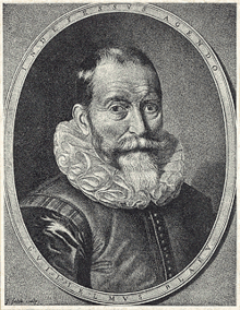 Willem Janszoon Blaeu by Jeremias Falck | |
| Born |
1571 Holland, Seventeen Provinces |
| Died |
21 October 1638 (age 67) Amsterdam, Holland, Dutch Republic |
| Nationality | Dutch |
| Occupation | Cartographer, atlas maker, publisher |

Willem Janszoon Blaeu (Dutch pronunciation: [ˈʋɪləm ˈjɑnsoːm ˈblʌu];[1] 1571 – 21 October 1638), also abbreviated to Willem Jansz. Blaeu, was a Dutch cartographer, atlas maker and publisher.
Biography
Blaeu was born at Uitgeest or Alkmaar. As the son of a well-to-do herring salesman, he was destined to succeed his father in the trade, but his interests lay more in mathematics and astronomy. Between 1594 and 1596, as a student of the Danish astronomer Tycho Brahe, he qualified as an instrument and globe maker.[2] In 1600 he discovered the second ever variable star, now known as P Cygni.
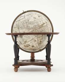
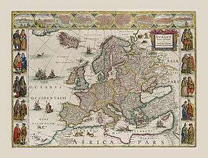
Once he returned to Holland, he made country maps and world globes, and as he possessed his own printing works, he was able to regularly produce country maps in an atlas format, some of which appeared in the Atlas Novus published in 1635. In 1633 he was appointed map-maker of the Dutch East India Company. He was also an editor and published works of Willebrord Snell, Descartes, Adriaan Metius, Roemer Visscher, Gerhard Johann Vossius, Barlaeus, Hugo Grotius, Vondel and the historian and poet Pieter Corneliszoon Hooft. He died in Amsterdam.
He had two sons, Johannes and Cornelis Blaeu, who continued their father's mapmaking and publishing business after his death in 1638. Prints of the family's works are still sold today. Original maps are rare collector items.
Blaeu's maps were featured in the works of the Dutch painter Johannes Vermeer of Delft (1632–1675), who holds a position of great honor among map historians. Several of his paintings illustrate maps hanging on walls or globes standing on tables or cabinets. Vermeer painted these cartographical documents with such detail that it is often possible to identify the actual maps. Evidently, Vermeer was particularly attached to a Willem Blaeu – Balthasar Florisz van Berckenrode map of Holland and West Friesland, as he represented it as a wall decoration in three of his paintings. Though no longer extant, the map's existence is known from archival sources and the second edition published by Willem Blaeu in 1621, titled Nova et Accurata Totius Hollandiae Westfriesiaeq. Topographia, Descriptore Balthazaro Florentio a Berke[n]rode Batavo. Vermeer must have had a copy at his disposal (or the earlier one published by Van Berckenrode). Around 1658 he showed it as a wall decoration in his painting Officer and Laughing Girl, which depicts a soldier in a large hat sitting with his back to viewer, talking with a smiling girl who holds a glass in her hand. Bright sunlight bathes the girl and the large map on the wall. Vermeer's gift for realism is evidenced by the fact that the wall map, mounted on linen and wooden rods, is identifiable as Blaeu's 1621 map of Holland and West Friesland. He captures faithfully its characteristic design, decoration, and geographic content.[3]
Legacy
His maps formed the bulk of the Atlas Maior, that became a collector's item in Amsterdam. One of Blaeu's globes was purchased at auction by Maarten Magielse, a Dutch salesman, for the record price of €60,000, about US$80,000. Magielse is now lending it to the globe museum in Vienna, where it is being exhibited.
Works published by Willem Blaeu
- Aardglobe (1599)
- Hemelglobe (1603)
- Nieuw Graetboeck (1605)
- Nywe Paskaerte (1606)
- 't Licht der zeevaert (1608)
- Spieghel der Schrijfkonste (1609) [4]
- "Nova et Accurata Totius Hollandiae Westfriesiaeq. Topographia, Descriptore Balthazaro Florentio a Berke[n]rode Batavo"
- Tafelen van de declinatie der Sonne (1623)
- Tafelen van de breedte van de opgang der Sonne
- Zeespiegel, inhoudende een korte onderwysinghe inde konst der zeevaert, en beschryvinghe der seen en kusten van de oostersche, noordsche, en westersche schipvaert (1624)
- Pascaarte van alle de zeecusten van Europa (1625)
- Tweevoudigh onderwijs van de Hemelsche en Aerdsche globen; het een na de meyning van Ptolemævs met een vasten aerdkloot; het ander na de natuerlijcke stelling van N. Copernicus met een loopenden aerdkloot.
- Atlantis Appendix (1630)
- Appendix Theatri ... et Atlantis ... (1631)
- Atlas (1634)
- Novus Atlas (1635)
- Theatrum Orbis Terrarum (1635)
- Toonneel des Aerdrycks (1635)
- Le Theatre du Monde (1635)
- Theatre du monde ou Nouvel Atlas (1638)
Canon of Amsterdam
- Firma Blaeu is window nummer 18 in the Canon of Amsterdam.
See also
Literature
- Krogt, van der, Peter CJ (2000), Koeman's Atlantes Neerlandici II: The Folio Atlases Published by Willem Jansz. Blaeu and Joan Blaeu, Houten: Hes & De Graaf publishers BV, ISBN 90-6194-438-4
- P. J. H. Baudet: Leven en werken van Willem Jansz. Blaeu, Utrecht 1871.
- Johannes Keuning and Marijke Donkersloot-de Vrij (Edited): Willem Jansz. Blaeu: a biography and history of his work as cartographer and publisher, Amsterdam 1973. ISBN 90-221-1253-5
References
- ↑ Janszoon in isolation: [ˈjɑnsoːn].
- ↑ Charles W. J. Withers, Hayden Lorimer (2008). GEOGRAPHERS: BIOBIBLIOGRAPHICAL STUDIES, Volume 27. Continuum International Publishing Group. p. 14. ISBN 1-84706-156-7.
- ↑ van der Krogt, Peter. 1998. "Vermeer's Blaeu Period." Mercator's World. Volume 3 (5) September/October 1998. Page 82.
- ↑ http://blogs.princeton.edu/graphicarts/2010/04/
External links
| Wikimedia Commons has media related to Maps by Willem and Johannes Blaeu. |
Information about Willem Blaeu:
- Galileo Project facts on Willem Blaeu
- Literature by and about Willem Blaeu in the German National Library catalogue
Books published by Willem Blaeu:
For maps created by Willem Blaeu, but published by his son Joan Blaeu, go to Joan Blaeu#External links.