Jhelum District
| Jhelum جہلم | |
|---|---|
| District | |
 | |
| Country | Pakistan |
| Province | Punjab |
| Headquarters | Jhelum city |
| Government | |
| • Members of National Assembly | Chaudhry Khadim Hussain (NA-62) |
| Area | |
| • Total | 3,587 km2 (1,385 sq mi) |
| Population (2006) | |
| • Total | 1,103,000 |
| • Density | 261/km2 (680/sq mi) |
| Time zone | PKT (UTC+5) |
| No. of Tehsils | 4 |
| Tehsils |
Jhelum Pind Dadan Khan Sohawa Dina |
| Languages (1981) | 97.5% Punjabi[1] |
| Website |
www |

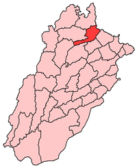
Jhelum District (Urdu: ضلع جہلم) is in Pothohar Plateau of the Punjab province of Pakistan. Jhelum is one of the oldest districts of Punjab. It was established on 23 March 1849.[2] According to the 1998 census, the district had a population of 936,957, of which 31.48% were urban.[3] Jhelum District has a diverse population of 1,103,000 (2006)[4] which mainly consists of Punjabis. Jhelum is known for providing a large number of soldiers to the British and later to the Pakistan armed forces due to which it is also known as city of soldiers or land of martyrs and warriors.[5] The district of Jhelum stretches from the river Jhelum almost to the Indus. Salt is quarried at the Mayo mine in the Salt Range. There are two coal-mines in the district from which the North-Western railway obtains parts of its supply. These are the only coal-mines in Punjab province which are in working condition. The chief centre of the salt trade is Pind Dadan Khan. The district is crossed by the main line of the North-Western railway, and also traversed along the south by a branch line. It is located in the north of the Punjab province, Jhelum district is bordered by Sargodha and Mandi Bahauddin to its south, Khushab to its south west, Jhelum River to its south and east, Gujrat to its east, Chakwal to its west, Mirpur to its north east, and Rawalpindi to its north.
Administration
The district of Jhelum, which covers an area of 3,587 square kilometres (1,385 sq mi),[6] is administratively divided into four tehsils: Jhelum, Sohawa, Pind Dadan Khan and Dina,[7]- which are divided into 53 Union Councils.[8] Jhelum City is the main city of the district.
Language
As per the 1981 census of Pakistan, the following are the demographics of the Jhelum district, by spoken language:
- Punjabi language: 97.5%
- Other: 2.5%[1]
Inhabitants of Jhelum District speak a great variety of Punjabi dialects: which are
- Majhi
- Pothohari[9]
- Shapuri (east side along the river and parts of Tehsil Pind Dadan Khan)
- Dhani (western side along Chakwal).
Among other languages Urdu is spoken and understood by most of the population.
English is also understood and spoken by the educated elite.

First Languages of Jhelum district in 1981
Demographics
The population of Jhelum District according to the 1998 census of Pakistan was 936,957 with a population density of 261 people per square kilometer.[10] Jhelum District has a diverse population of 1,103,000 (2006)[4] which mainly consists of Punjabis. According to Punjab Education Department's annual literacy statistics for 2006, Jhelum had a literacy rate of 79% which is among the highest in Pakistan.[11][12][13] Human Development Index of Jhelum is 0.770, which is highest in Pakistan after Karachi. Based on the surveys of 2004-2005, Jhelum district is considered fourth richest district of Pakistan with about 12.32% of its population living under the poverty line. The top three in the list are Karachi, Lahore and Rawalpindi.[14] According to the Gazetteer of the Jhelum District of 1904, 88.7% of the population were Muslim[15]
History
Early history
The history of the district dates back to the Hindu mythological period of the Mahabharata. The epic represents the Salt Range as the refuge of the five Pandava brethren during the period of their exile, and every salient point in its scenery is connected with some legend of the national heroes. Modern research has fixed the site of the conflict between Alexander and Raja Porus as within Jhelum district, though the exact spot at which the Macedonian king effected the passage of the Jhelum (or Hydaspes) has been hotly disputed. After this event, we have little information with regard to the condition of the district until the Muslim conquest brought back literature and history to Upper India. The Panhwars, Janjuas and Jats, who now hold the Salt Range and its northern plateau respectively, appear to have been the earliest inhabitants[16]
The Janjuas, who appear to represent an the oldest breed of Punjab and who still inhabit a large tract in the east of the District; while the Awans and Ghakars who cluster in the western plain, are apparently later invaders, the Janjuas were the dominant race during the before and early Muslim era and they long continued to retain their independence until they time of Sikh invaders, both in Jhelum itself and in the neighbouring District of Rawalpindi.[16]
Sultanate era

In 997 CE, Sultan Mahmud Ghaznavi, took over the Ghaznavid dynasty empire established by his father, Sultan Sebuktegin, he conquered the Shahis in Kabul in 1005, and followed it by the conquests of northern Punjab region. The Delhi Sultanate and later Mughal Empire ruled the region. The Punjab region became predominantly Muslim due to missionary Sufi saints whose dargahs dot the landscape of Punjab region, which is also reflected in Jhelum. The Jhelum region has also a good number of Arain population. The Arain, descendants of Arabs who entered in Indian Subcontinent with Muhammad Bin Qasim spread here in the reign of Mahmud Ghaznavi due to being in his chivalry.
Mughal era
During the flourishing period of the Mughal dynasty,The Janjuas Rajputs chieftains were among the most prosperous and loyal vassals of the house of Babar. ref Tuzk e Babri
Sikh era
After the decline of the Mughal Empire, the Sikh became in charge of Jhelum District. The lands were owned by Hindu and Sikh rulers and impoverished Muslim landless peasants faced hardships under the Sikh rule.
British era
In 1849, Jhelum, with the other Sikh territories, came under British rule, and started to give aid to impoverished illiterate Muslims peasants who were practically serfs.
The British started to recruit local impoverished peasants into the native army and created an unfounded myth about the 'martial races'.
During British rule Jhelum was a district of Rawalpindi Division, and was larger than the current district of Jhelum. On April 1, 1904, the tehsil of Talagang was detached from the District and incorporated with the new District of Attock.
The old Jhelum district (minus Talagang) covered an area of 2,813 square miles (7285 km2) and included Chakwal Tehsil – it was bordered by Shahpur and Attock to the west, and by Rawalpindi to the north – the Jhelum River separated it from Kashmir to the north-east and from Gujrat and Shahpur to the south-east and south.[16]
Independence
The predominantly Muslim population supported under the leadership of Raja Ghazanfar Ali khan of PD Khan Muslim League and Pakistan Movement. After the independence of Pakistan in 1947, the minority Hindus and Sikhs migrated to India while the Muslim refugees from India settled in the Jhelum District.
Since independence the agriculture and industry of Jhelum developed and forms part of the economy of Pakistan.
Topography
Jhelum City
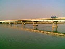
The district capital, Jhelum City, is situated on the right and left bank of the Jhelum River,the left side of Jhelum is known as Sarai Alamgir and it also contain the Military College Jhelum (MCJ). The 16th-century Grand Trunk Road passes through the city. Jhelum city is near the site of the famous Battle of the Hydaspes between the armies of Alexander and Raja Porus This battle took place a few miles downstream from the city center, along the river banks. Population of the Jhelum city (proper) is about 172,073[17] (2009) and it is the 35th largest city of Pakistan by population. A cantonment was built during the British rule, which has grown up into a strong Garrison, with an Infantry Division commanded by a Major General.
River Jhelum
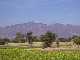
The river Jhelum is navigable throughout the district, which forms the south-eastern portion of a rugged Himalayan spur, extending between the Indus and Jhelum to the borders of the Sind Sagar Doab. Its scenery is very picturesque, although not of so wild a character as the mountain region of Rawalpindi to the north, and is lighted up in places by smiling patches of cultivated valley. The backbone of the district is formed by the Salt Range, a treble line of parallel hills running in three long forks from east to west throughout its whole breadth.
The range rises in bold precipices, broken by gorges, clothed with brushwood and traversed by streams which are at first pure, but soon become impregnated with the saline matter over which they pass. Between the line of hills lies a picturesque table-land, in which the beautiful little lake of Kallar Kahar nestles amongst the minor ridges. North of the Salt Range, the country extends upwards in an elevated plateau, diversified by countless ravines and fissures, until it loses itself in tangled masses of Rawalpindi mountains. In this rugged tract cultivation is rare and difficult, the soil being choked with saline matter. At the foot of the Salt Range, however, a small strip of level soil lies along the banks of the Jhelum, and is thickly dotted with prosperous villages.
The drainage of the district is determined by a low central watershed running north and south at right angles to the Salt Range. The waters of the western portion find their way into the Sohan, and finally into the Indus; those of the opposite slope collect themselves into small torrents, and empty themselves into the Jhelum River.
Khewra Salt Mine

The Khewra Salt Mine (or Mayo Salt Mine) is located in Khewra, north of Pind Dadan Khan,[18] an administrative subdivision of Jhelum District, which rises from the Indo-Gangetic Plain.[19] It is Pakistan's largest and oldest salt mine[20] and the world's second largest.[21][22] It is a major tourist attraction, drawing up to 40,000 visitors a year.[23] Its history dates back to its discovery by Alexander's troops in 320 BC, but it started trading in the Mughal era.[24] The main tunnel at ground level was developed by Dr. H. Warth, a mining engineer, in 1872 during British rule. After independence, the Pakistan Mineral Development Corporation took over the mine, which still remains the largest source of salt in the country, producing more than 350,000 tons per annum[25] of about 99% pure halite.
Estimates of the reserves of salt in the mine vary from 82 million tons to 600 million tons.
Tilla Jogian
Tilla Jogian is the highest peak in the Eastern Salt Range. At 975 meters (3200 ft) above sea level, it is about 25 km to the west of Jhelum City city and 10 km west of the model village of Khukha. The view from the top of Tilla is highly rewarding. Rohtas Fort is located to the east of Tilla Jogian at a distance of about 7 km from Dina, a rapidly expanding town on the Grand Trunk Road.
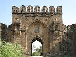
Rohtas Fort
Rohtas Fort (Qila Rohtas) is a historical garrison fort located near the city of Jhelum. It was built by Raja Todar Mal, under the orders of the Afghan king Sher Shah Suri, to subdue the rebellious tribes of the northern Punjab region, in the 16th century. This fort is about 4 km in circumference. The Rohtas fort was built to crush the local Gakhar tribes of Potohar, who rebelled against the Sur dynasty after the Mughal emperor Humayun was ousted by the former.
It took eight years to build the fort, it was captured by Mughal emperor Humayun in 1555.[26] Nader Shah, the Turkic ruler of Persia, Afghan ruler Ahmed Shah Abdali and the Maratha army also camped here during their respective campaigns in the Punjab region. Rohtas was also occasionally used for administrative purposes by the Sikh ruler Ranjit Singh after he captured it in 1825.[27][28]
Agriculture
Jhelum District has a total area of 858,767 acres (3,475.31 km2), out of which 316,815 acres (1,282.10 km2) are cultivated. The area is located on the eastern part of Potohar upland along with River Jhelum.
Agriculture in the District Jhelum depends mainly on rainfall. The average rainfall of the area varies from 20 to 40 inches (1,000 mm). About three fourth of this precipitation is received in monsoon season and the remaining one fourth is received during the rest of the year. The irrigated area at present is limited but the emphasis on construction of small dams is gradually increasing. Wheat remains the main crop.
In Tehsil P.D. Khan, salt is the predominant feature which is spoiling the rich agricultural land day by day. There is a long strip of very rich and virgin soil along the river which could be made a paradise of citrus plantation by drip irrigation if the local people are motivated and the Government of Punjab expressed some interest in it.
Sports


The main sports of the area are centred on agricultural pursuits and excellence and include Bugdar (stone) lifting by young men. A localised version of Kabbadi, bull races centered on a Persian water wheel at the villages of Kantrili, Nathwala and Jada near the suburban town of Kala Gujran. Tent pegging also known as Neza Bazi which indicates the region's prowess during war and battle and hence the city being attributed the name of land of martyrs and warriors. Zamir Jaffri Cricket Stadium near Suleiman Park is named after Zamir Jafri, a prominent poet from Jhelum. Hockey is another sport which is very popular in Jhelum.
Flora and fauna
Vegetation of the forests of Jhelum Forest Division is dry, deciduous shrub type, phulai, kahu (wild olive) and sanatha are the main species. The stocking on the whole is poor and the forests are open. Vegetation is poor on sandstone and red marl. The southern slopes are often devoid of vegetation while north western slopes carry good forests. The forests of Jhelum Forests Division are burdened with right of grazing, browsing and firewood. Under settlement out of total area 93,566 acres (378.65 km2) only 5,468 acres (22.13 km2) about (45%) are right free. Remaining 55% are open to grazing.
The fauna of the District is mostly indigenous restricted, like the vegetation, but similarly varied and interesting. The rugged and rough terrain, low rainfall, the scantly cover of vegetation and the burning passions of the increasing number of hunters, all have their share in limiting the animal kingdom in the District. The river offers a better environment than elsewhere though the hills support a more interesting wildlife. Urial (an animal from deer family) and chinckara are spot aids while wild bores are found in the Salt Range. Wolves, foxes and wild cats are also found. Hare is fairly common. Chikor grey and black Partridge are also found in the parts of the district. Migratory ducks like Teal Pin tail and mallard and some geese visit during winter.
Climate
The climate of the tract is extreme. In winter it is very cold and summer is very hot. The average rainfall varies from 48 to 69 m.m per annum which is much below the required quantity but in the rainy season the water torrents flow from north to the river Jhelum with a very fast speed and cause damages to the crops, bridges, roads and are responsible for the soil erosion in the District.
Over the years, global climate change has affected Jhelum as well as any other place on Earth and below comparison charts from Weatherbase show the difference in climate between 2008 and 2015:
| Climate data for Jhelum, Pakistan | |||||||||||||
|---|---|---|---|---|---|---|---|---|---|---|---|---|---|
| Month | Jan | Feb | Mar | Apr | May | Jun | Jul | Aug | Sep | Oct | Nov | Dec | Year |
| Average high °C (°F) | 20 (68) |
22 (72) |
27 (81) |
33 (91) |
38 (100) |
40 (104) |
36 (97) |
34 (93) |
35 (95) |
33 (91) |
28 (82) |
21 (70) |
31 (87) |
| Average low °C (°F) | 5 (41) |
8 (46) |
12 (54) |
18 (64) |
22 (72) |
26 (79) |
26 (79) |
25 (77) |
23 (73) |
17 (63) |
10 (50) |
6 (43) |
16 (62) |
| Average precipitation mm (inches) | 34 (1.3) |
50 (2) |
60 (2.4) |
36 (1.4) |
32 (1) |
52 (2) |
237 (9.3) |
221 (8.7) |
78 (3.1) |
12 (0.5) |
10 (0.4) |
30 (1.2) |
85.2 (32.2) |
| Source: Weatherbase 2008[29] | |||||||||||||
| Climate data for Jhelum, Pakistan | |||||||||||||
|---|---|---|---|---|---|---|---|---|---|---|---|---|---|
| Month | Jan | Feb | Mar | Apr | May | Jun | Jul | Aug | Sep | Oct | Nov | Dec | Year |
| Average high °C (°F) | 19 (66) |
21 (69) |
27 (80) |
33 (91) |
38 (100) |
40 (104) |
36 (96) |
34 (93) |
34 (93) |
33 (91) |
27 (80) |
21 (69) |
30 (86) |
| Average low °C (°F) | 4 (39) |
7 (44) |
12 (53) |
17 (62) |
22 (71) |
26 (78) |
26 (78) |
25 (77) |
23 (73) |
16 (60) |
9 (48) |
5 (41) |
16 (60) |
| Average precipitation mm (inches) | 35 (1.4) |
46 (1.8) |
45 (1.8) |
32 (1.2) |
27 (1) |
51 (2) |
223 (8.8) |
225 (8.9) |
79 (3.1) |
18 (0.7) |
12 (0.5) |
25 (1) |
81.8 (32.2) |
| Source: Weatherbase 2015[29] | |||||||||||||
Development organizations
Rehmat Welfare Foundation Jhelum is a charity project working for poor and needy people of fifty-mile area including Jhelum which cannot afford the expenses of their daily life and very expensive general medical and kidney dialysis treatment.[30]
Civil Society Human and Institutional Development Program[31] (CHIP)is working in Sohawa Tehsil since 2004, with its field office in the area CHIP has successfully mobilized community people to get organize into Community Based Organizations, Community Citizen Boards and Women Organizations. Further, CHIP has duly built the capacity of these local entities to take new initiatives. These community level organizations, in collaborative partnerships with CHIP, are working on several development projects. The main focus of these projects is to eliminate illiteracy from villages of Sohawa especially those where government education structure does not exist, make clean drinking water available, provide technical support to the local farmers, raise skill development opportunities for women and sensitize communities to include women in decision making. The local community level organizations developed by CHIP are making successful efforts in implementing development projects by deriving funds from local government bodies.
CHIP has announced Sohawa as its main development area and the organization is assessing further development interventions in villages of Sohawa, presently the main focus of organization is to introduce an 'Inclusive Development Model' which suggest active involvement of people with disabilities in the development process.
Education Welfare Society (EWS), a registered NGO, founded in 1995 by Syed Waqar Azeem, a social personality awarded by FAKHR-E-JHELUM (Pride of Jhelum) in 1998 demonstrated role in educational development in the city and represented Jhelum on international level and its educational welfare and developments' needs on major platforms and devoted himself for the welfare of the masses.
Tameer-e-Millat Foundation (TMF), a registered not-for-profit organization, is a development foundation in the district. It is focused on the 100% literate P.D. Khan Initiative. TMF started its first school in 1987 in Khewra a town of P.D. Khan Tehsil. Now, TMF is running ten model schools, fifty community schools, two vocational centers, two computer training centers and an institute of Technology in P.D.Khan Tehsil. Around five thousand boys and girls are studying in TMFs educational network in P.D.Khan. TMF has its model or community school in every union council of P.D. Khan.
Universities, Colleges and Schools
- Punjab University Campus
- Govt. Post Graduate College, Jhelum
- Govt. College. G.T. Road, Jhelum
- Govt. College for Women, Jhelum
- Govt. College of Commerce, Bilal Town, Jhelum
- Govt Girls College, Jalalpur Sharif
- Govt College of Education, Jhelum
- International Islamic University Islamabad Schools, Jhelum
- Lyceumhouse School System Karimpur Road, Jhelum.
- Air Foundation School System, Jhelum (Boys & Girls)
- Air Foundation School System Junior Branch (Near Al-Bilal Hotel)
- Army Public School and College, Jhelum Cantt.
- Farabi Foundation High School for Boys Dina Jhelum.
- Farabi Foundation High School for Girls Dina Jhelum.
- Farabi Foundation Elementary School for Boys Mangla Road Dina Jhelum.
- Farabi Foundation Elementary School for Girls Kalwantpur Dina Jhelum.
- FG Intermediate College Jhelum Cantt.
- Fauji Foundation Model School & College, Jhelum Cantt.
- Cantonment Board CMB Model, Jhelum
- World Over School and College Academy, Jhelum[32]
- Etekosoft Institute of Computer Sciences, Jhelum
- Global College of English Language, Bilal Town Jhelum
- Govt. Noor Mudrassa Tul Banat Girls School, established since 1944
- Government Degree College, Jhelum
- Fahad College
- Govt. Degree College, Sohawa
- Govt. Degree College, Dina
- Govt Model High School, Bair Faqiran
- Army Public School and College, Mangla Cantt
- Research Girls College, Kala Gujran
- Jinnah College of Commerce & Computer Science, Jhelum
- Presentation Convent School, Jhelum
- Jhelum Homeopathic Medical College, GT Road, Jada
- Govt. College of Technology, Chak Daulat
- Govt Model High School Madu Kalas
- Govt Model High School Ratwal , Pind Dadan Khan
- Cambridge College, 10-A Civil Lines, Jhelum
- Beaconhouse School System, G T Road, Jhelum
- Federal Govt. College, Mangla Cantt
- Bahria Foundation College, GT Road, Jhelum
- The Educator School, G.T Road, Jada
- Punjab College, G.T Road, Jhelum
- Wings College of Commerce, 4-Civil Lines, Jhelum
- PICS, Bilal town[33]
- Al Islam Sharia College Ketchehry Road Jhelum[34]
- Govt. Institute of Commerce (W), Sohawa
- Govt. Institute of Commerce, Pind Dadan Khan
- Jinnah College of Commerce, Dina
- Jinnah Law College, Jhelum
- Govt. Al Bairuni Degree College, Pind Dadan Khan
- VU Jhelum Campus
- AIOU - Jhelum campus
- Fatima Jinnah Post Graduate Girls College, Jhelum Cantt
- Jhelum College of Education, Jhelum
- QMA Jinnah College, PD Khan
- Punjab College, PD Khan
- Litra Vally Girls College, Jango
- Bukhari College of Science and Comm Jhelum
- Superior College, Jhelum
- Fauji Foundation Degree College, PD Khan
- GES Kantrila, Jhelum
- Govt. Degree College for Women, Sanghoi
Notable people
- Ghazanfar Ali Khan, Pakistan Movement leader
- Zamir Jafri, poet
- Gulzar, Indian filmmaker, lyricist and poet
See also
- Rawalpindi Division
- Chakwal District
- Attock District
- Pind Dadan Khan Tehsil
- Sohawa Tehsil
- Dina Tehsil
- Jhelum Tehsil
- Kala Gujran
- Gharmala
- Dhanyala
- Noor Pur Baghan
- Muftian
- Raiya Chak Maddu
- Shamaspur
- Tilla Satellite Launch Center
- Kantrila
- Chak Jamal
- Chak Khasa
- Bair Faqiran
- Dhok Masyal
References
- 1 2 Stephen P. Cohen (2004). The Idea of Pakistan. Brookings Institution Press. p. 202. ISBN 0815797613.
- ↑ "Jhelum Report". Crprid.org. Retrieved 2013-01-25.
- ↑ "Urban Resource Centre". urckarachi.org. Retrieved 27 November 2015.
- 1 2 Population of Jhelum District
- ↑ "BBC NEWS - South Asia - Rise of Pakistan's 'quiet man'". bbc.co.uk. Retrieved 27 November 2015.
- ↑ Jhelum District Overview - Punjab Police
- ↑ Administrative Units of Pakistan Archived December 30, 2010, at the Wayback Machine.
- ↑ Tehsils & Unions in the District of Jhelum -Government of Pakistan Archived February 9, 2012, at the Wayback Machine.
- ↑ Masica, Colon P. (9 September 1993). The Indo-Aryan Languages. Cambridge University Press. p. 19. ISBN 0521299446.
- ↑ 1998 Census of Pakistan
- ↑ http://www.statpak.gov.pk/depts/fbs/statistics/pslm_prov2006-07/2.14a.pdf Archived November 13, 2010, at the Wayback Machine.
- ↑ Punjab Education Department's annual literacy statistics for 2006 Daily Times
- ↑ Literacy rate figures still not updated - Daily Times
- ↑ Haroon Jamal (June 2007). Income Poverty at District Level: An Application of Small Area Estimation Technique (PDF) (Report). Social Policy and Development Centre. pp. 15–18. Retrieved 28 January 2014.
- ↑ Gazetteer of the Jhelum District, 1904, Part 1 ,Page 129 ,Sang-e-Meel Publications.
- 1 2 3 "Imperial Gazetteer2 of India, Volume 14, page 152 -- Imperial Gazetteer of India -- Digital South Asia Library". uchicago.edu. Retrieved 27 November 2015.
- ↑ Population of Jhelum City
- ↑ O.H.K. Spate; Andrew T.A. Learmonth; B.H. Farmer (13 July 1972). India, Pakistan and Ceylon: The Regions. Methuen Publishing Ltd. p. 502. ISBN 978-0-416-75530-5. Retrieved 3 April 2012.
- ↑ Weller, J. Marvyn. "The Journal of Geology". jstor.org. Chicago Journals. Retrieved 24 February 2015.
- ↑ Stanley J. Lefond (1 January 1969). Handbook of World Salt Resources (1st ed.). Springer. p. 347. ISBN 978-0-306-30315-9. Retrieved 3 April 2012.
- ↑ Camerapix (July 1998). Spectrum Guide to Pakistan. Interlink Books. p. 150. ISBN 978-1-56656-240-9. Retrieved 8 April 2012.
- ↑ Masud ul Hasan (1975). Short encyclopaedia of Pakistan (1st ed.). Ferozsons. p. 118. ASIN B007EU8QHS. Retrieved 8 April 2012.
- ↑ Sarah Nabruq (11 August 2014). Masquerade. AuthorHouse. p. 43. ISBN 9781496988218.
- ↑ Sarina Singh; Lindsay Brown; Lindsay Brown; Rodney Cocks; John Mock (1 May 2008). Lonely Planet Pakistan and the Karakoram Highway (7th ed.). Lonely Planet. p. 138. ISBN 978-1-74104-542-0. Retrieved 3 April 2012.
- ↑ Pennington, Matthew (25 January 2005). "Pakistan salt mined old-fashioned way mine". The Seattle Times. Retrieved 8 April 2012.
- ↑ "A Brief History of Pakistan". google.com. Retrieved 27 November 2015.
- ↑ "Advanced Study in the History of Modern India 1707-1813". google.com. Retrieved 27 November 2015.
- ↑ "Rohtas fort — the treasure of Potohar". The Express Tribune. 18 September 2011. Retrieved 27 November 2015.
- 1 2 "Weatherbase: Historical Weather for Jhelum, Pakistan". Weatherbase. 2008.
- ↑ About Rehmat Foundation. RehmatFoundation. Retrieved on 2013-07-12.
- ↑ "Civil Society Human and Institutional Development Programme". chip-pk.org. Retrieved 27 November 2015.
- ↑ CAD Consultant. "notesboard". notesboard.blogspot.com. Retrieved 27 November 2015.
- ↑ CAD Consultant. "notesboard". notesboard.blogspot.com. Retrieved 27 November 2015.
- ↑ http://notesboard.blogspot.com/2013/11/al-islam-sharia-college-for-women-jhelum.html
External links
- Jhelum News Portal
- Jhelum District Official Portal
- Jhelum Police Website
- TMA Jhelum Website
- Unofficial Jhelum Website

Provincial capital: Lahore | ||
| Bahawalpur | _Districts.svg.png) | |
| Dera Ghazi Khan | ||
| Faisalabad | ||
| Gujranwala | ||
| Lahore | ||
| Multan | ||
| Rawalpindi | ||
| Sargodha | ||
| Sahiwal | ||
| Sheikhupura | ||
See also: Districts of Punjab, India | ||
Coordinates: 32°56′N 73°44′E / 32.933°N 73.733°E