Sarai Alamgir
| Sarai Alamgir | |
|---|---|
|
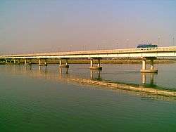
The River Jhelum and the bridge from Sarai Alamgir side | |
 Sarai Alamgir Location in Pakistan | |
| Coordinates: 32°54′N 73°45′E / 32.900°N 73.750°ECoordinates: 32°54′N 73°45′E / 32.900°N 73.750°E | |
| Country | Pakistan |
| Region | Punjab |
| District | Gujrat District |
| Towns | 4 |
| Union councils | 7 |
| Population | |
| • Total | 350, 288 (estimated as per March 2,016). |
| Time zone | PST (UTC+5) |
| • Summer (DST) | PDT (UTC+6) |
| Website | http://www.tmasaraialamgir.com/ |
Sarai Alamgir (Punjabi, Urdu: سرائے عالمگیر) (pop. 175,288 (as per Government of Punjab figures from 1998) is the main town of Sarai Alamgir Tehsil, located in the Gujrat district in the north of the Punjab province of Pakistan. Sarai Alamgir is one of three tehsils of Gujarat.[1]
Sarai Alamgir covers 575 km2 (222 sq mi) on the eastern bank of the Jhelum River, across from the larger town of Jhelum. East of the town is the Upper Jhelum Canal. Sarai Alamgir was raised to the level of Municipal Committee in 1976. After the implementation of Punjab Local Government Ordinance 2001, it was given the status of Tehsil Municipal Administration (TMA).[1]
Geography and climate
Sarai Alamgir is located at 32°54′00″N 73°45′00″E / 32.90000°N 73.75000°E (32.900000, 73.750000); it lies at 232 m (761 ft) above sea level. The district has a moderate climate. During the summer, temperatures can reach 45 °C (113 °F) for short periods. Winter months are mild, temperatures rarely falling below 2 °C (36 °F). Sarai Alamgir is located south of Jhelum City, which lies across the Jhelum River. To the west of Sarai are the cities Mirpure and Bhimber. Mandi Bahauddin and Rasul are located to the east of Sarai Alamgir.[2]
History
In ancient history, the region participated in the Indus Valley Civilization and the Gandhara civilization. At a later date, the Battle of the Hydaspes took place nearby, between the armies of Alexander the Great and the Great King Porus.[3] In the past, people of influence would build a sarai, which would be caravan stations and rest houses for travelers. A typical sarai would consist of a drinking well, a praying area and a resting place for people.
The 'sarai' (rest area) at Sarai Alamgir was discovered by the Mughal emperor Aurangzeb because of its strategic location on the Grand Trunk Road and the Jhelum River, and its proximity to Kashmir. Over time, Sarai Alamgir developed into a central town for adjoining village populations.
Sarai Alamgir gained prominence when the King George V Royal Indian Military School was established on March 3, 1922; it was one of four such cadet schools in British India to benefit the sons of members of the Royal Indian Army. The college is now known as the Military College Jhelum and is one of the oldest institutions in Pakistan.[4]
Administration
The Tehsil Municipal Administration is a corporate body and consists of the Tehsil Nazim, Tehsil Municipal Officer, four Tehsil Officers and other officials of the Local Council Service, and officials of the offices entrusted to the Tehsil Municipal Administration. A Tehsil Nazim is the head of Tehsil Municipal Administration and exercises all functions and powers assigned to him under the Ordinance. The Tehsil Municipal Officer acts as coordinating and administrative officer, in charge of the Tehsil Officers.[5]
Surrounding important places
Sarai Alamgir is a historic crossroads between the ancient Grand Trunk Road and the Jhelum River. Nearby are the sites of the Battle of the Hydaspes, the historic and ancient Alexandrian city of Bukephala (or Bucephala) and the huge Rohtas Fort.[3][6]
Boundaries
Sarai Alamgir city has these cities in its surrounding areas:
West
East
North
South
Notable People
- Chaudhry Muhammed Farooq, politician
Union councils
Sarai Alamgir Tehsil consists of nine union councils that, along with their respective populations in 1998, are:
- Mandi Bhalwal (109): 18,960
- Bhagnagar (113): 17,282
- Karyala (113): 20,531
- Simbli Rajgan(114): 21,936
- Khohar (115): 32,486
- Sarai Alamgir-I (116): 17,271
- Sarai Alamgir-II (117): 19,895
- Thill Bakohal (110): 18,574
- Baisa (111): 20,353
- Total 175,287 (As per Government of Punjab figures from 1998)[1]
Communication
The nearest international airports are at Islamabad and Sialkot, about 127 km (79 mi) and 90 km (56 mi) away, respectively.[7] There are other transport links to the town, including a railway station, the Grand Trunk Road, the Jhelum River and the Upper Jhelum Canal. Sarai Alamgir is located on GT Road (N5) and Pakistan's main railway line. A highway connects it with Mandi Bahauddin, while the other one goes to Mirpur, Azad Kashmir.
Villages of Tehsil Sarai Alamgir
The major villages of Tehsil Sarai Alamgir are:
- Mandial
- KAKROT
- Sheikhpur (Androoni)
- Dhera
- Chakhrayl
- Pail
- Mehra
- Gurah Nehala
- Phagli
- Nali
- Tangri
- Chotha Thala
- Barah Thala
- Gunni
- Chotha Sang
- Sang Numberdarah
- Suker
- Chariah
- Gurah Habib
- Lendah
- Nadenah
- Chak Qaim
- Maira Pothi
- Dakjattan
- Moja Shareef
- Gurrah Burj
- Mandi Bhalwal
- Pindijattan
- Bhumbla
- Aurangabad
- Pahirwal (Patan Wala)
- Khadriala
- Kharka
- Simbli
- Khohar
- Khambi
- Khanpur Khamb
- Fatehpur
- Dhall
- Puran
- Gurrah Jattan
- Bhalwal Gharbi
- Bhowanj
- Qasba Karyali
- Bhag Nagar
- Nukhian
- Mumazpur
- Rasheed Pur
- Kalas
- Pindi Ajutas
- Khal
- Baisa Kalan (Baisa Rajgan)
- Masoom Pur
- Shakreela Shareef
- Gorian
- Hattar
- Jaggu Head
- Jaggu
- Kinara Lass
- Dandi Nazam
- Dandi Bazar
- Nakka Bhagali
- Choa Rajgan
- Phullarwan
- Bulani
- Pirkhana Jattian
- Pirkhana Rajgan
- Rajr Kalan
- Bawali
- Karyala
- Gaddi Gurrah
- Meh Kalan
- Nai Abadi
- Kotha Karyala
- Gial Bala
- Gial Zer Nothia-Qureshian
- Balobanian
- Qazi Baqar
- Thoon
- Majeed Abad
- Rasib Colony
- Father Colony
- Bijli Ghar
- Naryal
- Khambi Mara
- Paharian Na Dera
- Kund
- Chowa Mara.
- Kastila
- Dhoke Mureed
- Kanyal
- Anwar Pur (muri)
- Mandi jattan
- Mahay Khurd
- Mahay kalan
- Chak Natha
- Khanpoor
- khambi
- Simbli
- pooran
- Narwal
- Bharwal
- Marlan
- Chapran
- Kotian
References
- 1 2 3 http://tmasaraialamgir.com/History.html, Tehsil Municipal Administration (TMA) Sarai Alamgir town, District Gujrat, Punjab, Pakistan, Published in 2007, Retrieved 3 Aug 2016
- ↑ http://www.maplandia.com/pakistan/punjab/jhelum/sarai-alamgir/, Detailed satellite map of Sarai Alamgir and its nearby places, Retrieved 3 Aug 2016
- 1 2 http://www.livius.org/articles/battle/hydaspes/?, Battle between Alexander the Great and Porus near Sarai Alamgir and Jhelum area on livius.org website, Retrieved 4 Aug 2016
- ↑ http://militarycollege.edu.pk/new/, Military College, Jhelum website, Retrieved 9 Aug 2016
- ↑ http://tmasaraialamgir.com/Administrative-Setup.html, Administrative setup of Tehsil Sarai Alamgir, Retrieved 9 Aug 2016
- ↑ http://nation.com.pk/islamabad/03-Jun-2013/renovated-rohtas-fort-to-boost-tourism, Rohtas Fort article on The Nation newspaper, Published 3 June 2013, Retrieved 4 Aug 2016
- ↑ http://www.islamabadairport.com.pk/, Islamabad International Airport, official website, Retrieved 9 Aug 2016