Jesús María District, Lima
| Jesús María Jesus María Mi Barrio | ||
|---|---|---|
| District | ||
|
City hall | ||
| ||
 Location of Jesús María in the Lima province | ||
| Country |
| |
| Region | Lima | |
| Province | Lima | |
| Founded | December 17, 1963 | |
| Government | ||
| • Mayor | Carlos Bringas Claeyssen | |
| Area | ||
| • Total | 4.57 km2 (1.76 sq mi) | |
| Population (2007 est.) | ||
| • Total | 66,171 | |
| • Density | 14,000/km2 (38,000/sq mi) | |
| Time zone | PET (UTC-5) | |
| UBIGEO | 150113 | |
| Website | munijesusmaria.gob.pe | |

Jesús María (Lima 11) is one of the most centrally located districts of Lima, Peru. It is a lower-middle to upper-middle class, high density district and it usually ranks in the top four districts with the best quality of life in Lima with an HDI of 0.770 (2005), only behind the districts of San Isidro and Miraflores.
Jesús María is located 103 meters above sea level and bordered by the districts of Pueblo Libre and Breña District on the west, downtown Lima on the north and east, Lince District on the east, and San Isidro and Magdalena del Mar on the south. Until 1963, when it was made into a separate district, Jesús María was attached to Lima District.
History
In the pre-Conquest period, the area that is now Jesús María was part of the Curacazgo of Guatca. The lower end of the Rimac valley was divided among several districts ruled by a lord (curaca), each charged with administering the lands and water along a pre-Inca irrigation network. The Curacazgo of Guatca followed the course of the canal known as the Huatica river.[1] After passing through what is today La Victoria, the Huatica's main subsidiary canal coursed down what is today Salaverry Avenue in Jesús María[2] and, ultimately, reached the sea at Marbella in Magdalena del Mar district.[3]
In the Spanish colonial period the area's lands were transferred to Spanish and criollo landlords, becoming haciendas, such as Jesús María, Matalechuza, and Matalechucitas.[2][4] In the 20th Century, as urbanization spread the area was made part of the district of Lima.
In 1930 its inhabitants decided to formally organize themselves into the Jesús María neighborhood association. The following year they established the Pro-Jesús María District Civic Commission, with Mr. Enrique Mafuelo Caceres presiding.[5]
On December 27, 1955, Congress approved Law 14763, establishing the District of Jesús María, but it was not put into effect. Eight years later, on December 17, 1963, President Fernando Belaúnde Terry ratified the law and Jesús María District officially came into existence,[6] although it did not have its own administration until the elections of November 1966, when José Benavides Muñoz was elected its first mayor.[5]
Jesús María Today
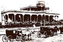
Today, Jesús María is a lower-middle to upper-middle class, highly residential district, home to 66,000 people. The district usually ranks in the top four districts with the best quality of life in Lima.[7] The district's central location and proximity to San Isidro and Miraflores, have also contributed to it becoming an increasingly popular residential option.[7] Jesús María is experiencing a housing and construction boom, and many casonas (older large, luxury homes) are being replaced with high-rise apartments and condominiums. Some of the best preserved are those that have been adapted as businesses or government installations, such as the Jesús María City Hall.
Between Salaverry and Gregorio Escobedo avenues can be found the Residencial San Felipe on the site of what was once the San Felipe horse track. Commissioned by President Fernando Belaúnde Terry, and designed by a team headed in part by architects Enrique Ciriani, Jorge Páez, Jorge Bernuy, and Nikita Smirnoff Bracamonte, San Felipe was designed to combine a high residential density with ample green space, and shopping, banking, and schooling[8] opportunities for residents,[9][10] and is widely considered the cornerstone of Jesús María's middle-class identity.[11][12][13]
Commercial activity in Jesús María has historically centered on the area surrounding the Plaza San José and the nearby old San José market, and on the commercial sector contained within the Residencial San Felipe. To this, there has been added the Real Plaza Salaverry shopping mall, opened in May 2014, on the 23rd block of Avenida Salaverry, on land that held the last remnants of the old San Felipe race track.
Landmarks
Main avenues in Jesús María are Salaverry, Mariategui, and San Felipe. Other important avenues which demarcate the boundaries of the district are Javier Prado Oeste, Brasil, and 28 de Julio.
San José Park -which serves a de facto main square for the district- marks the district's original "downtown". Its San José Church, with its twin neo-Gothic spires, has been a landmark of the district since its inauguration by the Carmelite Order in 1949.[14]
One of the largest parks in the city of Lima, El Campo de Marte, is located in Jesús María. It contains a monument to the War of 1942 fought between Peru and Ecuador, the monument to a century of Japanese immigration, and the Eye that Cries, commemorating those killed and disappeared during Peru's internal conflict between 1980 and 1992. It is also home to the district's municipal sports complex.
The Universidad del Pacífico, one of the most prestigious universities in the country, is located in Jesús María, on Avenida Salaverry. Several renowned research institutions also have their offices in Jesus Maria, including the Instituto de Estudios Peruanos (IEP), the Equipo Peruano de Antropologia Forense (EPAF), and the Centro Peruano de Estudios Sociales (CEPES).
The district is also home to San Marcos University's Museum of Natural History, which was established in 1918 and houses important Peruvian fossils and the specimen collection of early Peruvian geographer and explorer, Antonio Raimondi.
Nearby, are the Ministry of Labor and Ministry of Health, as well as the Edgardo Rebagliati Martins Hospital, one of the largest and busiest health centers in the country.
Climate
Summer (January–April), high 26 to 30°C, low 20 to 23°C, sunny days with cloudy nights and early mornings.
Winter (June–November) high 18 to 20°C, low 14 to 16°C, usually overcast with frequent fog.
Humidity: 60% to 70% summer afternoons, 90% to 100% in winter and at night.
Gallery
 Eastern entrance to Jesús María at the intersections of "Avenida de la Peruanidad" and "Avenida Salaverry", with the monument to Jorge Chávez.
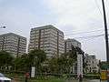 Western entrance to Jesús María in front of "Residencial San Felipe," a middle-class housing complex.
 "Iglesia San José" in front of the "Parque San José" in Jesús María.
 Cultural center ("Centro Cultural") in Jesús María on "Avenida Horacio Urteaga."
 Typical street in Jesús María, Monitor Huascar, as seen from Arnaldo Marquez.
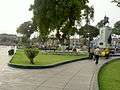 One of Jesús María's many plazas, the Parque Cáceres.
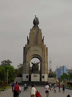
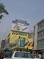 Metro Supermarket, and a cinemaplex on the highly commercial "Avenida Garzón" in Jesús María.
External links
- (Spanish) Municipalidad de Jesús María - Jesús María district council official website
References
- ↑ Agurto Calvo, Santiago. Lima prehispánica (1984). On-line edition, Universidad Nacional Mayor de San Marcos, 2007. (Entry retrieved 5 May 2012.)
- 1 2 A la vuelta de la esquina TV show, episode on the Río Huatica. Air date unknown. Available online (Retrieved 5 may 2012)
- ↑ "El río Huatica" at Suqanqa blog, posted 6 July 2009. (Retrieved 5 May 2012.)
- ↑ "El distrito de Jesus Maria", Rumbo al Bicentenario: Historia del Peru, America Latina y el mundo website. (Entry retrieved 18 August 2013)
- 1 2 Municipalidad de Jesús María (2012), "Tu distrito". Online, posted 12 September 2012. (Retrieved 4 April 2013)
- ↑ Municipalidad de Jesús María (2010), Plan de desarrollo concertado, ajustado al 2015. Resumén ejécutivo.
- 1 2 "The District of Jesus Maria", at Expat Peru website. (Entry accessed 6 June 2014)
- ↑ See entry for San Felipe Cooperative School
- ↑ Interview with architect Enrique Ciriani, "Entrevista a Enrique Ciriani sobre la Residencial San Felipe. Perú 21." in Bitacora|arquitectura peruana blog, 17 June 2009. (Entry retrieved 22 May 2012)
- ↑ Conjunto Residencial San Felipe in Divagaciones y Arquitectura blog, 16 May 2012 (Entry retrieved 22 May 2012)
- ↑ Pereyra, Omar. Contemporary Middle Class in Latin America: A study of San Felipe. Lexington Books, 2015. ISBN 978-0-7391-9106-4.
- ↑ Sinesio López Jímenez, "El Zorro de Abajo. Residencial San Felipe" in La República, 14 March 2008. Available online.
- ↑ Rafo León, "Megabarbaridad en Jesús María" in SOMOS magazine, March 2008.
- ↑ Parroquia San José, at website of the Order of the Discalced Carmelites in Peru. (Entry retrieved 6 June 2014)
Coordinates: 12°04′42″S 77°02′53″W / 12.07833°S 77.04806°W