Jargalant, Khövsgöl
| Jargalant District Жаргалант сум ᠵᠢᠷᠭᠠᠯᠠᠩᠲᠤᠰᠤᠮᠤ | |
|---|---|
| District | |
|
In the sum center | |
| Country | Mongolia |
| Province | Khövsgöl Province |
| Time zone | UTC + 8 (UTC+8) |


Jargalant (Mongolian: Жаргалант, lit. "happiness") is a sum of Khövsgöl aimag. The area is about 2,550 km², of which 1,470 km² are pasture. In 2000, the sum had 5068 inhabitants, mainly Khalkha. The center, officially named Orgil (Mongolian: Оргил), is situated close to the Ider river, 182 km south-southeast of Mörön and 886 kilometers from Ulaanbaatar.
History
The Jargalant sum was founded, as part of Arkhangai and under the name Ikh Jargalant, in 1931. In 1933, it had about 2,700 inhabitants in 727 households, and about 66,000 heads of livestock. In 1941 it became part of Khövsgöl aimag. In 1956, it was united with Shine-Ider sum, but became separated again in 1959. In 1973, the Büren and Bürenkhaan sums were joined to Bürentogtokh sum. The local negdel, named Ulaan Tug, was founded in 1951.
Economy
In 2004, there were roughly 82,000 heads of livestock, among them 37,000 sheep, 34,000 goats, 6,100 cattle and yaks, 5,100 horses, and 19 camels.[1]
Miscellaneous
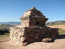
The sum features one of the very few surviving pre-1990 lamaist structures of the aimag, Jargalantyn Dugan (temple) dating from 1890. Gelenkhüü's suvarga is located 20 km north of the sum center. It was built in 1890 and has been renovated several times.[2] Both Gelenkhüü and Öndör Gongor hail from Jargalant. The museum displaying various religious items, stuffed animals and old photos is worth a visit as well.
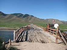
There is a sightworthy wooden bridge near Jargalant which was built in 1940. A new bridge is just (2011) under construction.
There are three hotels in and around Jargalant Town.
Literature
M.Nyamaa, Khövsgöl aimgiin lavlakh toli, Ulaanbaatar 2001, p. 85f
References
- ↑ National Statistical Office: Livestock count 2004 (in Mongolian), p.111
- ↑ Michael Kohn: Mongolia, p.163. London 2008
| Wikimedia Commons has media related to Jargalant, Khövsgöl. |
Coordinates: 48°35′N 99°21′E / 48.583°N 99.350°E