Jackson Township, Brown County, Ohio
| Jackson Township, Brown County, Ohio | |
|---|---|
| Township | |
|
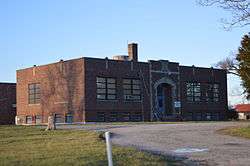
Community center on U.S. Route 62 at Ash Ridge | |
 Location of Jackson Township in Brown County | |
| Coordinates: 38°55′18″N 83°45′24″W / 38.92167°N 83.75667°WCoordinates: 38°55′18″N 83°45′24″W / 38.92167°N 83.75667°W | |
| Country | United States |
| State | Ohio |
| County | Brown |
| Area | |
| • Total | 28.3 sq mi (73.4 km2) |
| • Land | 28.2 sq mi (73.0 km2) |
| • Water | 0.2 sq mi (0.4 km2) |
| Elevation[1] | 997 ft (304 m) |
| Population (2010) | |
| • Total | 1,581 |
| • Density | 56/sq mi (21.7/km2) |
| Time zone | Eastern (EST) (UTC-5) |
| • Summer (DST) | EDT (UTC-4) |
| FIPS code | 39-37688[2] |
| GNIS feature ID | 1085798[1] |
Jackson Township is one of the sixteen townships of Brown County, Ohio, United States. The 2010 census found 1,581 people in the township.[3]
Geography
Located in the eastern part of the county, it borders the following townships:
- Eagle Township - north
- Winchester Township, Adams County - northeast
- Wayne Township, Adams County - southeast
- Byrd Township - south
- Jefferson Township - southwest
- Franklin Township - west
- Washington Township - northwest corner
No municipalities are located in Jackson Township.
Name and history
It is one of thirty-seven Jackson Townships statewide.[4]
Jackson Township was established in 1823.[5]
Government
The township is governed by a three-member board of trustees, who are elected in November of odd-numbered years to a four-year term beginning on the following January 1. Two are elected in the year after the presidential election and one is elected in the year before it. There is also an elected township fiscal officer,[6] who serves a four-year term beginning on April 1 of the year after the election, which is held in November of the year before the presidential election. Vacancies in the fiscal officership or on the board of trustees are filled by the remaining trustees.
References
- 1 2 "US Board on Geographic Names". United States Geological Survey. 2007-10-25. Retrieved 2008-01-31.
- ↑ "American FactFinder". United States Census Bureau. Archived from the original on September 11, 2013. Retrieved 2008-01-31.
- ↑ "Geographic Identifiers: 2010 Demographic Profile Data (G001): Jackson township, Brown County, Ohio". U.S. Census Bureau, American Factfinder. Retrieved February 20, 2014.
- ↑ "Detailed map of Ohio" (PDF). United States Census Bureau. 2000. Retrieved 2007-02-16.
- ↑ The History of Brown County, Ohio. Higginson Book Company. 1883. p. 655.
- ↑ §503.24, §505.01, and §507.01 of the Ohio Revised Code. Accessed 4/30/2009.
External links
Municipalities and communities of Brown County, Ohio, United States | ||
|---|---|---|
| Villages | 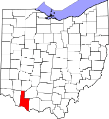 | |
| Townships | ||
| CDPs | ||
| Unincorporated communities | ||
| Footnotes | ‡This populated place also has portions in an adjacent county or counties | |