Itapema
| Itapema | |||
|---|---|---|---|
|
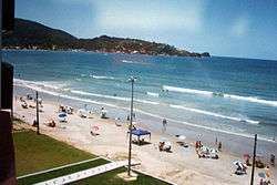
one of Itapema's beaches | |||
| |||
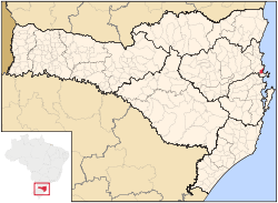 Location of Itapema | |||
 Itapema Location of Itapema | |||
| Coordinates: 27°05′24″S 48°36′39″W / 27.09000°S 48.61083°WCoordinates: 27°05′24″S 48°36′39″W / 27.09000°S 48.61083°W | |||
| Country |
| ||
| Region | South | ||
| State |
| ||
| Founded | April 21, 1962 | ||
| Government | |||
| • Mayor | Rodrigo Costa "Bolinha" (PSDB) | ||
| Area | |||
| • Total | 59.022 km2 (22.789 sq mi) | ||
| Elevation | 2 m (7 ft) | ||
| Population (2010) | |||
| • Total | 45,814 | ||
| • Density | 776,22/km2 (201,040/sq mi) | ||
| Time zone | UTC-3 (UTC-3) | ||
| • Summer (DST) | UTC-2 (UTC-2) | ||
| HDI (2000) | 0.796 | ||
| Website | www.itapema.sc.gov.br | ||

Itapema is a city in Santa Catarina, Brazil.
Geography
Itapema can be accessed from highway BR-101 and it is surrounded by a rocky coastline.
Buildings
Five hundred thousand square meters of civil construction projects were built in Itapema between 2003 and 2005.
Tourism
Itapema is the third most popular tourist destination in Santa Catarina. The beaches are the biggest tourist attraction and the Meia Praia, or Middle Beach of Itapema is the longest.
| |
| Blumenau | |
| Itajaí | |
| Ituporanga | |
| Rio do Sul | |
This article is issued from Wikipedia - version of the 5/15/2016. The text is available under the Creative Commons Attribution/Share Alike but additional terms may apply for the media files.