Iowa Highway 70
| ||||
|---|---|---|---|---|
 | ||||
| Route information | ||||
| Maintained by Iowa DOT | ||||
| Length: | 23.954 mi[1] (38.550 km) | |||
| Existed: | 1969[2] – present | |||
| Major junctions | ||||
| South end: |
| |||
|
| ||||
| North end: |
| |||
| Location | ||||
| Counties: | ||||
| Highway system | ||||
| ||||

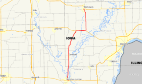
Iowa Highway 70 (Iowa 70) is a state highway spanning 24 miles (39 km) from north to south in eastern Iowa. It begins at Iowa Highway 92 in Columbus Junction, and ends at U.S. Highway 6 in West Liberty.
Route description
Iowa Highway 70 begins less than 1 mile (1.6 km) from the confluence of the Iowa River and the Cedar River near Columbus Junction. It bypasses Columbus Junction to the north and east, then straightens out and crosses the Iowa River. As the Iowa River meanders away, the highway passes riverfront houses on the banks of the Cedar River. The Cedar also meanders away and Iowa 70 enters Conesville.[3] It continues north towards Nichols, following an abandoned Burlington, Cedar Rapids and Northern Railway line.[4] At Nichols, Iowa 70 intersects Iowa Highway 22 and the two highways overlap for 3 miles (4.8 km). From the split with Iowa 22, Iowa 70 heads north towards West Liberty. Iowa 70 ends at an intersection with U.S. Route 6 in West Liberty.[1]
History
Iowa Highway 70 was created in 1969. It replaced the former Iowa Highway 76 as that number was reassigned to a highway in northeastern Iowa.[5] The original route ran from Columbus City to West Liberty. In the mid-1990s, a short bypass was built around Columbus Junction.[6] Iowa 70 traffic was rerouted onto the bypass where it ends today. The old segment stayed remained in the primary highway system until July 1, 2003, when it was turned over to Louisa County.[7]
Major intersections
| County | Location | mi[2] | km | Destinations | Notes |
|---|---|---|---|---|---|
| Louisa | Columbus Junction | 0.000 | 0.000 | ||
| Muscatine | Nichols | 14.805 | 23.826 | ||
| Pike Township | 17.692 | 28.473 | |||
| West Liberty | 23.954 | 38.550 | |||
1.000 mi = 1.609 km; 1.000 km = 0.621 mi
| |||||
References
- 1 2 "2009 Volume of Traffic on the Primary Road System of Iowa" (PDF). Iowa Department of Transportation. January 1, 2009. Retrieved September 29, 2010.
- 1 2 "Highway 76 is renumbered". The Muscatine Journal and News-Tribune. December 30, 1969. p. 101. Retrieved May 12, 2016 – via Newspapers.com.

- ↑ Transportation Map (PDF) (Map). Iowa Department of Transportation. 2010. Retrieved September 29, 2010.
- ↑ General Atlas of the World (Map). Rand, McNally & Co. 1898. p. 47.
- ↑ Iowa State Highway Map (PDF) (Map). Iowa State Highway Commission. 1970. Retrieved September 29, 2010.
- ↑ Iowa State Highway Map (PDF) (Map). Iowa Department of Transportation. 1996. Retrieved September 29, 2010.
- ↑ Iowa State Highway Map (PDF) (Map). Iowa Department of Transportation. 2004. Retrieved September 29, 2010.
External links
- End of Iowa 70 at Iowa Highway Ends