Iowa Highway 58
| ||||
|---|---|---|---|---|
 | ||||
| Route information | ||||
| Maintained by Iowa DOT | ||||
| Length: | 12.030 mi[1] (19.360 km) | |||
| Major junctions | ||||
| South end: |
| |||
|
| ||||
| North end: |
| |||
| Location | ||||
| Counties: | Black Hawk | |||
| Highway system | ||||
| ||||

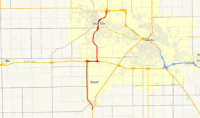
Iowa Highway 58 (Iowa 58) is a state highway that runs from north to south in northeast Iowa. A 5 1⁄2-mile (8.9 km) portion of the highway is overlapped by the Avenue of the Saints. Iowa 58 begins at U.S. Route 63 in Hudson and ends at an interchange with U.S. Route 218 and Iowa Highway 57. Iowa 58's route has changed many times in its history, but has always served Black Hawk County.
Route description
Iowa Highway 58 begins at the intersection of U.S. Route 63, known locally as Sergeant Road, and Hudson Road on the southern edge of Hudson. Iowa 58 passes Hudson High School and turns to the northwest through town. North of Hudson, the highway straightens to the north again and travels 4 miles (6.4 km) to a partial cloverleaf interchange with U.S. Route 20 (US 20). Iowa 58 turns east onto US 20 and shares the roadway for one mile (1.6 km).[1]
Iowa 58 leaves US 20 at exit 255 on the outskirts of Cedar Falls. From the opposite direction, Iowa Highway 27, the Avenue of the Saints highway, also exits US 20 and the two routes head north. For 2 1⁄2 miles (4.0 km), Iowa 27 / Iowa 58 travel on a signal-controlled freeway.[1] This is the only section of the Avenue of the Saints highway in Iowa that is controlled by traffic lights.[2] North of Greenhill Road, the last signal-controlled intersection, Iowa 27 / Iowa 58 share a freeway. One mile (1.6 km) north of the Greenhill Road intersection is an interchange with University Avenue.[1] East of this interchange, University Avenue is designated as Iowa Highway 934, but it is never signed as such.
Iowa 27 / Iowa 58 continue north for 2 miles (3.2 km), crossing the Cedar River near George Wyth State Park, before Iowa 58 ends at a full interchange with U.S. Route 218 and Iowa Highway 57.[1] The US 218 interchange is also the eastern end of Iowa 57. The Avenue of the Saints highway continues north with US 218 towards Waverly.
History
The original Primary Road 58 connected the Jefferson Highway, now U.S. Route 65 west of Eldora to the Red Ball Highway, now U.S. Route 218, east of Dysart. Primary Road 58 followed what is now Iowa Highway 175 to U.S. Route 63 to Iowa Highway 8.[3] By 1952, Iowa 58's eastern half had shifted to the north. Instead of heading south at US 63, it headed north towards Hudson. It headed along Hudson Road and ended at US 20 on the northern edge of Cedar Falls.[4] As a result of the 1969 highway renumbering, Iowa 58 was truncated at US 63 in Hudson.[5] In the 1980s, US 20 was rerouted onto a freeway south of Cedar Falls and Waterloo. By 1989, Iowa 58's north end had been truncated to the new freeway.[6] In the early 1990s, the freeway which Iowa 58 now shares with Iowa 27 was constructed. By 1996, it had been extended and routed onto the new Avenue of the Saints freeway, giving it its current length.[7] The Iowa 27 designation was extended over the entire Avenue of the Saints highway in 2001.
Major intersections
The entire route is in Black Hawk County.
| Location | mi[1] | km | Destinations | Notes | |
|---|---|---|---|---|---|
| Hudson | 0.000 | 0.000 | |||
| Cedar Falls | 5.158 | 8.301 | South end of US 20 overlap | ||
| 6.249 | 10.057 | North end of US 20 overlap and south end of IA 27 overlap | |||
| 9.947 | 16.008 | University Avenue | |||
| 10.648 | 17.136 | Access to Sartori Memorial Hospital | |||
| 12.030 | 19.360 | North end of IA 27 overlap. Northern terminus | |||
1.000 mi = 1.609 km; 1.000 km = 0.621 mi
| |||||
References
- 1 2 3 4 5 6 "2008 Volume of Traffic on the Primary Road System of Iowa" (PDF). Iowa Department of Transportation. January 1, 2008. Retrieved April 6, 2010.
- ↑ Ericson, Jon (October 24, 2004). "DOT says keep Hwy. 58 speed the same". The Courier. Waterloo – Cedar Falls. Retrieved April 6, 2010.
- ↑ Junior Road Map: Eastern Iowa (Map). Rand McNally & Company. 1926. Retrieved April 6, 2010.
- ↑ 1952 Iowa State Highway Map (PDF) (Map). Iowa State Highway Commission. Retrieved April 6, 2010.
- ↑ 1969 Iowa State Highway Map (PDF) (Map). Iowa State Highway Commission. Retrieved April 6, 2010.
- ↑ 1989 Iowa State Highway Map (PDF) (Map). Iowa Department of Transportation. Retrieved April 6, 2010.
- ↑ 1996 Iowa State Highway Map, Waterloo-Cedar Falls inset (PDF) (Map). Iowa Department of Transportation. Retrieved April 6, 2010.