Interstate 115
| ||||
|---|---|---|---|---|
|
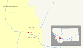
Interstate 115 highlighted in red | ||||
| Route information | ||||
| Maintained by MDOT | ||||
| Length: | 1.194 mi[1] (1.922 km) | |||
| Existed: | 1971 – present | |||
| Major junctions | ||||
| West end: |
| |||
| East end: |
| |||
| Highway system | ||||
| ||||
.svg.png)
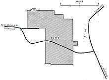
Interstate 115 (I-115) is a short auxiliary Interstate Highway which connects Interstate 15/90 to Butte in the U.S. state of Montana. The highway is 1.19 miles (1.92 km) long and is overlapped by Business Interstate 15/90 for its entire length. The route travels from an incomplete interchange with I-15/90 through generally rural areas in western Butte. It interchanges with Excelsior Avenue before terminating. The entire route was improved to interstate standards during the 1960s, and was improved in 2005.
Route description
Interstate 115 begins at an interchange with Interstate 15 / Interstate 90. As a two-lane highway in both directions, I-115 heads east into downtown Butte. Before reaching exit 1, eastbound traffic makes a curve while westbound traffic goes to Interstate 15/90 without making such a curve, therefore that portion of I-115 contains a large median. Approximately 1 mile (1.6 km) from I-15/I-90, I-115 has its only interchange at Excelsior Avenue, which can be used to access the town of Walkerville. Excelsior Avenue is the only numbered exit along I-115, and the structure of the interchange directs motorists to stop and yield signs, as opposed to traffic signals for most exits in urban areas. I-115 ends at the overpass over Excelsior Avenue. It continues into Butte as I-15 Bus. / I-90 Bus..[2][3]
History
The development of a freeway along the modern-day I-115 corridor was proposed in the 1950s. The 1955 General Location of National System of Interstate Highways, an early platform for what would become the Interstate Highway System, contained an inset of the proposed freeways in and around the city of Butte including an east-west freeway spur on the west side of the community.[4] Designated as part of the Interstate Highway System around 1957, I-115's construction was funded by the federal government.[5][lower-alpha 1]
Exit list
The entire route is in Silver Bow County.
| Location | mi[8] | km | Exit | Destinations | Notes |
|---|---|---|---|---|---|
| | 0.000 | 0.000 | Exit 124 on I-15/I-90; no access to I-15 north/I-90 east | ||
| Butte | 1.194 | 1.922 | 1 | Excelsior Avenue – Walkerville | |
| Continuation beyond Excelsior Ave. | |||||
| 1.000 mi = 1.609 km; 1.000 km = 0.621 mi | |||||
References
Footnotes
- ↑ I-115 was constructed and included in the Interstate Highway System before 1978. The Surface Transportation Assistance Act of 1978 provided that all Interstate construction authorized under previous amendments to the system would be funded by the federal government but additional highway mileage added under 23 U.S.C. § 103(c)(4)(A) would not be supported by the same allocation of funds.[6][7]
References
- ↑ Montana Road Log, p. 1
- ↑ Google (December 20, 2013). "Interstate 115" (Map). Google Maps. Google. Retrieved December 20, 2013.
- ↑ Montana Road Log, p. 22
- ↑ "Butte, Montana" (Map). General Location of National System of Interstate Highways Including All Additional Routes at Urban Areas Designated in September 1955. 1 inch=1 mile. Cartography by BPR. Bureau of Public Roads. September 1955. p. 51. OCLC 4165975.
- ↑ DeSimone, Tony (October 31, 2002). "Table 2: Auxiliary Routes of the Dwight D. Eisenhower National System Of Interstate and Defense Highways as of October 31, 2002". Route Log and Finder List. Federal Highway Administration. OCLC 47914009. Retrieved December 20, 2013.
- ↑ United States Congress (1978). Surface Transportation Assistance Act of 1978. Pub.L. 99–599.
- ↑ DeSimone, Tony (June 4, 2012). "Expansion of Mileage". Route Log and Finder List. Federal Highway Administration. OCLC 47914009. Retrieved December 20, 2013.
- ↑ Staff (2011). Montana Road Log (PDF) (Report) (2011 ed.). Montana Department of Transportation. Retrieved December 21, 2013.
External links
| ||