Indiana State Road 69
| ||||
|---|---|---|---|---|
 | ||||
| Route information | ||||
| Maintained by INDOT | ||||
| Length: | 35.07 mi[1] (56.44 km) | |||
| Existed: | 1931[2][3] – present | |||
| Major junctions | ||||
| South end: |
Hovey Lake Fish and Wildlife Area
| |||
| North end: |
| |||
| Location | ||||
| Counties: | Posey | |||
| Highway system | ||||
| ||||

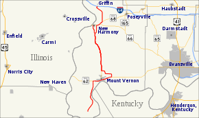
State Road 69 (SR 69) is a part of the Indiana State Road system that runs between Hovey Lake Fish and Wildlife Area and Griffin in US state of Indiana. The 35.07 miles (56.44 km) of SR 69 that lie within Indiana serve as a major conduit. Some of the highway is listed on the National Highway System. Various sections are urban two-lane highway, four-lane divided highway and rural two-lane highway. The highway passes through residential, industrial and commercial properties.
SR 69 was first designated as a state road in 1931. SR 69 replaced the original State Road 20 designation of the highway which dated back to the formation of the Indiana state road system. SR 20 ran from Mount Vernon to New Harmony. SR 69 also replaced the second designation of the highway, SR 65, from the Ohio River to New Harmony.
Despite its proximity to Interstate 69, the two routes have no relation to each other.
Route description
SR 69 begins at the Hovey Lake Fish and Wildlife Area in southwestern Posey County, near the confluence of the Ohio River and the Wabash River. It proceeds roughly northeast as a rural two-lane on the banks of the Hovey Lake. The road turns due north, away from the lake, and towards Mount Vernon. The highway turn northwest passing around the southwest side of Mount Vernon, as a two-lane highway passing through farmland. The road turns east onto SR 62 and the two routes pass through downtown Mount Vernon. On the east side of downtown the road becomes a four-lane divided highway. Soon after SR 69 leaves the divided highway heading north. The route heads away from SR 62, as a four-lane undivided highway. The highway narrows to a two-lane highway and has a crossing with the Evansville Western Railroad track.[4][5][6]

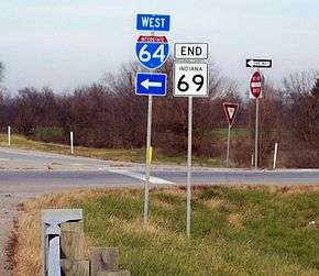
After the track, the roadway turns due west and has a sharp turn back due north, north of Mount Vernon. The highway heads north-northwest towards New Harmony as a rural two-lane highway, passing through mainly farmland with some woodlands. The route passes east of the Harmonie State Park and bypasses New Harmony to the southeast. SR 69 begins a concurrency with SR 66, heading northeast. Soon after the concurrency begin it ends with SR 66 heading due east and SR 69 still heading northeast. At an intersection with the western terminus of SR 68, SR 69 heads due north, before turning northwest. The highway makes a sharp curve heading northeast towards Griffin where it terminates at Interstate 64 (I–64).[4][6]
The only segment of SR 69 that is included as a part of the National Highway System (NHS), is between SR 62 and I–64.[7] The NHS is a network of highways that are identified as being most important for the economy, mobility and defense of the nation.[8] The highway is maintained by the Indiana Department of Transportation (INDOT) like all other state road in the state. The department tracks the traffic volumes along all state highways as a part of its maintenance responsibilities using a metric called average annual daily traffic (AADT). This measurement is a calculation of the traffic level along a segment of roadway for any average day of the year. In 2010, INDOT figured that lowest traffic levels were the 260 vehicles and 20 commercial vehicles used the highway daily near the southern terminus. The peak traffic volumes were 16,500 vehicles and 2,240 commercial vehicles AADT along the section of SR 69 that is concurrent with SR 62.[9]
History
By 1923 the route that SR 69 takes today was signed as SR 20 from Mount Vernon to New Harmony, the rest was county roads.[10] In 1927, the whole segment of SR 20 was renumber SR 65.[11][12] The number was changed one last time, in 1931, this time to SR 69. In that year the route was extended south to the Ohio River, with a ferry across the river to Kentucky.[13]
Eventually it was connected to Interstate 64 at the Griffin exit and rerouted to bypass New Harmony. In the late 1990s, the highway was routed onto the new William Keck Bypass on the eastern side of Mount Vernon.
Major intersections
The entire route is in Posey County.
| Location | mi[1] | km | Destinations | Notes | |
|---|---|---|---|---|---|
| Point Township | 0.00 | 0.00 | Dead End | Southern terminus of SR 69 at Hovey Lake Fish and Wildlife Area. | |
| Mt. Vernon | 8.21 | 13.21 | Western end of SR 62 concurrency | ||
| 13.48 | 21.69 | Eastern end of SR 62 concurrency | |||
| Harmony Township | 25.91 | 41.70 | Eastern terminus of SR 269; spur to Harmonie State Park. | ||
| Harmony Township | 28.81 | 46.37 | Western end of SR 66 concurrency | ||
| 29.67 | 47.75 | Eastern end of SR 66 concurrency | |||
| 30.48 | 49.05 | Western terminus of SR 68 | |||
| Griffin | 35.07 | 56.44 | Northern terminus of SR 69 | ||
1.000 mi = 1.609 km; 1.000 km = 0.621 mi
| |||||
References
- 1 2 Indiana Department of Transportation (2004). Reference Post Book (PDF). Indianapolis: Indiana Department of Transportation. S-69. Archived (PDF) from the original on October 6, 2014. Retrieved November 6, 2012.
- ↑ "Maintenance on 391 Miles of Roads". The Franklin Eveing Star. September 25, 1931. p. 1. Retrieved October 20, 2016 – via Newspapers.com.

- ↑ "Maintenance on 391". The Franklin Eveing Star. September 25, 1931. p. 3. Retrieved October 20, 2016 – via Newspapers.com.
- 1 2 Indiana Department of Transportation (2012). Indiana Transportation Map (PDF) (Map) (2011–12 ed.). 1:550,000. Indianapolis: Indiana Department of Transportation. § P1–N2. OCLC 765461296. Retrieved November 6, 2012.
- ↑ Indiana Department of Transportation (August 23, 2011). Indiana Railroad Map (PDF) (Map). 1:633,600. Indianapolis: Indiana Department of Transportation. Retrieved November 6, 2012.
- 1 2 Google (November 6, 2012). "Indiana State Road 69" (Map). Google Maps. Google. Retrieved November 6, 2012.
- ↑ Federal Highway Administration (December 2003). National Highway System: Indiana (PDF) (Map). Scale not given. Washington, DC: Federal Highway Administration. Retrieved November 6, 2012.
- ↑ "National Highway System". Federal Highway Administration. August 26, 2010. Retrieved August 9, 2011.
- ↑ "INDOT Traffic Zones". Indiana Department of Transportation. 2010. Retrieved July 9, 2012.
- ↑ Indiana State Highway Commission (1923). State Highway Map, State of Indiana (Map). Indianapolis: Indiana State Highway Commission. Retrieved November 6, 2012 – via IUPUI University Library.
- ↑ Rand McNally (1926). Road Map of Indiana (Map). Chicago: Rand McNally. Retrieved November 6, 2012 – via Broer Map Library.
- ↑ Indiana State Highway Commission (1927). State Highway System of Indiana (PDF) (Map). Indianapolis: Indiana State Highway Commission. Retrieved November 6, 2012 – via Indiana University Bloomington Libraries.
- ↑ Indiana State Highway Commission (September 30, 1930). State Highway System of Indiana (PDF) (Map). Indianapolis: Indiana State Highway Commission. Retrieved November 6, 2012 – via Indiana University Bloomington Libraries.