Indiana State Road 445
| ||||
|---|---|---|---|---|
 | ||||
| Route information | ||||
| Maintained by INDOT | ||||
| Length: | 3.50 mi[1] (5.63 km) | |||
| Major junctions | ||||
| West end: |
| |||
|
| ||||
| East end: |
| |||
| Location | ||||
| Counties: | Greene | |||
| Highway system | ||||
| ||||

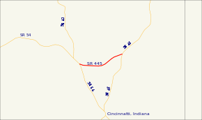
State Road 445 (SR 445) is a short connector route, just 3.50 miles (5.63 km) long, in eastern Greene County, just north of the small town of Cincinnati. It connects SR 54, SR 45, and I-69 (Exit 104).
Route description
SR 445 begins at SR 54 with a flashing light, near the Greene County Inn (also a cafe). It then runs east to a three-way intersection where it meets SR 45. It then continues east, coming to its eastern terminus at exit 104 on Interstate 69 (I-69).
History
SR 445 originally terminated at SR 45, but when I-69 opened, it was extended east.
Major intersections
The entire route is in Greene County.
| Location | mi[1] | km | Destinations | Notes | |
|---|---|---|---|---|---|
| Bloomfield | 0.00 | 0.00 | Western terminus of SR 445 | ||
| 1.41 | 2.27 | Former eastern terminus of SR 445 | |||
| Cincinnati | 3.50 | 5.63 | Eastern terminus of SR 445 | ||
| 1.000 mi = 1.609 km; 1.000 km = 0.621 mi | |||||
References
- 1 2 "INDOT Roadway Referencing System" (PDF).
External links
This article is issued from Wikipedia - version of the 1/29/2016. The text is available under the Creative Commons Attribution/Share Alike but additional terms may apply for the media files.