Indiana State Road 301
| ||||
|---|---|---|---|---|
 | ||||
| Route information | ||||
| Maintained by INDOT | ||||
| Length: | 9.582 mi[1] (15.421 km) | |||
| Major junctions | ||||
| South end: |
| |||
| North end: |
| |||
| Highway system | ||||
| ||||

State Road 301 in the U.S. state of Indiana is a short north–south route in Wells County in the northeastern part of the state.
Route description
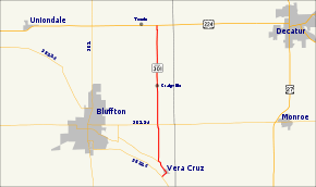
State Road 301 begins at State Road 116 in the town of Vera Cruz and travels north along the east side of Ouabache State Park, through Craigville. It terminates at U.S. Route 224 about a mile east of Tocsin.
Major intersections
The entire route is in Wells County.
| Location | mi[1] | km | Destinations | Notes | |
|---|---|---|---|---|---|
| Vera Cruz | 0.000 | 0.000 | Southern terminus of SR 301 | ||
| Lancaster Township | 3.529 | 5.679 | |||
| 9.582 | 15.421 | Northern terminus of SR 301 | |||
| 1.000 mi = 1.609 km; 1.000 km = 0.621 mi | |||||
References
- 1 2 Indiana Department of Transportation (July 2015). Reference Post Book (PDF). Indianapolis: Indiana Department of Transportation. Retrieved October 4, 2016.
External links
This article is issued from Wikipedia - version of the 10/4/2016. The text is available under the Creative Commons Attribution/Share Alike but additional terms may apply for the media files.