Iberian nautical sciences, 1400–1600

Throughout the early age of exploration, it became increasingly clear that the residents of the Iberian Peninsula were experts at navigation, sailing, and expansion. From Henry the Navigator’s first adventures down the African coast to Columbus’s fabled expedition resulting in the discovery of the new world, the figures that catalyzed the European appetite for expansion and imperialism heralded from either Spain or Portugal. However, merely a century earlier, nautical travel for most peoples was resigned to keeping within sight of a coastline and very rarely did ships venture out into deeper waters. The period’s ships were not able to handle the forces of open ocean travel and the crewmen had neither the ability nor the necessary materials to keep themselves from getting lost. A sailor’s ability to travel was dictated by the technology available, and it wasn’t until the late 15th century that the development of the nautical sciences on the Iberian Peninsula allowed for the genesis of long distance shipping by directly effecting, and leading to the creation of, new tools and techniques relative to navigation. Christopher Columbus’s famous expedition, which crossed the ocean in 1492, was arguably the first contact the civilized world had with the newly discovered continent. Financed and sponsored by Queen Isabella of Spain, his journey would open the door to new trading lanes, imperialist appetites, and the meeting of cultures.[1] Portugal and Spain became the world’s foremost leaders in deep water navigation and discovery because of their sailing expertise and the advancement of nautical sciences benefiting their ability to sail further, faster, more accurately, and safer than other states. Vast amounts of precious minerals and lucrative slaves were poured into Iberian treasuries between the late 15th and mid to late 17th centuries because of Spanish and Portuguese domination of Atlantic trade routes.[2] The golden age of Spain was a direct result of the advancements made in navigation technology and the sciences which allowed for deep water sailing.
To the population of Europe, trans-oceanic navigation was an almost inconceivably huge idea, yet the world would never be the same because a man with the simplest of tools managed to plot his way across the second largest body of water on the planet. Without those rudimentary yet extremely critical instruments, the ambitions of Columbus, along with his sponsoring state, would have been crushed. The development of nautical sciences, including the augmentation of pre-existing techniques and tools, on the Iberian Peninsula generated new technology and had a direct, visible, and lasting effect on long range ship board navigation.
The influence of Prince Henry the Navigator
| Iberian nautical sciences, 1400–1600 | |
|---|---|
| Duke of Viseu | |
 | |
| Born |
4 March 1394 Oporto, Portugal |
| Died |
13 November 1460 (aged 66) Sagres, Algarve, Portugal |
| House | House of Aviz |
| Father | John I of Portugal |
| Mother | Philippa of Lancaster |
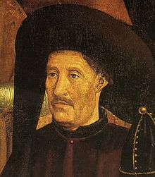
Prior to the 14th century, navigation by European sailors was a crude imitation of what was to come. The technology available was not suitable for anything more ambitious than coast hugging voyages to known landmasses. Captains were limited to technology developed centuries earlier, like the kamal of Arabian genesis, a crude instrument used to measure latitude, and ships with designs which prohibited their use due to the crushing swells, turbulent weather, and material attrition of an open ocean expedition. It was not until Prince Henry the Navigator of Portugal was born in 1394 and gained influence at court through the 15th century that exploration and the development of nautical sciences became priorities under the Iberian governments.[4] Having been part of the crusades as a young man, Henry’s world became ever larger as he traveled the world under the banner of Christ. Even though a zealous and sometimes violent catholic, he did not disregard tales he had heard of Arabian exploration and lands beyond what was known. He had heard about the voyages of Abufeda and Albyruny, two Arabian geographers, and their recollections of travel along the western coast of Africa and began to wonder where the continents of Europe and Africa ended.[5] The prince’s mind was constantly intrigued. Henry wished to know how far the Muslim territories in Africa extended, and whether it was possible for him to reach the Orient by sea, both due to his desire to capitalize on the lucrative spice trade and pro-catholic sentiment.[6] Upon returning to Portugal, it was clear that his travels imprinted upon Henry the desire for further exploration and discovery, along with a desire to find a land “free of the Saracen”, which soon became clear as he took a more visible role in his father’s court.
Prince Henry the Navigator’s overwhelming desire to expand his knowledge of the known world directly led to the advancement of the nautical sciences. Having traveled extensively, it was not revelatory knowledge that the ships and tools available would not be adequate in order to fulfill expansionist and exploratory desires. He realized that his efforts would only be benefited by becoming an expert in, and patron of, the sciences. According to Martins, “He was a true scientist. He spent whole days and nights studying, experimenting … not speculating on the vague fanciful theories of theology or metaphysics, but seeking ever after … facts which could be applied to the everyday things of life.”[7] Reportedly he also lavished gifts upon visitors to court in the hopes of obtaining mysteries of navigation, seamanship, and knowledge of other countries.[8]
The town of a prince
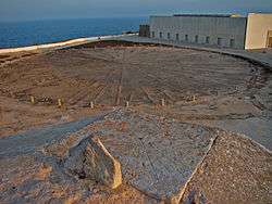
Eventually founding a town on the extreme southwest coast at Cape St. Vincent which came to be called the Vila do Infante, or the Prince’s Town, Henry attempted to concentrate the available nautical knowledge. Anchored in an area that seemed the gateway to the sea, the town was situated with the strait of Gibraltar to its south, the Mediterranean to its east, and the vast emptiness of the Atlantic to the west.[9] It was a perfect harbor within which to nurse the fledgling ideas of the age of exploration and it was arguably here that the first rudimentary school for nautical navigation was born. The dedication he had towards expanding the available knowledge, techniques, and tools available for exploration brought imperialist desires to the forefront of most major powers’ agenda and catalyzed the age of exploration, trade, empire, and cultural interaction that would follow.
During the time of Prince Henry and the following centuries, nautical science became the focus of many of Europe’s most prominent experts in mathematics, astronomy, geography, meteorology, and physics. By applying their specific areas of expertise to the problems of seafaring navigation, many of the statutes of sailing and precursors to modern navigation were born. Up until the late 15th century, the most a sailor could rely on was his compass pointing north, his cross-staff, and the few sparsely detailed nautical charts in his possession.[10] More accurate tools were not needed until the use of the caravel, a speedy vessel ideally suited to the ocean, became widespread. As sea travel became increasingly more important, sailors understood that the farther from coast they ventured, the more they would have to deal with currents, wind intensity and direction, star position based upon hemisphere, ship direction and speed.[11] The problems presented to exploration by the constantly shifting, always dangerous, and vastly infinite nature of the world’s oceans were confronted and overcome by the development and application of nautical science.
The kamal
The earliest known way a sailor could accurately measure his latitude through the use of quantitative methods of navigation was by using a tool known as the kamal. Developed sometime in the 9th century by explorers of Arabian descent, it was used to sight the Pole Star, the only motionless cosmic body in the northern hemisphere, and its height from the horizon in order to determine where upon an east/west grid a ship lay. Its genesis was among the Islamic empires of the pre-modern era, but the kamal managed to be used by a number of different cultures, including India in the 11th century, before it became common Iberian ship pilots. It was a crude tool that consisted of a bone or wood rectangle with a knotted cord measuring arm’s length tied to it.[12] By holding the string in their teeth and sighting the horns of the kamal along the horizon, a sailor could deduce the altitude of the Pole star, and thus his relative latitude, through the number of knots visible.
The cross-staff
Another pre-existing, but emerged later than the kamal, navigation instrument was the cross-staff. The first working version of a cross-staff was developed for astronomical study in the 14th century and was later converted by Named due to its construction, the cross-staff was a cruciform piece of wood. A sailor or astronomer would sight the long arm along the horizon and the transverse arm would be raised to the position of the sun. Markings along its base represented degrees of measurement which could then be converted to angular measurement and eventually north/south position. But the damaging effects looking directly at the sun for extended periods of time coupled with the varied nature of a ship’s deck while under sail made it a very crude and unreliable instrument to work with.[13] The lack of reliable instruments with which to determine location hindered the efforts of sailors and explorers until the later emergence of more advanced apparatuses.
However beneficial the kamal and cross-staff may have been in the early period of exploration, the more difficult part of celestial navigation was determining longitude and here is where problems began. Early exploration, particularly in Portugal, hugged coastlines and thus only latitude was needed in order to determine location, it could merely be cross referenced with position based upon coastal maps, known as portolan charts. Here the kamal was undeniably useful, but once a captain turned his prow to open water the comfort of a coastline was removed and the problems of navigation exponentially increased.
The quadrant

Another latitude-divining instrument was the quadrant. Although their functions were the same, they were developed independently for separate use; the kamal was nautical while the quadrant was astronomical. The idea was born with Ptolemy in the 1st century, and was once again pioneered by the Arabs; its intended purpose was to solve trigonometric functions dictating celestial movement. However, the dual sighting mechanism of the period was too complicated, time consuming, and required too many men for practical use aboard a ship, as a result Iberian captains stripped it down to its most basic parts in order for it to be applied to navigation.[14] The apparatus itself was either a wood or brass quarter circle with degree measurements painted along its length and a length of string attached to the point to serve as a plumb bob. Serving the same purpose as the kamal, only magnitudes more accurate, it was used by suspending it from the string and measuring celestial degrees along its lower arc. It was not until arriving within Europe that the technology itself was altered and made available to seafarers due to the necessity of accurate latitudinal measurement.
Martin Cortes and the astrolabe

Oftentimes the lives of sailors and their captain were completely dependent upon precise plotting of current location and anticipated destination, as a result a number of techniques and instruments were employed in order to ensure the accuracy of a reading. Designed to work in concert with a quadrant, which came to replace the kamal entirely in the 14th century, the mariner's astrolabe also measured the altitude of celestial bodies; however this tool could use the sun as a reference point as well thus allowing for the continual plotting of a ship’s course in day or night.[15] It also had the ability to determine latitude in rough seas, an essential ability for long distance mariners due to the unpredictability of the sea; the quadrant and kamal both required calm waters.
Mentioned as early as the close of the 13th century, a conclusive guide on its construction and use was not available until 1551 when Spanish cosmographer Martin Cortes de Albacar published what would become one of the first manuals on seafaring navigation. Cortes himself was born in Aragon in 1510.[16] Maturing during the fervor of the age of exploration, he devoted his life to the nautical sciences and developed the mariner's astrolabe along with investigating and proposing magnetic deviation and the existence of magnetic poles. He spent the second half of his life from 1530 until his death in Cadiz as an instructor to ship pilots on the topics of both cosmography and navigation. Translated into English as the Arte of Navigation, his book became the backbone of sailing instruction for many of the world’s naval powers until the 19th century.[16]
Pedro Nunes
The astrolabe itself was not the sole product of Cortes, but was improved by a Portuguese mathematician, Pedro Nunes. Born at the outset of the 16th century, he applied much of his life to improving the mathematics of navigation and augmented the astrolabe by including a device he invented known as the nonius.[17] Its addition to the astrolabe allowed for corrections to be made during swells, the astrolabe’s application no longer relied on the intercession of good weather. Publishing his influential Tratado da Sphera in 1537, it included two exposés on questions of navigation which were approached, for the first time, through mathematical application. He was later in life invited to court by King John III of Portugal and was named Royal Cosmographer in 1529.[18] Oceanography was born as seafarers began to investigate the nature of the seas. Henry the Navigator himself, along with his expeditions, took part in studying currents and wind patterns. Information on gyres, currents, tides, and trade winds were all recorded and studied in order to determine if the information could benefit sailors. The patronage of the sciences, particularly those benefiting navigation, by the Portuguese and Spanish crowns propelled their states to the forefront of exploration, discovery, and empire.
Abraham Zacuto and the ephemerides
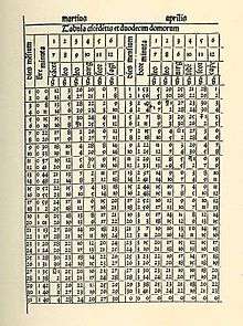
Once out of sight of the coast, Portuguese and Spanish ship pilots could rely upon the astrolabe and quadrant to determine their location on a north/south reference, however longitude was noticeably more difficult to acquire. The problem was time. Out on the vast stretches of the ocean, it is very difficult to keep track of time once leaving port. In order to calculate longitude a sailor would need to know the time difference between his current location and a fixed point somewhere on earth, usually the port of call. Even if one could determine the time of day while in deep waters, they still needed to know the time at their home port. The answer was the ephemerides, astronomical charts plotting the location of the stars over a distinct period of time. Published in 1496 by the Jewish astronomer, astrologer, and mathematician Abraham Zacuto, the Almanach Perpetuum included tables for the movements of stars.[15] Through the use of an astrolabe, also perfected by Zacuto who advanced it from a crude wooden tool to an accurate brass instrument, sailors could determine the time at home. Zacuto himself was born in Spain in 1451 and took refuge in Lisbon during the expulsion of the Jews. He eventually was invited by King John II of Portugal, much like Pedro Nunes, to become the Royal Astronomer, a position he accepted and used to promote exploration, particularly investigating a sea route to India.[15]
The nocturnal
.jpg)
In order to accurately record time on board a vessel sundials had been attempted, however the unpredictable nature of swells made the actual reading of the instrument almost impossible. Up until the emergence of the nocturnal, the only way captains could keep track of time was through the use of sand or water clocks, for example an hourglass. However, they required the constant attention for the duration of the voyage in order to reset the cycles on the hour. With the publishing of the Arte of Navigation by Cortes came the first detailed description of the construction and use of a nocturnal, once again an apparatus that relied on the stars.[16] The nocturnal revolutionized long distance seafaring by complementing the use of the astrolabe and ephemerides by now giving sailors an accurate tool with which to discover the time at their position. Both Zacuto and Cortes were respected mathematicians and had determined in their respective publications the trigonometric measurements concerning the degrees of latitude and longitude. If a ship’s pilot or navigator used the nocturnal to read their time, and then consulted an astrolabe in concert with astronomical charts they could determine the time distance between themselves and a fixed location. The trigonometry, dictated particularly in Zacuto’s work, then allowed a sailor to calculate the degree difference east or west of the fixed position. For instance, if the time variance between port and ship was two hours, a sailor would know that he was 30 degrees east of port, if he was sailing in the Atlantic from the Iberian Peninsula. Cross referenced with latitude, a captain would know his exact location regardless of landmarks or coastline as long as the night sky was clear.[19] Captains could now plot their course accurately and reliably as they extended their travels farther and farther from home.
Conclusion
However, none of these developments could have come about without a vigorous support of the sciences and the breakthroughs of numerous academics well versed in mathematics, physics, oceanography, and astronomy. Henry the Navigator, the catalyst for Portuguese exploration and imperialism, was himself an ardent and zealous student of the sciences. He may have invited cartographers and astronomers to Sagres in order to improve the science of navigation. The caravel and its deep water design rose to prominence under his patronage of the sciences and exploration. The court of his father was flooded with foreigners enticed by Henry and his appetite for any secrets of navigation they could provide. Although driven by religious motivation forged during the crusades, his influence on Portuguese exploration and patronage of nautical sciences is without doubt. Martin Cortes de Albacar and Abraham Zacuto both published works in the 16th century that became backbones for naval instruction through the end of the 19th century. Cortes’s work included detailed instructions on how to both construct and apply an astrolabe while Zacuto’s Almanach and the ephemerides published within were critical to the use of a nocturnal, notably by both Vasco da Gama and Pedro Álvares Cabral.
Without the advancements made in nautical sciences, particularly by Iberian scientists and explorers, trans-oceanic navigation would have not been possible. The earliest periods of navigation within Portugal and Spain employed the use of crude, antiquated, and unreliable instruments. The kamal and cross-staff, while both useful, lacked the ability to be consistently practically applied on board a ship. They were replaced by the trigonometric quadrant and its semi-circle construction. But even that was unreliable at times because a pilot would need calm waters in order to acquire a reading. Eventually it was used together with the astrolabe, which became a critical piece of equipment for navigation after Martin Cortes de Albacar published his Art. Because it could be used day or night, in rough or calm seas, it was cross referenced with the quadrant in order to gain the most accurate reading possible. Finally, the nocturnal and its accompanied values in the ephemerides granted sailors the ability to plot longitude on the open ocean. Navigation across vast stretches of open water was no longer merely as daunting. An expedition leader, the captains, ships, and crews could all be confident that, barring the intercession of the ocean’s unpredictable nature, a course could be safely and accurately plotted from a port of call to final destination. Portugal to colonized Brazil, Spain to its holdings in Florida, the challenges of thousand mile and multiple month long excursions could be overcome. In the span of a few centuries, nautical sciences had granted man the ability to circumnavigate the globe by 1521, exploit vast reserves of untouched natural resources, open dialogue with previously unknown cultures, and open lucrative new trading routes; the world had become a much larger place.
References
- ↑ Paolo Emilio Taviani. Columbus, the Great Adventure: His Life, His Times, and His Voyages (New York: Orion Books), page 12
- ↑ Fransisco Bethencourt, Portuguese Oceanic Expansion, 1400–1800 (Cambridge [England] : Cambridge University Press), page 113
- ↑ The traditional image of the Prince presented in this page, and coming from the Saint Vincent Panels, is still under dispute.
- ↑ Joaquinn Pedro Oliveira Martins, The Golden Age of Prince Henry the Navigator (New York: Dutton), page 62
- ↑ Joaquinn Pedro Oliveira Martins, The Golden Age of Prince Henry the Navigator (New York: Dutton), page 68
- ↑ Bailey Diffie, Foundations of the Portuguese Empire, 1415–1580 (Minneapolis : University of Minnesota Press), page 121
- ↑ Joaquinn Pedro Oliveira Martins, The Golden Age of Prince Henry the Navigator (New York: Dutton), page 65
- ↑ John Dos Passos, The Portugal Story: Three Centuries of Exploration and Discovery. (Garden City, N.Y. : Doubleday), page 86
- ↑ John Dos Passos, The Portugal Story: Three Centuries of Exploration and Discovery (Garden City, N.Y. : Doubleday), page 89
- ↑ Bailey Diffie, Foundations of the Portuguese Empire, 1415–1580 (Minneapolis : University of Minnesota Press), page 134
- ↑ Bailey Diffie, Foundations of the Portuguese Empire, 1415–1580 (Minneapolis: University of Minnesota Press), page 118
- ↑ Bailey Diffie, Foundations of the Portuguese Empire, 1415–1580 (Minneapolis : University of Minnesota Press), page 133
- ↑ Jeanne Willoz-Egnor, Cross-Staff
- ↑ ThinkQuest: Library, “Early Navigational Instruments”
- 1 2 3 Nissan Mindel, Rabbi Abraham Zacuto (1450–1515)
- 1 2 3 Antonio Barrera-Osorio, Experiencing Nature: The Spanish American Empire and the Early Scientific Revolution (Austin, Texas: University of Texas Press), page 131
- ↑ Bailey Diffie, Foundations of the Portuguese Empire, 1415–1580 (Minneapolis: University of Minnesota Press), page 143
- ↑ Bailey Diffie, Foundations of the Portuguese Empire, 1415–1580 (Minneapolis: University of Minnesota Press), page 142
- ↑ Roland I. Maldonado, Navigation on the High Seas