IB-41 highway (Serbia)
| ||||
|---|---|---|---|---|
|
Државни пут IБ реда 41 Državni put IB reda 41 | ||||
 | ||||
| Route information | ||||
| Maintained by JP "Putevi Srbije" | ||||
| Length: |
82.887 km (51.504 mi) 0.610 km (0.379 mi) unconstructed 83.497 km (51.883 mi) planned 13.979 km (8.686 mi) (excluding Kosovo)[lower-alpha 1] 14.589 km (9.065 mi) (planned excluding Kosovo) | |||
| Major junctions | ||||
| From: |
Bujanovac | |||
| To: |
Štimlje, State Road M-25 Serbia-Kosovo border at Končulj, State Road M-25 | |||
| Location | ||||
| Districts: | Pčinja, Kosovo Pomoravlje, Kosovo (Constitution of Serbia) / Gjilan, Ferizaj (UNMIK) | |||
| Highway system | ||||
| ||||

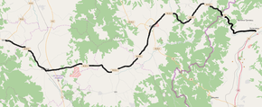
National/State Road 41 is an IB-class road in southern Serbia, connecting Bujanovac with Štimlje. It is located in Southern and Eastern Serbia and Kosovo and Metohija regions.[1] The section between Končulj and Štimlje is controlled by Kosovo government and UNMIK.
Before the new road categorization regulation given in 2013, the route wore the following names: P 125б and P 214 and M 25.3 (before 2012) / 132 and 34 (after 2012).[2][3]
The existing route is a main road with two traffic lanes. By the valid Space Plan of Republic of Serbia the road is not planned for upgrading to motorway, and is expected to be conditioned in its current state.[4]
Sections
| Section number | Length | Distance | Section name |
|---|---|---|---|
| 04101 | 1.188 km (0.738 mi) | 1.188 km (0.738 mi) | Bujanovac-south interchange - Bujanovac (0.610 km (0.379 mi) unconstructed) |
| 04102 | 1.136 km (0.706 mi) | 2.324 km (1.444 mi) | Bujanovac - Bujanovac (Veliki Trnovac) |
| 04103 | 12.265 km (7.621 mi) | 14.589 km (9.065 mi) | Bujanovac (Veliki Trnovac) - Kosovo and Metohija border (Končulj) |
| 04104 | 3.466 km (2.154 mi) | 18.055 km (11.219 mi) | Kosovo and Metohija border (Končulj) - Domorovce |
| 04105 | 2.071 km (1.287 mi) | 20.126 km (12.506 mi) | Domorovce - Donje Korminjane |
| 04106 | 16.960 km (10.538 mi) | 37.086 km (23.044 mi) | Donje Korminjane - Gnjilane (Gornji Makreš) |
| 04107 | 0.150 km (0.093 mi) | 37.236 km (23.137 mi) | Gnjilane (Gornji Makreš) - Gnjilane (Dobrčane) |
| 04108 | 0.088 km (0.055 mi) | 37.324 km (23.192 mi) | Gnjilane (Dobrčane) - Gnjilane (Klokot) |
| 04109 | 5.235 km (3.253 mi) | 42.559 km (26.445 mi) | Gnjilane (Klokot) - Livoč |
| 04110 | 8.612 km (5.351 mi) | 51.171 km (31.796 mi) | Livoč - Klokot |
| 04111 | 17.399 km (10.811 mi) | 68.570 km (42.607 mi) | Klokot - Uroševac (Gnjilane) |
| 04112 | 2.618 km (1.627 mi) | 71.188 km (44.234 mi) | Uroševac (Gnjilane) - Uroševac (Jezerce) |
| 04113 | 7.127 km (4.429 mi) | 78.315 km (48.663 mi) | Uroševac (Jezerce) - Košare |
| 04114 | 5.182 km (3.220 mi) | 83.947 km (52.162 mi) | Košare - Štimlje |
See also
Notes
- ↑ Kosovo is the subject of a territorial dispute between the Republic of Kosovo and the Republic of Serbia. The Republic of Kosovo unilaterally declared independence on 17 February 2008, but Serbia continues to claim it as part of its own sovereign territory. The two governments began to normalise relations in 2013, as part of the Brussels Agreement. Kosovo has received recognition as an independent state from 110 out of 193 United Nations member states.
References
- ↑ "Republic of Serbia - national road network" (PDF). Putevi Srbije (in Serbian).
- ↑ "National road categorization regulation - Official Gazette of Republic of Serbia no. 105/2013 and 119/2013" (PDF). Serbian Spatial Planners Association (in Serbian).
- ↑ "Link between actual and previous section and road markings" (PDF). Putevi Srbije (in Serbian).
- ↑ Space plan of Republic of Serbia from 2010 to 2021
External links
- Official website - Roads of Serbia (Putevi Srbije)
- Official website - Corridors of Serbia (Koridori Srbije) (Serbian)
This article is issued from Wikipedia - version of the 9/10/2016. The text is available under the Creative Commons Attribution/Share Alike but additional terms may apply for the media files.