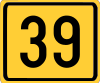
IB-39 highway (Serbia)
| ||||
|---|---|---|---|---|
|
Државни пут IБ реда 39 Državni put IB reda 39 | ||||
 | ||||
| Route information | ||||
| Maintained by JP "Putevi Srbije" | ||||
| Length: |
287.600 km (178.706 mi) 145.681 km (90.522 mi) (excluding Kosovo)[lower-alpha 1] | |||
| Major junctions | ||||
| From: | Pirot | |||
| To: |
Serbia/Kosovo-Montenegro border at Čakor Serbia-Kosovo border at Mutivode, Road M-9 (excluding Kosovo) | |||
| Location | ||||
| Districts: | Pirot, Jablanica, Kosovo, Peć (Constitution of Serbia) / Pristina, Prizren, Peć (UNMIK) | |||
| Highway system | ||||
| ||||
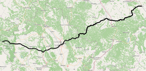
National/State Road 39 is an IB-class road in eastern and southern Serbia, connecting Pirot with Montenegro at Čakor. It is located in Southern and Eastern Serbia and Kosovo and Metohija regions.[1] The section between Mutivode and Čakor is controlled by Kosovo government and UNMIK.
Before the new road categorization regulation given in 2013, the route wore the following names: M 9 and P 101 (before 2012) / 27 (after 2012).[2][3]
The existing route is a main road with two traffic lanes. By the valid Space Plan of Republic of Serbia the road is not planned for upgrading to motorway, and is expected to be conditioned in its current state.[4]
Sections
| Section number | Length (km) | Distance (km) | Section name |
|---|---|---|---|
| 03901 | 4.197 km (2.608 mi) | 4.197 km (2.608 mi) | Pirot - Sadikov Bunar |
| 03902 | 15.420 km (9.582 mi) | 19.617 km (12.189 mi) | Sadikov Bunar - Donji Striževac |
| 03903 | 4.411 km (2.741 mi) | 24.028 km (14.930 mi) | Donji Striževac - Babušnica |
| 03904 | 17.253 km (10.721 mi) | 41.281 km (25.651 mi) | Babušnica - Bonjince |
| 03905 | 4.104 km (2.550 mi) | 45.385 km (28.201 mi) | Bonjince - Svođe |
| 03906 | 15.868 km (9.860 mi) | 61.253 km (38.061 mi) | Svođe - Vlasotince |
| 03907 | 6.988 km (4.342 mi) | 68.241 km (42.403 mi) | Vlasotince - Leskovac-south ( |
| 03908 | 4.830 km (3.001 mi) | 73.071 km (45.404 mi) | Leskovac-south ( |
| 03909 | 1.669 km (1.037 mi) | 74.740 km (46.441 mi) | Leskovac (Vlasotince) - Leskovac (Strojkovce) |
| 03910 | 1.094 km (0.680 mi) | 75.834 km (47.121 mi) | Leskovac (Strojkovce) - Leskovac (Bratmilovce) |
| 03911 | 1.810 km (1.125 mi) | 77.644 km (48.246 mi) | Leskovac (Bratmilovce) - Leskovac (Gornje Stopanje) |
| 03912 | 18.979 km (11.793 mi) | 96.623 km (60.039 mi) | Leskovac (Gornje Stopanje) - Lebane (Bojnik) |
| 03913 | 1.109 km (0.689 mi) | 97.732 km (60.728 mi) | Lebane (Bojnik) - Lebane |
| 03914 | 1.550 km (0.963 mi) | 99.282 km (61.691 mi) | Lebane - Lebane (Krivača) |
| 03915 | 17.931 km (11.142 mi) | 117.213 km (72.833 mi) | Lebane (Krivača) - Negosavlje |
| 03916 | 7.782 km (4.836 mi) | 124.995 km (77.668 mi) | Negosavlje - Maćedonce |
| 03917 | 12.391 km (7.699 mi) | 137.386 km (85.368 mi) | Maćedonce - Tulare |
| 03918 | 8.295 km (5.154 mi) | 145.681 km (90.522 mi) | Tulare - Kosovo and Metohija border (Mutivode) |
| 03919 | 34.117 km (21.199 mi) | 179.798 km (111.721 mi) | Kosovo and Metohija border (Mutivode) - Priština (Lebane) |
| 03542 | 3.200 km (1.988 mi) | 182.998 km (113.710 mi) | Priština (Lebane) - Priština (Peć) (overlap with |
| 03920 | 12.403 km (7.707 mi) | 195.401 km (121.417 mi) | Priština (Peć) - Velika Slatina (Obilić) |
| 03921 | 0.223 km (0.139 mi) | 195.624 km (121.555 mi) | Velika Slatina (Obilić) - Velika Slatina (Magura) |
| 03922 | 10.716 km (6.659 mi) | 206.340 km (128.214 mi) | Velika Slatina (Magura) - Komorane |
| 03923 | 5.977 km (3.714 mi) | 212.317 km (131.928 mi) | Komorane - Lapušnik |
| 03924 | 11.503 km (7.148 mi) | 223.820 km (139.075 mi) | Lapušnik - Kijevo |
| 03925 | 12.237 km (7.604 mi) | 236.057 km (146.679 mi) | Kijevo - Dolac (Hramovik) |
| 03926 | 0.629 km (0.391 mi) | 236.686 km (147.070 mi) | Dolac (Hramovik) - Dolac (Klina) |
| 03927 | 1.592 km (0.989 mi) | 238.278 km (148.059 mi) | Dolac (Klina) - Zajmovo |
| 03928 | 24.488 km (15.216 mi) | 262.766 km (163.275 mi) | Zajmovo - Peć (Vitomirica) |
| 03929 | 1.116 km (0.693 mi) | 263.882 km (163.969 mi) | Peć (Vitomirica) - Peć (Dečani) |
| 03930 | 23.718 km (14.738 mi) | 287.600 km (178.706 mi) | Peć (Dečani) - Serbia/Kosovo-Montenegro border at Čakor |
See also
Notes
- ↑ Kosovo is the subject of a territorial dispute between the Republic of Kosovo and the Republic of Serbia. The Republic of Kosovo unilaterally declared independence on 17 February 2008, but Serbia continues to claim it as part of its own sovereign territory. The two governments began to normalise relations in 2013, as part of the Brussels Agreement. Kosovo has received recognition as an independent state from 110 out of 193 United Nations member states.
References
- ↑ "Republic of Serbia - national road network" (PDF). Putevi Srbije (in Serbian).
- ↑ "National road categorization regulation - Official Gazette of Republic of Serbia no. 105/2013 and 119/2013" (PDF). Serbian Spatial Planners Association (in Serbian).
- ↑ "Link between actual and previous section and road markings" (PDF). Putevi Srbije (in Serbian).
- ↑ Space plan of Republic of Serbia from 2010 to 2021
External links
- Official website - Roads of Serbia (Putevi Srbije)
- Official website - Corridors of Serbia (Koridori Srbije) (Serbian)
This article is issued from Wikipedia - version of the 9/11/2016. The text is available under the Creative Commons Attribution/Share Alike but additional terms may apply for the media files.