Hurricane Juliette (1995)
| Category 4 major hurricane (SSHWS/NWS) | |
 Satellite image of Hurricane Juliette near peak intensity | |
| Formed | September 16, 1995 |
|---|---|
| Dissipated | September 26, 1995 |
| Highest winds |
1-minute sustained: 150 mph (240 km/h) |
| Lowest pressure | 930 mbar (hPa); 27.46 inHg |
| Fatalities | None |
| Damage | None |
| Areas affected | Baja California peninsula, California |
| Part of the 1995 Pacific hurricane season | |
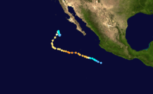
Hurricane Juliette was the strongest hurricane and final tropical cyclone of the inactive 1995 Pacific hurricane season. The tenth named storm of the season, Juliette formed on September 16 from a tropical wave off the southwest coast of Mexico. For the majority of its track, the storm moved toward the west-northwest, and Juliette quickly intensified to major hurricane status. On September 20, the hurricane reached peak winds of 150 mph (240 km/h). Later it turned toward the northeast, briefly threatening the Baja California Peninsula, although the hurricane never affected land.
Meteorological history
A tropical wave moved off the coast of Africa behind Hurricane Luis on August 31. Strong outflow from Luis prevented development of the wave, and it continued westward until crossing into the eastern Pacific Ocean on September 12. Convection increased as it moved through the Gulf of Tehuantepec, and the cloud pattern organized sufficiently to warrant Dvorak classifications for the system on September 15. Based on the development of a low-level circulation, it is estimated the system organized into Tropical Depression Eleven-E on September 16 while located around 290 miles (465 km) south of Manzanillo, Mexico.[1] Due to the tropical depression moving over an area of warm water temperatures with favorable upper level outflow, the National Hurricane Center forecast the tropical depression to slowly intensify to 70 mph (110 km/h) winds within 72 hours the forecast early on September 16.[2]
The tropical depression was small in size, and moving to the west-northwest, intensified into a tropical storm on September 17.[1] Juliette quickly organized with a well-defined band of convection drawn into the circulation.[3] The storm quickly intensified, and subsequent to the development of a small eye Juliette attained hurricane status on September 18, just 42 hours after developing. The eye became better defined as the hurricane moved to the west-northwest, a motion caused by a weak ridge to its north, and Juliette attained major hurricane status early on September 19. Possibly due to increased northeasterly wind shear from an upper-level trough, Juliette stopped its intensification trend, though as it turned to the west it again re-organized. On September 20, while located 420 miles (680 km) southwest of Cabo San Lucas, Juliette attained a peak strength of 150 mph (240 km/h), the strongest tropical cyclone of the season and a Category 4 on the Saffir-Simpson Hurricane Scale.[1]
After maintaining its peak intensity for less than 12 hours, Juliette began to weaken due to an eyewall replacement cycle. After turning to the west-northwest, the winds of the hurricane dropped to 100 mph (160 km/h) by September 22, and the eyewall expanded to about 80 miles (130 km) in diameter. The eyewall contracted to about 40 miles (65 km), and as a result Juliette re-strengthened to attain winds of 105 mph (170 km/h). An eastward moving trough of low pressure turned the hurricane to the north-northeast into an area of cooler water temperatures and increased wind shear. Juliette quickly weakened to a tropical storm late on September 24. The eastward moving trough moved past the storm, resulting in the motion of Juliette turning to a southeast drift. The convection waned and disappeared on September 25, and on September 26 Juliette dissipated while located 450 miles (730 km) west of the southern tip of the Baja California Peninsula.[1]
Preparations and impact
When the motion of Juliette turned to the northeast, some computer models predicted it to continue northeastward and strike Baja California Sur. As a result, the government of Mexico issued a tropical storm watch as a precautionary measure for portions of the state. When the storm weakened rapidly and turned from the coast, the watch was canceled. Juliette remained away from land masses for its lifetime, and as a result there were no reports of damage or deaths.[1] In southern California, however, the hurricane produced high waves that created dangerous surfing conditions.[4] These waves wiped out a fishing derby.[5] The remnants of Hurricane Juliette moved into New Mexico and western Texas, producing scattered showers and thunderstorms.[6]
See also
- Other hurricanes of the same name
- 1995 Pacific hurricane season
- List of Category 4 Pacific hurricanes
References
- 1 2 3 4 5 Richard J. Pasch (1996-02-01). "Hurricane Juliette Tropical Cyclone Report". National Hurricane Center. National Oceanic and Atmospheric Administration. Retrieved 2010-04-12.
- ↑ Britt Max Mayfield (1995-09-17). "Tropical Depression Eleven-E Discussion Three". National Hurricane Center. National Oceanic and Atmospheric Administration. Retrieved 2010-04-12.
- ↑ Edward N. Rappaport (1995-09-17). "Tropical Storm Juliette Discussion Five". National Hurricane Center. National Oceanic and Atmospheric Administration. Retrieved 2010-04-12.
- ↑ Gregory Gross (1995-09-29). "Lobster season arrives with dangerous surf". San Diego Union. Retrieved 2010-04-07.
- ↑ "SEAL BEACH; Big Surf Foils Plan to Catch Stingrays". L.A. Times. 1995-09-26. Retrieved 2011-10-08.
- ↑ "Damp, cool weather prevails". The Telegraph-Herald. 1995-09-25. Retrieved 2011-10-08.
Tropical cyclones of the 1995 Pacific hurricane season | ||
|---|---|---|
 | ||
| ||